Magruder Mountain Topo Map Nevada
To zoom in, hover over the map of Magruder Mountain
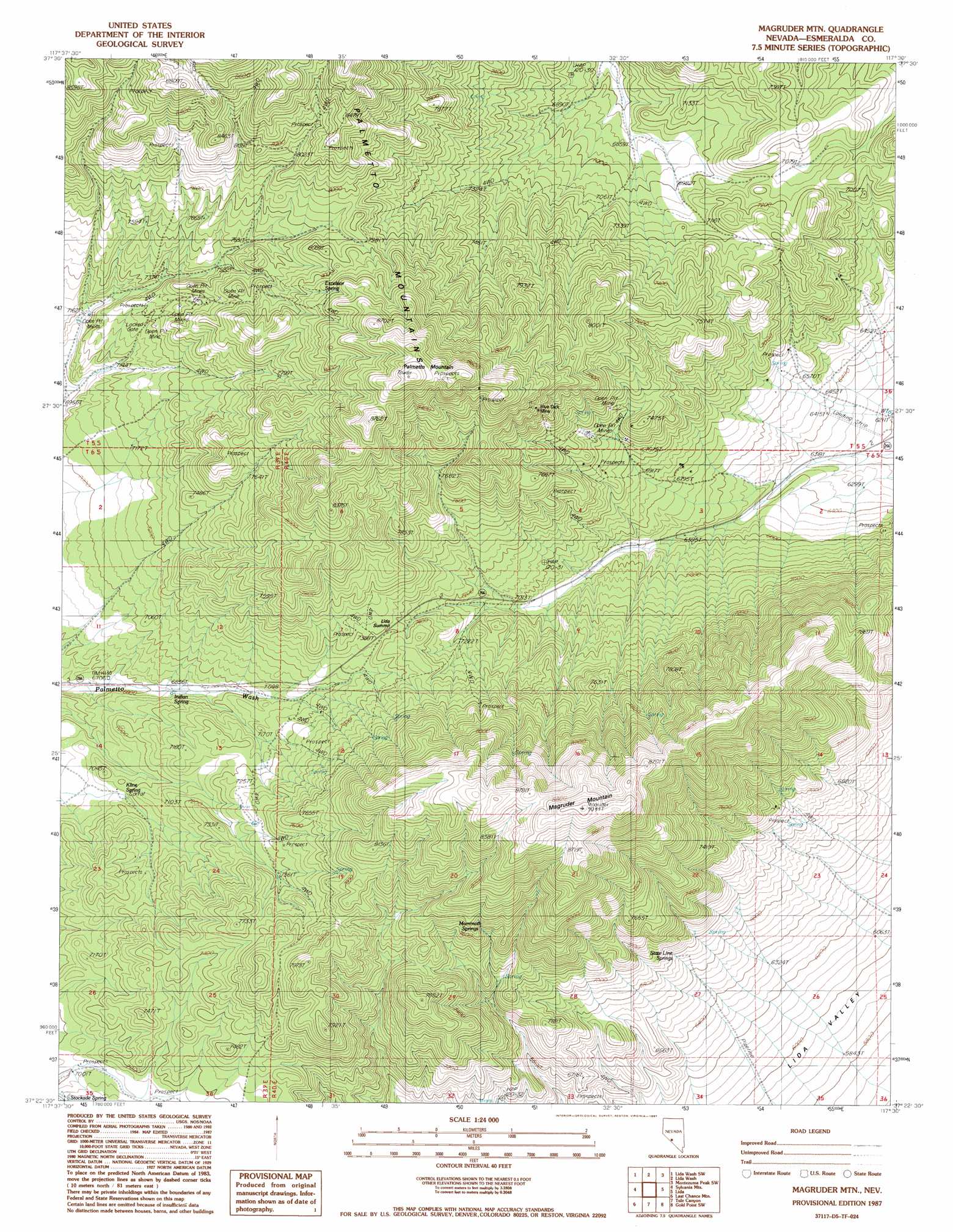
USGS Topo Quad 37117d5 - 1:24,000 scale
| Topo Map Name: | Magruder Mountain |
| USGS Topo Quad ID: | 37117d5 |
| Print Size: | ca. 21 1/4" wide x 27" high |
| Southeast Coordinates: | 37.375° N latitude / 117.5° W longitude |
| Map Center Coordinates: | 37.4375° N latitude / 117.5625° W longitude |
| U.S. State: | NV |
| Filename: | o37117d5.jpg |
| Download Map JPG Image: | Magruder Mountain topo map 1:24,000 scale |
| Map Type: | Topographic |
| Topo Series: | 7.5´ |
| Map Scale: | 1:24,000 |
| Source of Map Images: | United States Geological Survey (USGS) |
| Alternate Map Versions: |
Magruder Mtn NV 1987, updated 1987 Download PDF Buy paper map Magruder Mountain NV 2011 Download PDF Buy paper map Magruder Mountain NV 2014 Download PDF Buy paper map |
1:24,000 Topo Quads surrounding Magruder Mountain
Mohawk Mine |
Lida Wash Nw |
Alcatraz Island |
Split Mountain |
Montezuma Peak |
Oasis Divide |
Lida Wash Sw |
Lida Wash |
Montezuma Peak Sw |
Montezuma Peak Se |
Sylvania Canyon |
Sylvania Mountains |
Magruder Mountain |
Lida |
Mount Jackson |
Horse Thief Canyon |
Last Chance Mountain |
Tule Canyon |
Gold Point Sw |
Gold Point |
East Of Joshua Flats |
Hanging Rock Canyon |
Sand Spring |
West Of Gold Mountain |
Gold Mountain |
> Back to 37117a1 at 1:100,000 scale
> Back to 37116a1 at 1:250,000 scale
> Back to U.S. Topo Maps home
Magruder Mountain topo map: Gazetteer
Magruder Mountain: Gaps
Lida Summit elevation 2264m 7427′Magruder Mountain: Mines
Blue Dick Mine elevation 2383m 7818′Buster Mine elevation 2330m 7644′
Champion Mine elevation 2185m 7168′
Kentucky Mine elevation 2071m 6794′
Mattmueller Mine elevation 2224m 7296′
Nevada Silver State Mine elevation 2320m 7611′
New York Mine elevation 2217m 7273′
Virginia Mine elevation 2056m 6745′
Magruder Mountain: Ranges
Palmetto Mountains elevation 2417m 7929′Magruder Mountain: Springs
Excelsior Spring elevation 2481m 8139′Indian Spring elevation 2098m 6883′
Indian Spring elevation 2252m 7388′
Kline Spring elevation 2137m 7011′
Mammoth Springs elevation 2305m 7562′
State Line Springs elevation 2100m 6889′
Magruder Mountain: Summits
Magruder Mountain elevation 2754m 9035′Palmetto Mountain elevation 2710m 8891′
Magruder Mountain digital topo map on disk
Buy this Magruder Mountain topo map showing relief, roads, GPS coordinates and other geographical features, as a high-resolution digital map file on DVD: