Montezuma Peak Sw Topo Map Nevada
To zoom in, hover over the map of Montezuma Peak Sw
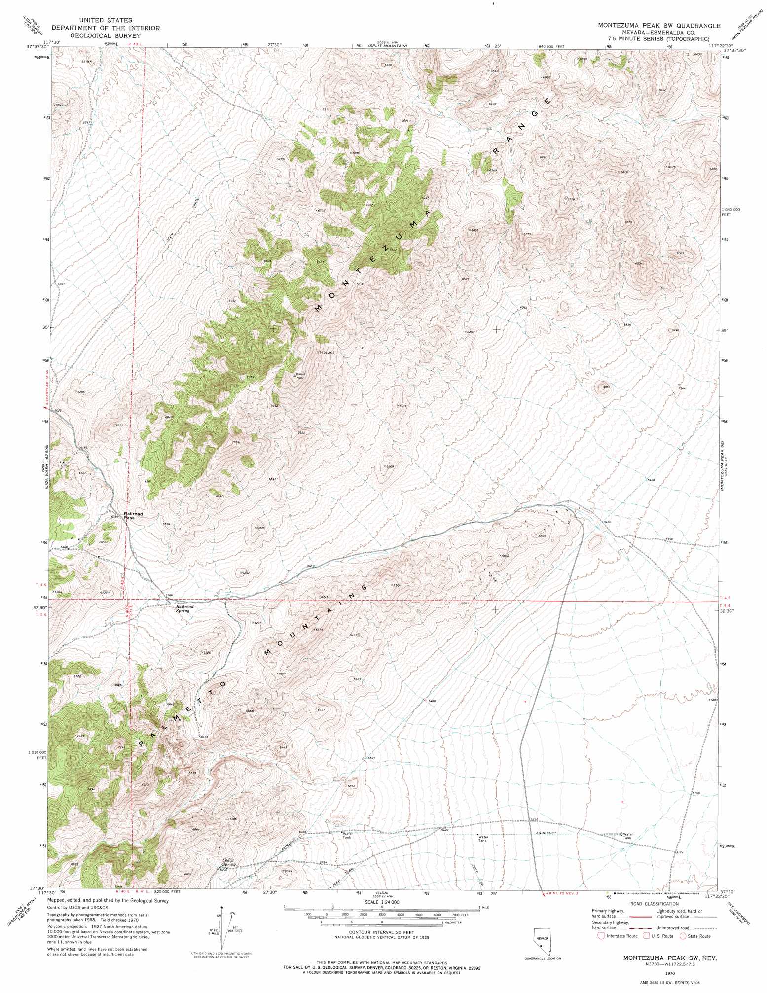
USGS Topo Quad 37117e4 - 1:24,000 scale
| Topo Map Name: | Montezuma Peak Sw |
| USGS Topo Quad ID: | 37117e4 |
| Print Size: | ca. 21 1/4" wide x 27" high |
| Southeast Coordinates: | 37.5° N latitude / 117.375° W longitude |
| Map Center Coordinates: | 37.5625° N latitude / 117.4375° W longitude |
| U.S. State: | NV |
| Filename: | o37117e4.jpg |
| Download Map JPG Image: | Montezuma Peak Sw topo map 1:24,000 scale |
| Map Type: | Topographic |
| Topo Series: | 7.5´ |
| Map Scale: | 1:24,000 |
| Source of Map Images: | United States Geological Survey (USGS) |
| Alternate Map Versions: |
Montezuma Peak SW NV 1970, updated 1973 Download PDF Buy paper map Montezuma Peak SW NV 1970, updated 1978 Download PDF Buy paper map Montezuma Peak SW NV 2011 Download PDF Buy paper map Montezuma Peak SW NV 2014 Download PDF Buy paper map |
1:24,000 Topo Quads surrounding Montezuma Peak Sw
Silver Peak |
Goat Island |
Paymaster Ridge |
Alkali |
Mcmahon Ridge |
Lida Wash Nw |
Alcatraz Island |
Split Mountain |
Montezuma Peak |
Goldfield |
Lida Wash Sw |
Lida Wash |
Montezuma Peak Sw |
Montezuma Peak Se |
Ralston |
Sylvania Mountains |
Magruder Mountain |
Lida |
Mount Jackson |
Stonewall Pass |
Last Chance Mountain |
Tule Canyon |
Gold Point Sw |
Gold Point |
Scottys Junction Sw |
> Back to 37117e1 at 1:100,000 scale
> Back to 37116a1 at 1:250,000 scale
> Back to U.S. Topo Maps home
Montezuma Peak Sw topo map: Gazetteer
Montezuma Peak Sw: Gaps
Railroad Pass elevation 1952m 6404′Montezuma Peak Sw: Mines
Gold Hill Mine elevation 2009m 6591′Marvel Group elevation 2009m 6591′
Park Hill Group elevation 2009m 6591′
Silver Coin Property elevation 2009m 6591′
Montezuma Peak Sw: Springs
Alida Spring elevation 1691m 5547′Cedar Spring elevation 1889m 6197′
Railroad Spring elevation 1879m 6164′
Railroad Spring (historical) elevation 1884m 6181′
Montezuma Peak Sw digital topo map on disk
Buy this Montezuma Peak Sw topo map showing relief, roads, GPS coordinates and other geographical features, as a high-resolution digital map file on DVD: