Waucoba Mountain Topo Map California
To zoom in, hover over the map of Waucoba Mountain
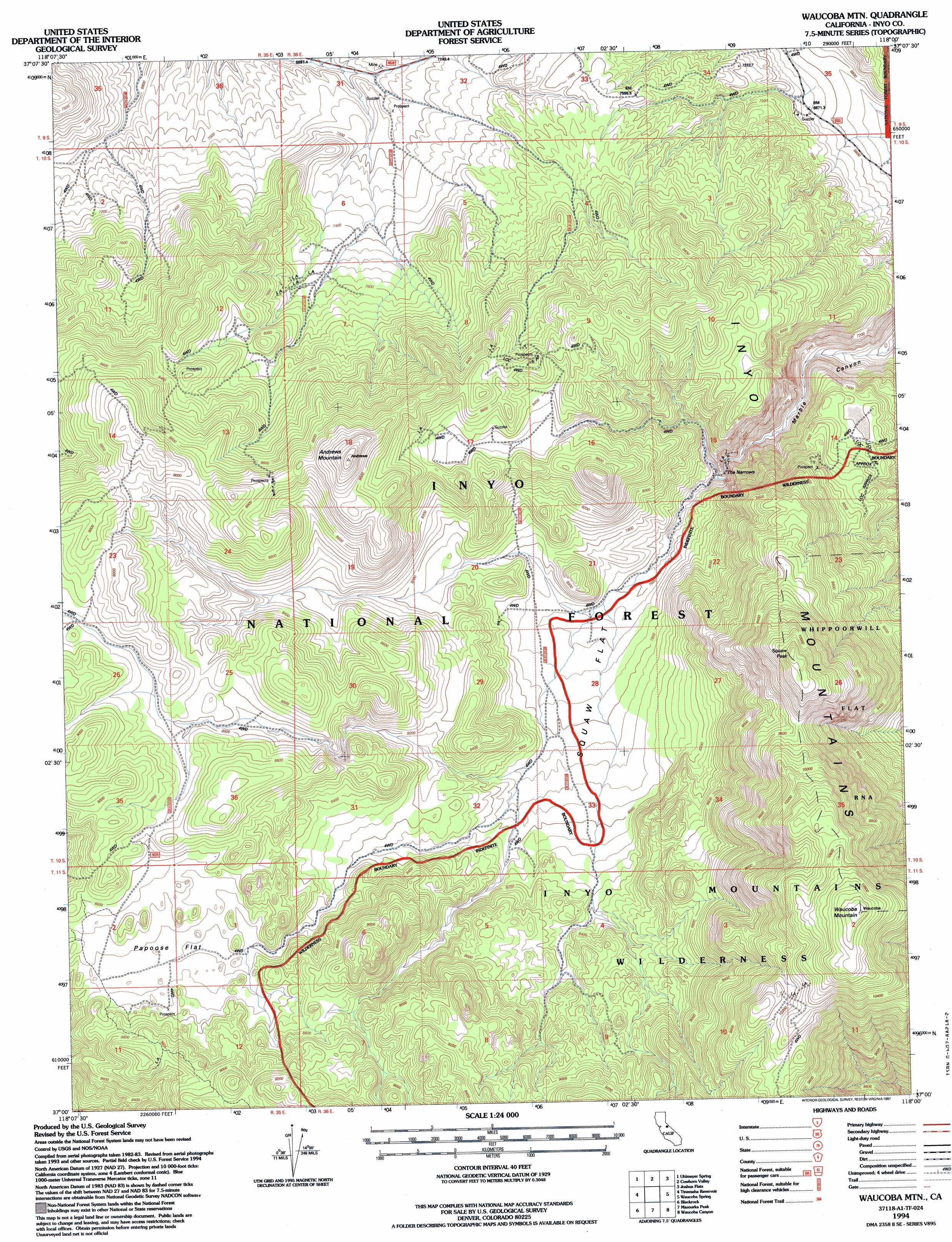
USGS Topo Quad 37118a1 - 1:24,000 scale
| Topo Map Name: | Waucoba Mountain |
| USGS Topo Quad ID: | 37118a1 |
| Print Size: | ca. 21 1/4" wide x 27" high |
| Southeast Coordinates: | 37° N latitude / 118° W longitude |
| Map Center Coordinates: | 37.0625° N latitude / 118.0625° W longitude |
| U.S. State: | CA |
| Filename: | o37118a1.jpg |
| Download Map JPG Image: | Waucoba Mountain topo map 1:24,000 scale |
| Map Type: | Topographic |
| Topo Series: | 7.5´ |
| Map Scale: | 1:24,000 |
| Source of Map Images: | United States Geological Survey (USGS) |
| Alternate Map Versions: |
Waucoba Mtn CA 1987, updated 1987 Download PDF Buy paper map Waucoba Mtn CA 1990, updated 1995 Download PDF Buy paper map Waucoba Mtn CA 1994, updated 1997 Download PDF Buy paper map Waucoba Mountain CA 2012 Download PDF Buy paper map Waucoba Mountain CA 2015 Download PDF Buy paper map |
| FStopo: | US Forest Service topo Waucoba Mountain is available: Download FStopo PDF Download FStopo TIF |
1:24,000 Topo Quads surrounding Waucoba Mountain
Poleta Canyon |
Westgard Pass |
Deep Springs Lake |
Soldier Pass |
Horse Thief Canyon |
Big Pine |
Uhlmeyer Spring |
Cowhorn Valley |
Joshua Flats |
East Of Joshua Flats |
Fish Springs |
Tinemaha Reservoir |
Waucoba Mountain |
Waucoba Spring |
East Of Waucoba Spring |
Aberdeen |
Blackrock |
Mazourka Peak |
Waucoba Canyon |
East Of Waucoba Canyon |
Kearsarge Peak |
Independence |
Bee Springs Canyon |
Pat Keyes Canyon |
Lower Warm Springs |
> Back to 37118a1 at 1:100,000 scale
> Back to 37118a1 at 1:250,000 scale
> Back to U.S. Topo Maps home
Waucoba Mountain topo map: Gazetteer
Waucoba Mountain: Flats
Papoose Flat elevation 2580m 8464′Squaw Flat elevation 2358m 7736′
Waucoba Mountain: Gaps
The Narrows elevation 2250m 7381′Waucoba Mountain: Mines
Andrews Numbers 1-17 Prospects elevation 2702m 8864′Blue Crystal Numbers 1-6 Prospects elevation 2654m 8707′
Dorothy Prospect elevation 2533m 8310′
El Sobrante Prospect elevation 2175m 7135′
Four Horsemen Prospect elevation 2470m 8103′
Iron Side Prospect elevation 2394m 7854′
Lucky Strike Prospect elevation 2269m 7444′
Narrows Claim elevation 2564m 8412′
Narrows Numbers 1-6 Prospects elevation 2242m 7355′
Pasadena Numbers 1-2 Prospects elevation 2353m 7719′
Pearl Prospect elevation 2331m 7647′
San Pedro Numbers 1-6 Prospects elevation 2400m 7874′
Silver Princess Numbers 1-4 Prospects elevation 2450m 8038′
Squaw Flat Numbers 1-4 Mines elevation 2389m 7837′
Squaw Flat Placer Mine elevation 2328m 7637′
Three Fingers Prospect elevation 2349m 7706′
Waucoba Mountain: Springs
Squaw Springs elevation 2738m 8982′Waucoba Mountain: Summits
Andrews Mountain elevation 2875m 9432′Squaw Peak elevation 3110m 10203′
Waucoba Mountain elevation 3377m 11079′
Waucoba Mountain digital topo map on disk
Buy this Waucoba Mountain topo map showing relief, roads, GPS coordinates and other geographical features, as a high-resolution digital map file on DVD: