Courtright Reservoir Topo Map California
To zoom in, hover over the map of Courtright Reservoir
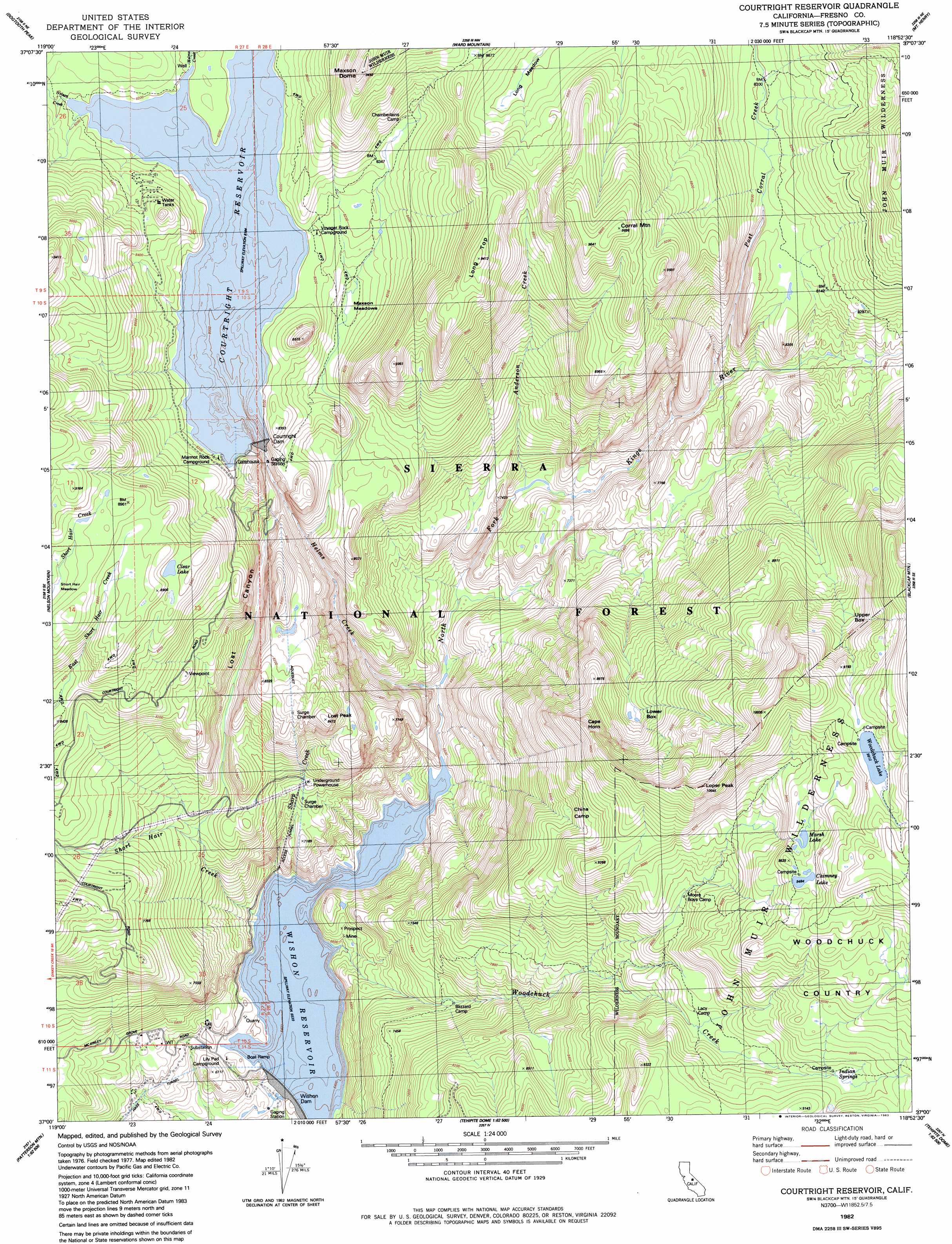
USGS Topo Quad 37118a8 - 1:24,000 scale
| Topo Map Name: | Courtright Reservoir |
| USGS Topo Quad ID: | 37118a8 |
| Print Size: | ca. 21 1/4" wide x 27" high |
| Southeast Coordinates: | 37° N latitude / 118.875° W longitude |
| Map Center Coordinates: | 37.0625° N latitude / 118.9375° W longitude |
| U.S. State: | CA |
| Filename: | o37118a8.jpg |
| Download Map JPG Image: | Courtright Reservoir topo map 1:24,000 scale |
| Map Type: | Topographic |
| Topo Series: | 7.5´ |
| Map Scale: | 1:24,000 |
| Source of Map Images: | United States Geological Survey (USGS) |
| Alternate Map Versions: |
Courtright Reservoir CA 1982, updated 1983 Download PDF Buy paper map Courtright Reservoir CA 1982, updated 1983 Download PDF Buy paper map Courtright Reservoir CA 1982, updated 1983 Download PDF Buy paper map Courtright Reservoir CA 1982, updated 1983 Download PDF Buy paper map Courtright Reservoir CA 2004, updated 2007 Download PDF Buy paper map Courtright Reservoir CA 2012 Download PDF Buy paper map Courtright Reservoir CA 2015 Download PDF Buy paper map |
| FStopo: | US Forest Service topo Courtright Reservoir is available: Download FStopo PDF Download FStopo TIF |
1:24,000 Topo Quads surrounding Courtright Reservoir
Kaiser Peak |
Mount Givens |
Florence Lake |
Mount Hilgard |
Mount Tom |
Huntington Lake |
Dogtooth Peak |
Ward Mountain |
Mount Henry |
Mount Darwin |
Dinkey Creek |
Nelson Mountain |
Courtright Reservoir |
Blackcap Mountain |
Mount Goddard |
Sacate Ridge |
Patterson Mountain |
Rough Spur |
Tehipite Dome |
Slide Bluffs |
Luckett Mountain |
Verplank Ridge |
Hume |
Wren Peak |
Cedar Grove |
> Back to 37118a1 at 1:100,000 scale
> Back to 37118a1 at 1:250,000 scale
> Back to U.S. Topo Maps home
Courtright Reservoir topo map: Gazetteer
Courtright Reservoir: Areas
China Camp elevation 2612m 8569′Woodchuck Country elevation 2884m 9461′
Courtright Reservoir: Basins
Lower Box elevation 2505m 8218′Upper Box elevation 2799m 9183′
Courtright Reservoir: Dams
Courtright Dam elevation 2494m 8182′Courtwright 97-119 Dam elevation 2365m 7759′
Wishon 97-118 Dam elevation 1926m 6318′
Wishon Dam elevation 1973m 6473′
Courtright Reservoir: Flats
Coolidge Meadow elevation 2228m 7309′Maxson Meadows elevation 2497m 8192′
Courtright Reservoir: Lakes
Chimney Lake elevation 2892m 9488′Clear Lake elevation 2679m 8789′
Marsh Lake elevation 2876m 9435′
Woodchuck Lake elevation 3002m 9849′
Courtright Reservoir: Parks
Courtright Intrusive Contact Zone Geological Area elevation 2414m 7919′Courtright Reservoir: Reservoirs
Courtright Reservoir elevation 2494m 8182′Wishon Reservoir elevation 1995m 6545′
Courtright Reservoir: Springs
Indian Springs elevation 2718m 8917′Courtright Reservoir: Streams
Dusy Creek elevation 2496m 8188′Helms Creek elevation 2024m 6640′
Post Corral Creek elevation 2285m 7496′
Sharp Creek elevation 2000m 6561′
Short Hair Creek elevation 1995m 6545′
Woodchuck Creek elevation 2014m 6607′
Courtright Reservoir: Summits
Cape Horn elevation 2867m 9406′Corral Mountain elevation 2940m 9645′
Long Top elevation 2851m 9353′
Loper Peak elevation 3036m 9960′
Lost Peak elevation 2579m 8461′
Maxson Dome elevation 2882m 9455′
Courtright Reservoir: Valleys
Lost Canyon elevation 2275m 7463′Courtright Reservoir digital topo map on disk
Buy this Courtright Reservoir topo map showing relief, roads, GPS coordinates and other geographical features, as a high-resolution digital map file on DVD: