Deep Springs Lake Topo Map California
To zoom in, hover over the map of Deep Springs Lake
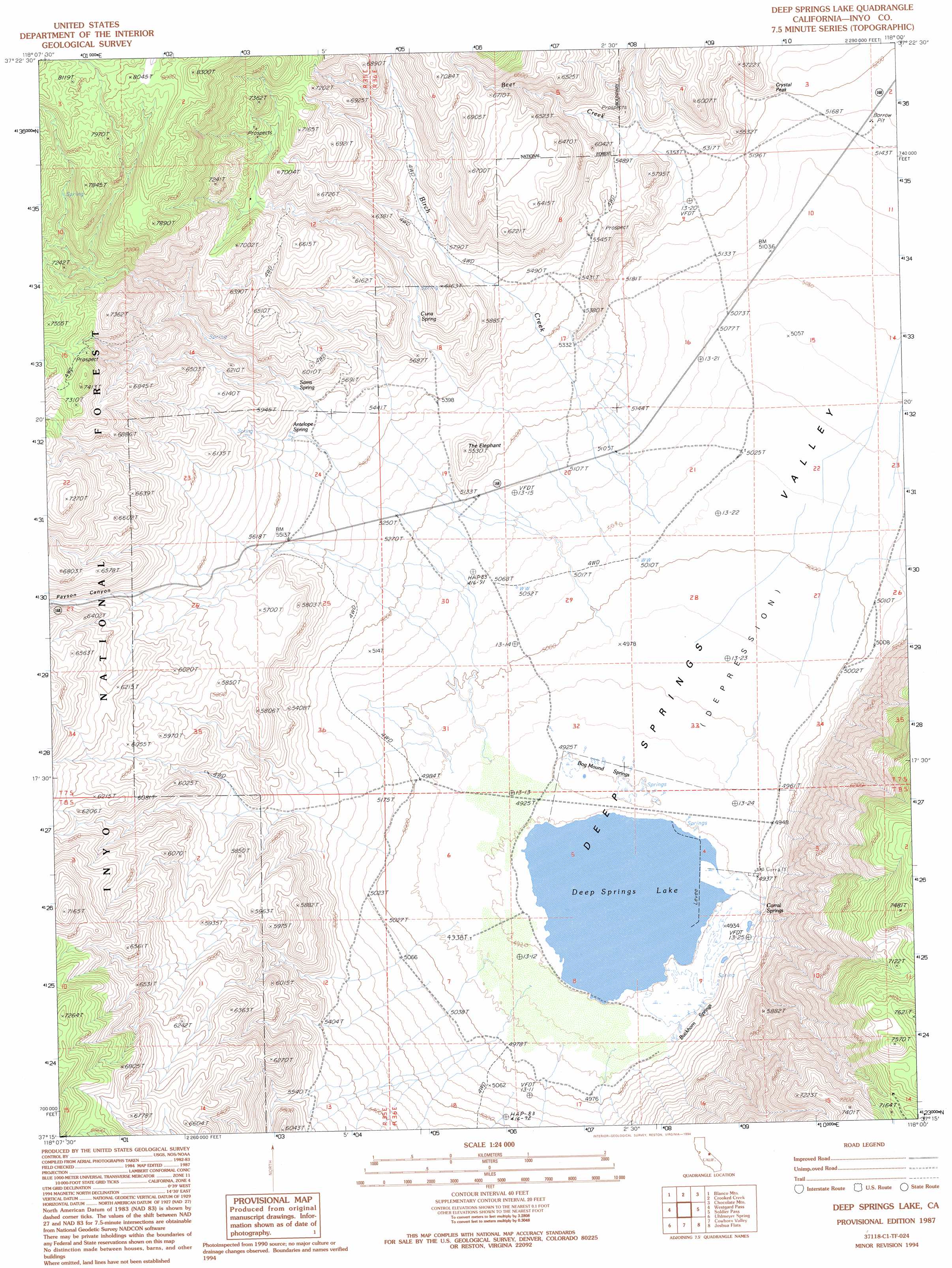
USGS Topo Quad 37118c1 - 1:24,000 scale
| Topo Map Name: | Deep Springs Lake |
| USGS Topo Quad ID: | 37118c1 |
| Print Size: | ca. 21 1/4" wide x 27" high |
| Southeast Coordinates: | 37.25° N latitude / 118° W longitude |
| Map Center Coordinates: | 37.3125° N latitude / 118.0625° W longitude |
| U.S. State: | CA |
| Filename: | o37118c1.jpg |
| Download Map JPG Image: | Deep Springs Lake topo map 1:24,000 scale |
| Map Type: | Topographic |
| Topo Series: | 7.5´ |
| Map Scale: | 1:24,000 |
| Source of Map Images: | United States Geological Survey (USGS) |
| Alternate Map Versions: |
Deep Springs Lake CA 1987, updated 1987 Download PDF Buy paper map Deep Springs Lake CA 1987, updated 1994 Download PDF Buy paper map Deep Springs Lake CA 1994, updated 1997 Download PDF Buy paper map Deep Springs Lake CA 1994, updated 1997 Download PDF Buy paper map Deep Springs Lake CA 2012 Download PDF Buy paper map Deep Springs Lake CA 2015 Download PDF Buy paper map |
| FStopo: | US Forest Service topo Deep Springs Lake is available: Download FStopo PDF Download FStopo TIF |
1:24,000 Topo Quads surrounding Deep Springs Lake
Chalfant Valley |
Mount Barcroft |
Station Peak |
Indian Garden Creek |
Oasis Divide |
Laws |
Blanco Mountain |
Crooked Creek |
Chocolate Mountain |
Sylvania Canyon |
Poleta Canyon |
Westgard Pass |
Deep Springs Lake |
Soldier Pass |
Horse Thief Canyon |
Big Pine |
Uhlmeyer Spring |
Cowhorn Valley |
Joshua Flats |
East Of Joshua Flats |
Fish Springs |
Tinemaha Reservoir |
Waucoba Mountain |
Waucoba Spring |
East Of Waucoba Spring |
> Back to 37118a1 at 1:100,000 scale
> Back to 37118a1 at 1:250,000 scale
> Back to U.S. Topo Maps home
Deep Springs Lake topo map: Gazetteer
Deep Springs Lake: Basins
Deep Springs Valley elevation 1537m 5042′Deep Springs Lake: Lakes
Deep Springs Lake elevation 1494m 4901′Deep Springs Lake: Springs
Antelope Spring elevation 1687m 5534′Bog Mound Springs elevation 1500m 4921′
Buckhorn Springs elevation 1506m 4940′
Corral Springs elevation 1502m 4927′
Cuña Spring elevation 1730m 5675′
Sams Spring elevation 1729m 5672′
Deep Springs Lake: Streams
Beer Creek elevation 1612m 5288′Birch Creek elevation 1533m 5029′
Deep Springs Lake: Summits
Crystal Peak elevation 1630m 5347′The Elephant elevation 1674m 5492′
Deep Springs Lake: Valleys
Payson Canyon elevation 1514m 4967′Deep Springs Lake digital topo map on disk
Buy this Deep Springs Lake topo map showing relief, roads, GPS coordinates and other geographical features, as a high-resolution digital map file on DVD: