Mount Tom Topo Map California
To zoom in, hover over the map of Mount Tom
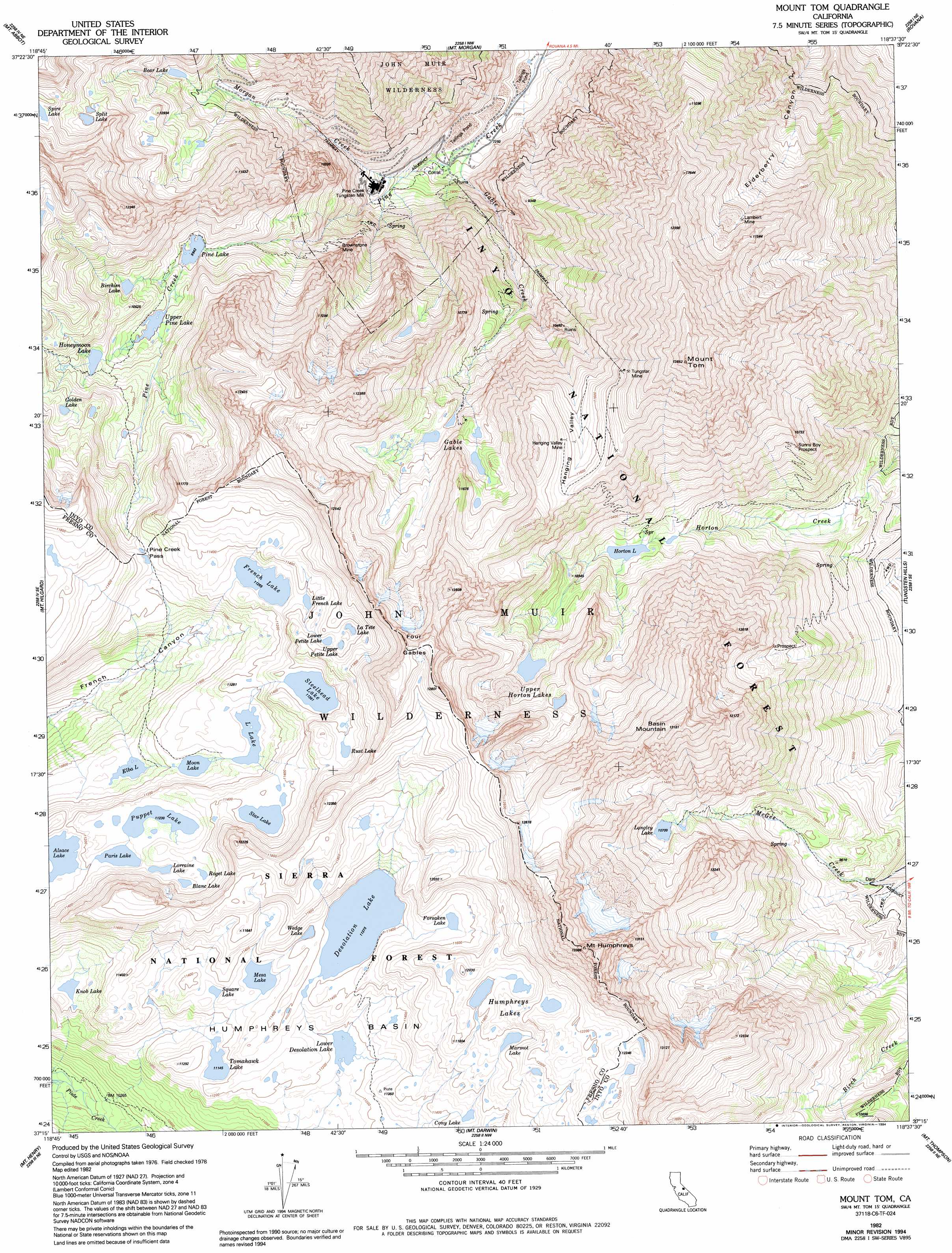
USGS Topo Quad 37118c6 - 1:24,000 scale
| Topo Map Name: | Mount Tom |
| USGS Topo Quad ID: | 37118c6 |
| Print Size: | ca. 21 1/4" wide x 27" high |
| Southeast Coordinates: | 37.25° N latitude / 118.625° W longitude |
| Map Center Coordinates: | 37.3125° N latitude / 118.6875° W longitude |
| U.S. State: | CA |
| Filename: | o37118c6.jpg |
| Download Map JPG Image: | Mount Tom topo map 1:24,000 scale |
| Map Type: | Topographic |
| Topo Series: | 7.5´ |
| Map Scale: | 1:24,000 |
| Source of Map Images: | United States Geological Survey (USGS) |
| Alternate Map Versions: |
Mount Tom CA 1982, updated 1982 Download PDF Buy paper map Mount Tom CA 1982, updated 1994 Download PDF Buy paper map Mount Tom CA 1994, updated 1997 Download PDF Buy paper map Mount Tom CA 2012 Download PDF Buy paper map Mount Tom CA 2015 Download PDF Buy paper map |
| FStopo: | US Forest Service topo Mount Tom is available: Download FStopo PDF Download FStopo TIF |
1:24,000 Topo Quads surrounding Mount Tom
Bloody Mountain |
Convict Lake |
Toms Place |
Casa Diablo Mountain |
Chidago Canyon |
Graveyard Peak |
Mount Abbot |
Mount Morgan |
Rovana |
Fish Slough |
Florence Lake |
Mount Hilgard |
Mount Tom |
Tungsten Hills |
Bishop |
Ward Mountain |
Mount Henry |
Mount Darwin |
Mount Thompson |
Coyote Flat |
Courtright Reservoir |
Blackcap Mountain |
Mount Goddard |
North Palisade |
Split Mountain |
> Back to 37118a1 at 1:100,000 scale
> Back to 37118a1 at 1:250,000 scale
> Back to U.S. Topo Maps home
Mount Tom topo map: Gazetteer
Mount Tom: Basins
Humphreys Basin elevation 3463m 11361′Mount Tom: Dams
Longley 104-031 Dam elevation 3263m 10705′Mount Tom: Gaps
Carol Col elevation 3592m 11784′Pine Creek Pass elevation 3393m 11131′
Mount Tom: Lakes
Alsace Lake elevation 3396m 11141′Bear Lake elevation 3094m 10150′
Birchim Lake elevation 3144m 10314′
Blanc Lake elevation 3449m 11315′
Cony Lake elevation 3496m 11469′
Desolation Lake elevation 3469m 11381′
Elba Lake elevation 3325m 10908′
Forsaken Lake elevation 3520m 11548′
French Lake elevation 3435m 11269′
Gable Lakes elevation 3180m 10433′
Golden Lake elevation 3316m 10879′
Honeymoon Lake elevation 3181m 10436′
Horton Lake elevation 3033m 9950′
Humphreys Lakes elevation 3605m 11827′
Knob Lake elevation 3362m 11030′
La Tete Lake elevation 3509m 11512′
Little French Lake elevation 3461m 11354′
Little Lake elevation 3385m 11105′
Lorraine Lake elevation 3438m 11279′
Lower Desolation Lake elevation 3410m 11187′
Lower Petite Lake elevation 3511m 11519′
Marmot Lake elevation 3584m 11758′
Mesa Lake elevation 3446m 11305′
Moon Lake elevation 3362m 11030′
Paris Lake elevation 3421m 11223′
Pine Lake elevation 3047m 9996′
Puppet Lake elevation 3425m 11236′
Roget Lake elevation 3460m 11351′
Rust Lake elevation 3544m 11627′
Split Lake elevation 3414m 11200′
Square Lake elevation 3450m 11318′
Star Lake elevation 3470m 11384′
Steelhead Lake elevation 3465m 11368′
Tomahawk Lake elevation 3399m 11151′
Upper Horton Lakes elevation 3326m 10912′
Upper Petite Lake elevation 3514m 11528′
Upper Pine Lake elevation 3109m 10200′
Wedge Lake elevation 3476m 11404′
Mount Tom: Mines
Blue Grouse Prospect elevation 2770m 9087′Brownstone Mine elevation 2833m 9294′
Hanging Valley Mine elevation 3646m 11961′
Lakeview Mine elevation 3247m 10652′
Lambert Mine elevation 3321m 10895′
Mountain Basin Prospect elevation 3228m 10590′
Pine Creek Mine elevation 2939m 9642′
Pine Creek Mine-Zero Adit elevation 2906m 9534′
Sunny Boy Prospect elevation 3116m 10223′
Tungstar Mine elevation 3603m 11820′
Mount Tom: Reservoirs
Longley Lake elevation 3268m 10721′Mount Tom: Streams
Gable Creek elevation 2220m 7283′Morgan Creek elevation 2398m 7867′
Mount Tom: Summits
Basin Mountain elevation 3994m 13103′Four Gables elevation 3874m 12709′
Mount Humphreys elevation 4081m 13389′
Mount Tom elevation 4049m 13284′
Mount Tom digital topo map on disk
Buy this Mount Tom topo map showing relief, roads, GPS coordinates and other geographical features, as a high-resolution digital map file on DVD: