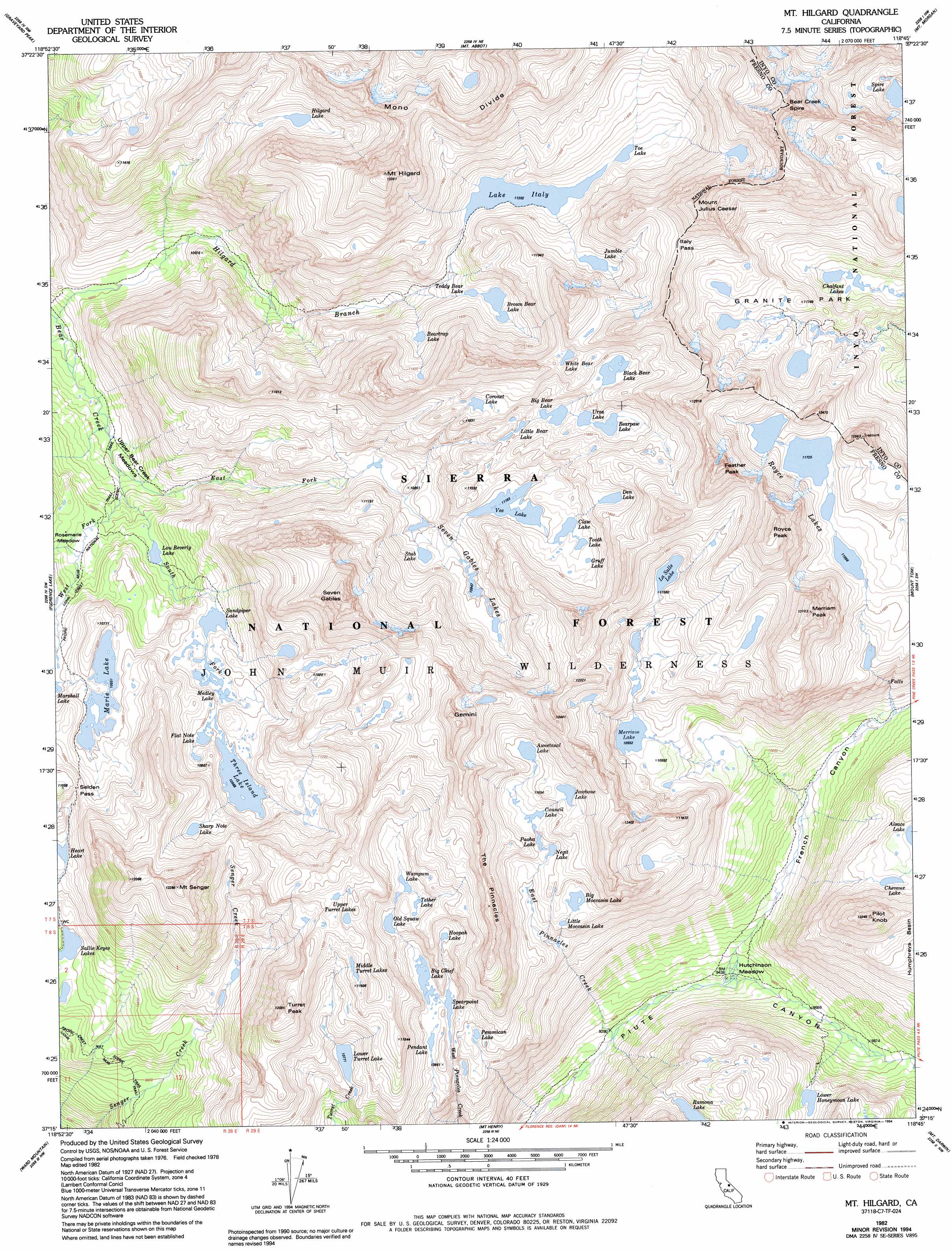
Mount Hilgard Topo Map California
To zoom in, hover over the map of Mount Hilgard
USGS Topo Quad 37118c7 - 1:24,000 scale
| Topo Map Name: | Mount Hilgard |
| USGS Topo Quad ID: | 37118c7 |
| Print Size: | ca. 21 1/4" wide x 27" high |
| Southeast Coordinates: | 37.25° N latitude / 118.75° W longitude |
| Map Center Coordinates: | 37.3125° N latitude / 118.8125° W longitude |
| U.S. State: | CA |
| Filename: | o37118c7.jpg |
| Download Map JPG Image: | Mount Hilgard topo map 1:24,000 scale |
| Map Type: | Topographic |
| Topo Series: | 7.5´ |
| Map Scale: | 1:24,000 |
| Source of Map Images: | United States Geological Survey (USGS) |
| Alternate Map Versions: |
Mt. Hilgard CA 1982, updated 1982 Download PDF Buy paper map Mt. Hilgard CA 1982, updated 1988 Download PDF Buy paper map Mt. Hilgard CA 1982, updated 1994 Download PDF Buy paper map Mount Hilgard CA 2004, updated 2007 Download PDF Buy paper map Mount Hilgard CA 2004, updated 2007 Download PDF Buy paper map Mount Hilgard CA 2012 Download PDF Buy paper map Mount Hilgard CA 2015 Download PDF Buy paper map |
| FStopo: | US Forest Service topo Mount Hilgard is available: Download FStopo PDF Download FStopo TIF |
1:24,000 Topo Quads surrounding Mount Hilgard
Crystal Crag |
Bloody Mountain |
Convict Lake |
Toms Place |
Casa Diablo Mountain |
Sharktooth Peak |
Graveyard Peak |
Mount Abbot |
Mount Morgan |
Rovana |
Mount Givens |
Florence Lake |
Mount Hilgard |
Mount Tom |
Tungsten Hills |
Dogtooth Peak |
Ward Mountain |
Mount Henry |
Mount Darwin |
Mount Thompson |
Nelson Mountain |
Courtright Reservoir |
Blackcap Mountain |
Mount Goddard |
North Palisade |
> Back to 37118a1 at 1:100,000 scale
> Back to 37118a1 at 1:250,000 scale
> Back to U.S. Topo Maps home
Mount Hilgard topo map: Gazetteer
Mount Hilgard: Basins
Granite Park elevation 3535m 11597′Mount Hilgard: Flats
Hutchinson Meadow elevation 2891m 9484′Rosemarie Meadow elevation 3062m 10045′
Upper Bear Creek Meadows elevation 2943m 9655′
Mount Hilgard: Gaps
Italy Pass elevation 3782m 12408′Selden Pass elevation 3313m 10869′
Mount Hilgard: Lakes
Aweetasal Lake elevation 3471m 11387′Bear Paw Lake elevation 3510m 11515′
Beartrap Lake elevation 3389m 11118′
Big Bear Lake elevation 3484m 11430′
Big Chief Lake elevation 3275m 10744′
Big Moccasin Lake elevation 3386m 11108′
Black Bear Lake elevation 3581m 11748′
Brown Bear Lake elevation 3363m 11033′
Chalfant Lakes elevation 3401m 11158′
Chevaux Lake elevation 3376m 11076′
Claw Lake elevation 3432m 11259′
Coronet Lake elevation 3569m 11709′
Council Lake elevation 3421m 11223′
Den Lake elevation 3544m 11627′
Flat Note Lake elevation 3228m 10590′
Gruff Lake elevation 3448m 11312′
Heart Lake elevation 3214m 10544′
Hilgard Lake elevation 3495m 11466′
Hoopal Lake elevation 3353m 11000′
Jawbone Lake elevation 3486m 11437′
Jumble Lake elevation 3520m 11548′
Lake Italy elevation 3416m 11207′
Little Bear Lake elevation 3474m 11397′
Little Moccasin Lake elevation 3358m 11017′
Lou Beverly Lake elevation 3082m 10111′
Lower Honeymoon Lake elevation 3180m 10433′
Lower Turret Lake elevation 3285m 10777′
Marie Lake elevation 3218m 10557′
Medley Lake elevation 3206m 10518′
Merriam Lake elevation 3334m 10938′
Middle Turret Lakes elevation 3491m 11453′
Negit Lake elevation 3397m 11145′
Old Squaw Lake elevation 3349m 10987′
Paoha Lake elevation 3462m 11358′
Pemmican Lake elevation 3281m 10764′
Pendant Lake elevation 3277m 10751′
Royce Lakes elevation 3576m 11732′
Sallie Keyes Lakes elevation 3108m 10196′
Sandpiper Lake elevation 3203m 10508′
Seven Gables Lakes elevation 3342m 10964′
Sharp Note Lake elevation 3340m 10958′
Spearpoint Lake elevation 3273m 10738′
Spire Lake elevation 3520m 11548′
Stub Lake elevation 3315m 10875′
Teddy Bear Lake elevation 3362m 11030′
Tether Lake elevation 3387m 11112′
Three Island Lake elevation 3223m 10574′
Toe Lake elevation 3423m 11230′
Tooth Lake elevation 3439m 11282′
Upper Turret Lakes elevation 3563m 11689′
Ursa Lake elevation 3508m 11509′
Vee Lake elevation 3405m 11171′
Wampum Lake elevation 3371m 11059′
White Bear Lake elevation 3630m 11909′
Mount Hilgard: Ridges
Mono Divide elevation 3749m 12299′The Pinnacles elevation 3689m 12103′
Mount Hilgard: Streams
East Fork Bear Creek elevation 2948m 9671′East Pinnacles Creek elevation 2829m 9281′
South Fork Bear Creek elevation 2954m 9691′
West Fork Bear Creek elevation 2948m 9671′
Mount Hilgard: Summits
Bear Creek Spire elevation 4186m 13733′Feather Peak elevation 4027m 13211′
Gemini elevation 3874m 12709′
Merriam Peak elevation 3951m 12962′
Mount Hilgard elevation 4060m 13320′
Mount Julius Caesar elevation 4022m 13195′
Mount Seneger elevation 3736m 12257′
Pilot Knob elevation 3725m 12221′
Royce Peak elevation 4047m 13277′
Seven Gables elevation 3963m 13001′
Turret Peak elevation 3662m 12014′
Mount Hilgard: Valleys
French Canyon elevation 2874m 9429′Mount Hilgard digital topo map on disk
Buy this Mount Hilgard topo map showing relief, roads, GPS coordinates and other geographical features, as a high-resolution digital map file on DVD: