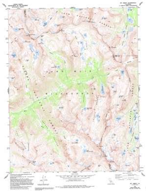
Mount Abbot Topo Map California
To zoom in, hover over the map of Mount Abbot
USGS Topo Quad 37118d7 - 1:24,000 scale
| Topo Map Name: | Mount Abbot |
| USGS Topo Quad ID: | 37118d7 |
| Print Size: | ca. 21 1/4" wide x 27" high |
| Southeast Coordinates: | 37.375° N latitude / 118.75° W longitude |
| Map Center Coordinates: | 37.4375° N latitude / 118.8125° W longitude |
| U.S. State: | CA |
| Filename: | o37118d7.jpg |
| Download Map JPG Image: | Mount Abbot topo map 1:24,000 scale |
| Map Type: | Topographic |
| Topo Series: | 7.5´ |
| Map Scale: | 1:24,000 |
| Source of Map Images: | United States Geological Survey (USGS) |
| Alternate Map Versions: |
Mt. Abbot CA 1982, updated 1982 Download PDF Buy paper map Mt. Abbot CA 1982, updated 1994 Download PDF Buy paper map Mt. Abbot CA 1982, updated 1994 Download PDF Buy paper map Mount Abbot CA 2004, updated 2007 Download PDF Buy paper map Mount Abbot CA 2004, updated 2007 Download PDF Buy paper map Mount Abbot CA 2012 Download PDF Buy paper map Mount Abbot CA 2015 Download PDF Buy paper map |
| FStopo: | US Forest Service topo Mount Abbot is available: Download FStopo PDF Download FStopo TIF |
1:24,000 Topo Quads surrounding Mount Abbot
> Back to 37118a1 at 1:100,000 scale
> Back to 37118a1 at 1:250,000 scale
> Back to U.S. Topo Maps home
Mount Abbot topo map: Gazetteer
Mount Abbot: Basins
Pioneer Basin elevation 3360m 11023′Mount Abbot: Gaps
Gabbot Pass elevation 3740m 12270′Hopkins Pass elevation 3487m 11440′
Mono Pass elevation 3680m 12073′
Morgan Pass elevation 3387m 11112′
Mount Abbot: Lakes
Big McGee Lake elevation 3194m 10479′Box Lake elevation 3198m 10492′
Chickenfoot Lake elevation 3290m 10793′
Crocker Lake elevation 3315m 10875′
Dade Lake elevation 3533m 11591′
First Recess Lakes elevation 3365m 11040′
Fourth Recess Lake elevation 3090m 10137′
Frog Lake elevation 3186m 10452′
Gem Lakes elevation 3336m 10944′
Golden Lake elevation 3168m 10393′
Golden Lake elevation 3353m 11000′
Grinnell Lake elevation 3305m 10843′
Heart Lake elevation 3181m 10436′
Hidden Lakes elevation 3204m 10511′
Hilton Creek Lakes elevation 3263m 10705′
Laurel Lake elevation 3144m 10314′
Little Grinnell Lake elevation 3382m 11095′
Little Lakes elevation 3294m 10807′
Little McGee Lake elevation 3363m 11033′
Long Lake elevation 3218m 10557′
Lower Hopkins Lake elevation 3158m 10360′
Lower Mills Creek Lake elevation 3309m 10856′
Mack Lake elevation 3158m 10360′
Marsh Lake elevation 3178m 10426′
Mills Lake elevation 3556m 11666′
Mist Lake elevation 3334m 10938′
Neelle Lake elevation 3462m 11358′
Pioneer Basin Lakes elevation 3313m 10869′
Red and White Lake elevation 3359m 11020′
Ross Finch Lake elevation 3291m 10797′
Ruby Lake elevation 3392m 11128′
Snow Lakes elevation 3476m 11404′
Stanford Lake elevation 3488m 11443′
Steelhead Lake elevation 3161m 10370′
Summit Lake elevation 3627m 11899′
Third Recess Lake elevation 3212m 10538′
Trail Lakes elevation 3417m 11210′
Treasure Lakes elevation 3412m 11194′
Upper Hopkins Lakes elevation 3316m 10879′
Upper Mills Creek Lake elevation 3406m 11174′
Mount Abbot: Streams
Golden Creek elevation 2988m 9803′Hopkins Creek elevation 2803m 9196′
Laurel Creek elevation 2680m 8792′
Mills Creek elevation 2595m 8513′
Mount Abbot: Summits
Mono Rock elevation 3479m 11414′Mount Abbot elevation 4176m 13700′
Mount Crocker elevation 3741m 12273′
Mount Dade elevation 4115m 13500′
Mount Gabb elevation 4168m 13674′
Mount Hopkins elevation 3721m 12208′
Mount Huntington elevation 3766m 12355′
Mount Mills elevation 4035m 13238′
Mount Stanford elevation 3908m 12821′
Mount Starr elevation 3906m 12814′
Recess Peak elevation 3885m 12746′
Red and White Mountain elevation 3908m 12821′
Mount Abbot: Valleys
First Recess elevation 2562m 8405′Fourth Recess elevation 3056m 10026′
Second Recess elevation 2611m 8566′
Third Recess elevation 2931m 9616′
Mount Abbot digital topo map on disk
Buy this Mount Abbot topo map showing relief, roads, GPS coordinates and other geographical features, as a high-resolution digital map file on DVD:


