Auberry Topo Map California
To zoom in, hover over the map of Auberry
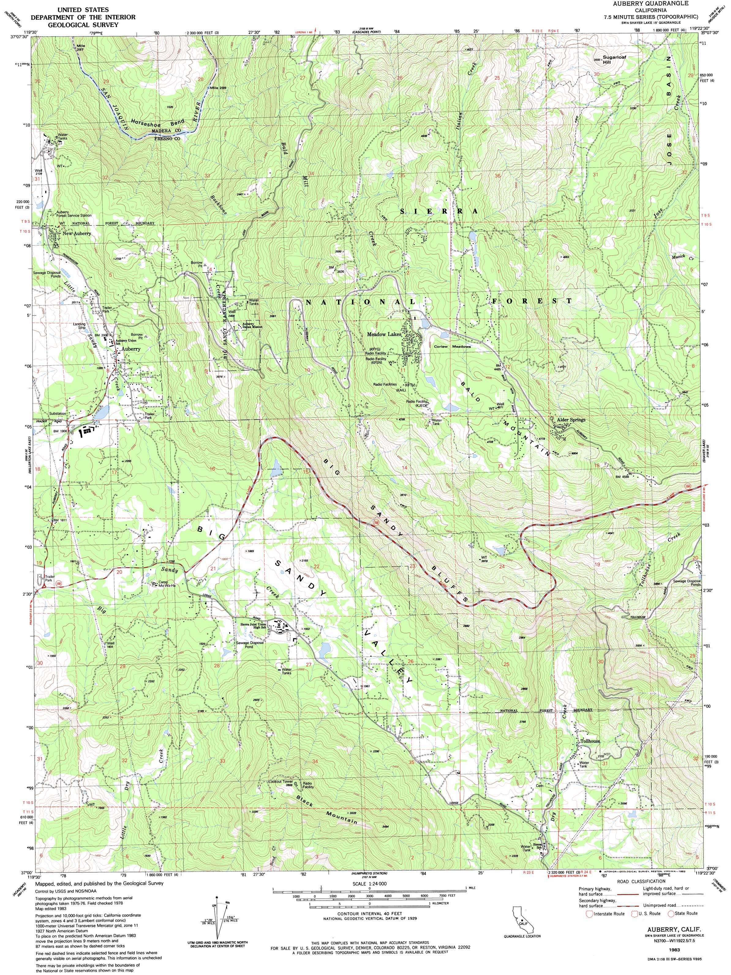
USGS Topo Quad 37119a4 - 1:24,000 scale
| Topo Map Name: | Auberry |
| USGS Topo Quad ID: | 37119a4 |
| Print Size: | ca. 21 1/4" wide x 27" high |
| Southeast Coordinates: | 37° N latitude / 119.375° W longitude |
| Map Center Coordinates: | 37.0625° N latitude / 119.4375° W longitude |
| U.S. State: | CA |
| Filename: | o37119a4.jpg |
| Download Map JPG Image: | Auberry topo map 1:24,000 scale |
| Map Type: | Topographic |
| Topo Series: | 7.5´ |
| Map Scale: | 1:24,000 |
| Source of Map Images: | United States Geological Survey (USGS) |
| Alternate Map Versions: |
Auberry CA 1983, updated 1983 Download PDF Buy paper map Auberry CA 2004, updated 2007 Download PDF Buy paper map Auberry CA 2012 Download PDF Buy paper map Auberry CA 2015 Download PDF Buy paper map |
| FStopo: | US Forest Service topo Auberry is available: Download FStopo PDF Download FStopo TIF |
1:24,000 Topo Quads surrounding Auberry
Ahwahnee |
Bass Lake |
Shuteye Peak |
Mammoth Pool Dam |
Kaiser Peak |
O'Neals |
North Fork |
Cascadel Point |
Musick Mountain |
Huntington Lake |
Millerton Lake West |
Millerton Lake East |
Auberry |
Shaver Lake |
Dinkey Creek |
Friant |
Academy |
Humphreys Station |
Trimmer |
Sacate Ridge |
Clovis |
Round Mountain |
Piedra |
Pine Flat Dam |
Luckett Mountain |
> Back to 37119a1 at 1:100,000 scale
> Back to 37118a1 at 1:250,000 scale
> Back to U.S. Topo Maps home
Auberry topo map: Gazetteer
Auberry: Airports
Auberry Hydro Service Center Heliport elevation 619m 2030′Auberry: Areas
Backbone Creek Research Natural Area elevation 766m 2513′Carpenteria Botanical Area elevation 1161m 3809′
Auberry: Basins
Jose Basin elevation 1024m 3359′Auberry: Bends
Horseshoe Bend elevation 342m 1122′Auberry: Cliffs
Big Sandy Bluff elevation 781m 2562′Auberry: Flats
Corlew Meadows elevation 1351m 4432′Auberry: Populated Places
Alder Springs elevation 1349m 4425′Auberry elevation 615m 2017′
Meadow Lakes elevation 1357m 4452′
New Auberry elevation 629m 2063′
Tollhouse elevation 585m 1919′
Auberry: Post Offices
Auberry Post Office elevation 601m 1971′Auberry: Streams
Backbone Creek elevation 339m 1112′Bald Mill Creek elevation 340m 1115′
Musick Creek elevation 1014m 3326′
Tollhouse Creek elevation 963m 3159′
Auberry: Summits
Backbone Mountain elevation 928m 3044′Bald Mountain elevation 1466m 4809′
Black Mountain elevation 1093m 3585′
Sugarloaf Hill elevation 1031m 3382′
Auberry digital topo map on disk
Buy this Auberry topo map showing relief, roads, GPS coordinates and other geographical features, as a high-resolution digital map file on DVD: