Daulton Topo Map California
To zoom in, hover over the map of Daulton
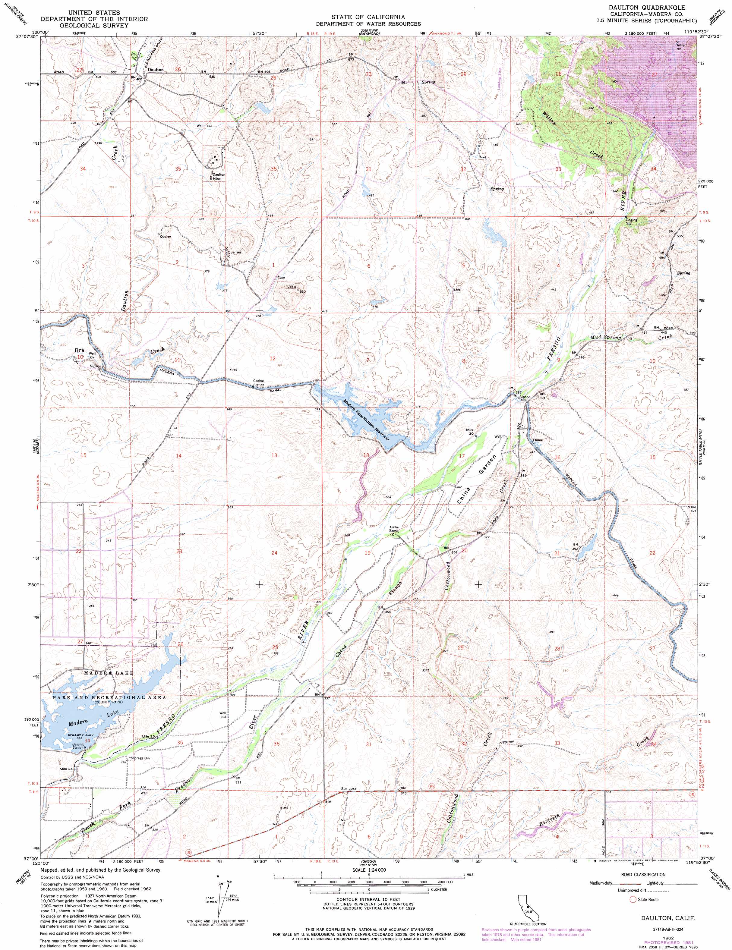
USGS Topo Quad 37119a8 - 1:24,000 scale
| Topo Map Name: | Daulton |
| USGS Topo Quad ID: | 37119a8 |
| Print Size: | ca. 21 1/4" wide x 27" high |
| Southeast Coordinates: | 37° N latitude / 119.875° W longitude |
| Map Center Coordinates: | 37.0625° N latitude / 119.9375° W longitude |
| U.S. State: | CA |
| Filename: | o37119a8.jpg |
| Download Map JPG Image: | Daulton topo map 1:24,000 scale |
| Map Type: | Topographic |
| Topo Series: | 7.5´ |
| Map Scale: | 1:24,000 |
| Source of Map Images: | United States Geological Survey (USGS) |
| Alternate Map Versions: |
Daulton CA 1942, updated 1954 Download PDF Buy paper map Daulton CA 1962, updated 1963 Download PDF Buy paper map Daulton CA 1962, updated 1977 Download PDF Buy paper map Daulton CA 1962, updated 1981 Download PDF Buy paper map Daulton CA 1962, updated 1981 Download PDF Buy paper map Daulton CA 1962, updated 1991 Download PDF Buy paper map Daulton CA 2012 Download PDF Buy paper map Daulton CA 2015 Download PDF Buy paper map |
1:24,000 Topo Quads surrounding Daulton
Owens Reservoir |
Illinois Hill |
Ben Hur |
Horsecamp Mountain |
Ahwahnee |
Le Grand |
Raynor Creek |
Raymond |
Knowles |
O'Neals |
Berenda |
Kismet |
Daulton |
Little Table Mountain |
Millerton Lake West |
Bonita Ranch |
Madera |
Gregg |
Lanes Bridge |
Friant |
Gravelly Ford |
Biola |
Herndon |
Fresno North |
Clovis |
> Back to 37119a1 at 1:100,000 scale
> Back to 37118a1 at 1:250,000 scale
> Back to U.S. Topo Maps home
Daulton topo map: Gazetteer
Daulton: Airports
Daulton Airport elevation 126m 413′Yosemite Hidden Lake Ranch Airport elevation 148m 485′
Daulton: Bridges
Hensley Bridge elevation 165m 541′Hensley Bridge (historical) elevation 165m 541′
Daulton: Canals
Madera Canal elevation 126m 413′Daulton: Dams
Hidden Dam elevation 153m 501′Madera Lake 1-038 Dam elevation 100m 328′
Daulton: Flats
China Garden elevation 112m 367′Daulton: Guts
China Slough elevation 101m 331′Daulton: Mines
Buchanan Mine elevation 139m 456′Daulton Mine elevation 137m 449′
Daulton: Parks
Hensley Lake Recreation Area elevation 165m 541′Madera Lake Park and Recreational Area elevation 104m 341′
Daulton: Populated Places
Daulton elevation 123m 403′Lake Madera Country Estates elevation 106m 347′
Daulton: Reservoirs
Hensley Lake elevation 153m 501′Madera Equalization Reservoir elevation 114m 374′
Madera Lake elevation 100m 328′
Daulton: Streams
Daulton Creek elevation 101m 331′Mud Spring Creek elevation 117m 383′
Willow Creek elevation 119m 390′
Daulton digital topo map on disk
Buy this Daulton topo map showing relief, roads, GPS coordinates and other geographical features, as a high-resolution digital map file on DVD: