North Fork Topo Map California
To zoom in, hover over the map of North Fork
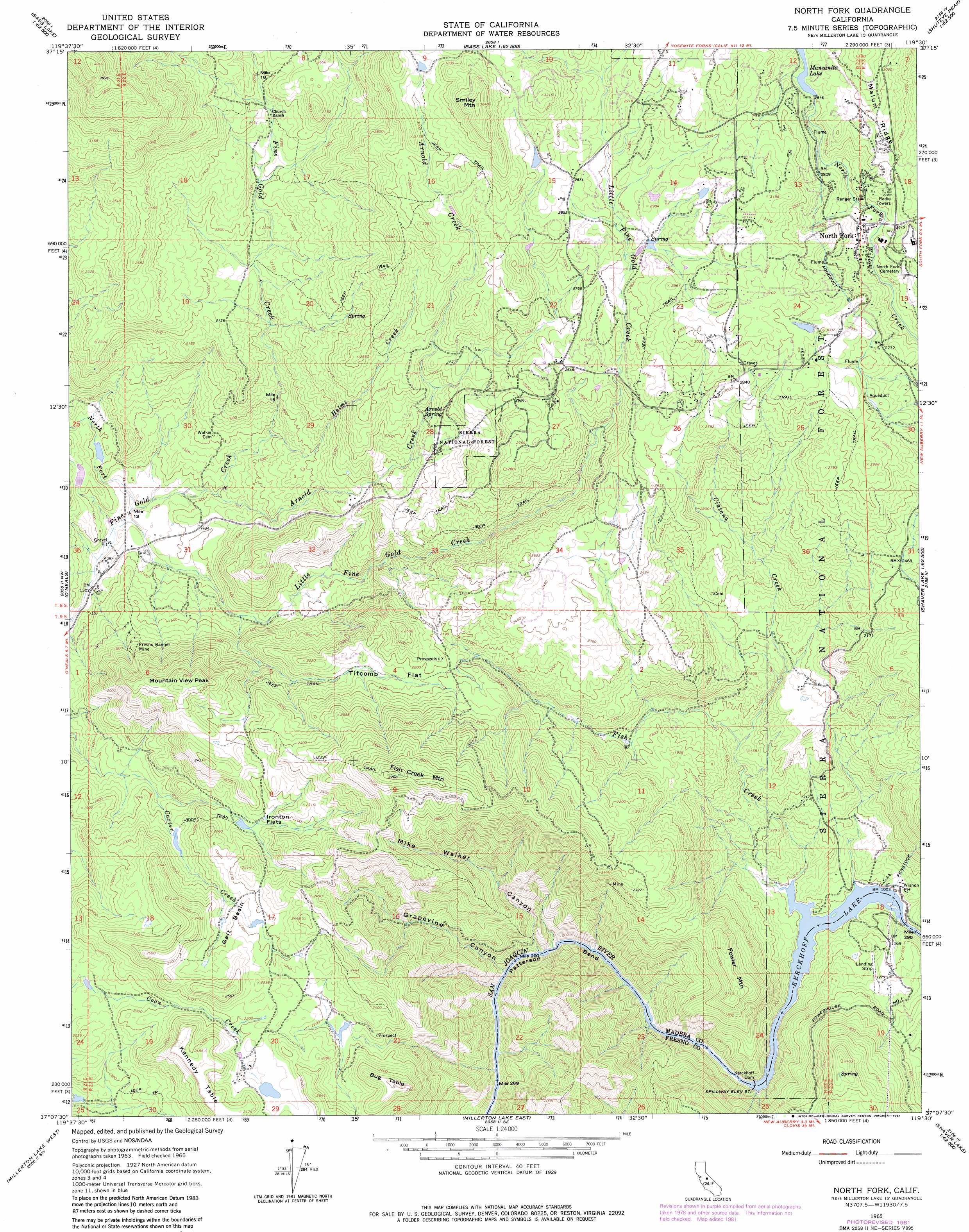
USGS Topo Quad 37119b5 - 1:24,000 scale
| Topo Map Name: | North Fork |
| USGS Topo Quad ID: | 37119b5 |
| Print Size: | ca. 21 1/4" wide x 27" high |
| Southeast Coordinates: | 37.125° N latitude / 119.5° W longitude |
| Map Center Coordinates: | 37.1875° N latitude / 119.5625° W longitude |
| U.S. State: | CA |
| Filename: | o37119b5.jpg |
| Download Map JPG Image: | North Fork topo map 1:24,000 scale |
| Map Type: | Topographic |
| Topo Series: | 7.5´ |
| Map Scale: | 1:24,000 |
| Source of Map Images: | United States Geological Survey (USGS) |
| Alternate Map Versions: |
North Fork CA 1965, updated 1966 Download PDF Buy paper map North Fork CA 1965, updated 1981 Download PDF Buy paper map North Fork CA 2004, updated 2007 Download PDF Buy paper map North Fork CA 2012 Download PDF Buy paper map North Fork CA 2015 Download PDF Buy paper map |
| FStopo: | US Forest Service topo North Fork is available: Download FStopo PDF Download FStopo TIF |
1:24,000 Topo Quads surrounding North Fork
Stumpfield Mountain |
Fish Camp |
White Chief Mountain |
Little Shuteye Peak |
Squaw Dome |
Horsecamp Mountain |
Ahwahnee |
Bass Lake |
Shuteye Peak |
Mammoth Pool Dam |
Knowles |
O'Neals |
North Fork |
Cascadel Point |
Musick Mountain |
Little Table Mountain |
Millerton Lake West |
Millerton Lake East |
Auberry |
Shaver Lake |
Lanes Bridge |
Friant |
Academy |
Humphreys Station |
Trimmer |
> Back to 37119a1 at 1:100,000 scale
> Back to 37118a1 at 1:250,000 scale
> Back to U.S. Topo Maps home
North Fork topo map: Gazetteer
North Fork: Basins
Galt Basin elevation 675m 2214′North Fork: Dams
Kerckhoff Dam elevation 300m 984′Number 2 Reservoir 95-012 Dam elevation 850m 2788′
North Fork: Flats
Ironton Flats elevation 633m 2076′Titcomb Flat elevation 648m 2125′
North Fork: Mines
Fresno Banner Mine elevation 553m 1814′North Fork: Populated Places
Fine Gold elevation 412m 1351′North Fork elevation 804m 2637′
North Fork: Post Offices
North Fork Post Office elevation 804m 2637′North Fork: Reservoirs
Kerckhoff Lake elevation 300m 984′Manzanita Lake elevation 850m 2788′
North Fork: Ridges
Malum Ridge elevation 904m 2965′North Fork: Springs
Arnold Spring elevation 659m 2162′North Fork: Streams
Arnold Creek elevation 420m 1377′Ciatana Creek elevation 449m 1473′
Fish Creek elevation 302m 990′
Helms Creek elevation 476m 1561′
Little Fine Gold Creek elevation 390m 1279′
North Fork Fine Gold Creek elevation 390m 1279′
North Fork: Summits
Bug Table elevation 797m 2614′Fish Creek Mountain elevation 997m 3270′
Fowler Mountain elevation 656m 2152′
Kennedy Table elevation 758m 2486′
Mountain View Peak elevation 782m 2565′
Smiley Mountain elevation 1082m 3549′
North Fork: Valleys
Grapevine Canyon elevation 260m 853′Mike Walker Canyon elevation 259m 849′
North Fork digital topo map on disk
Buy this North Fork topo map showing relief, roads, GPS coordinates and other geographical features, as a high-resolution digital map file on DVD: