Kaiser Peak Topo Map California
To zoom in, hover over the map of Kaiser Peak
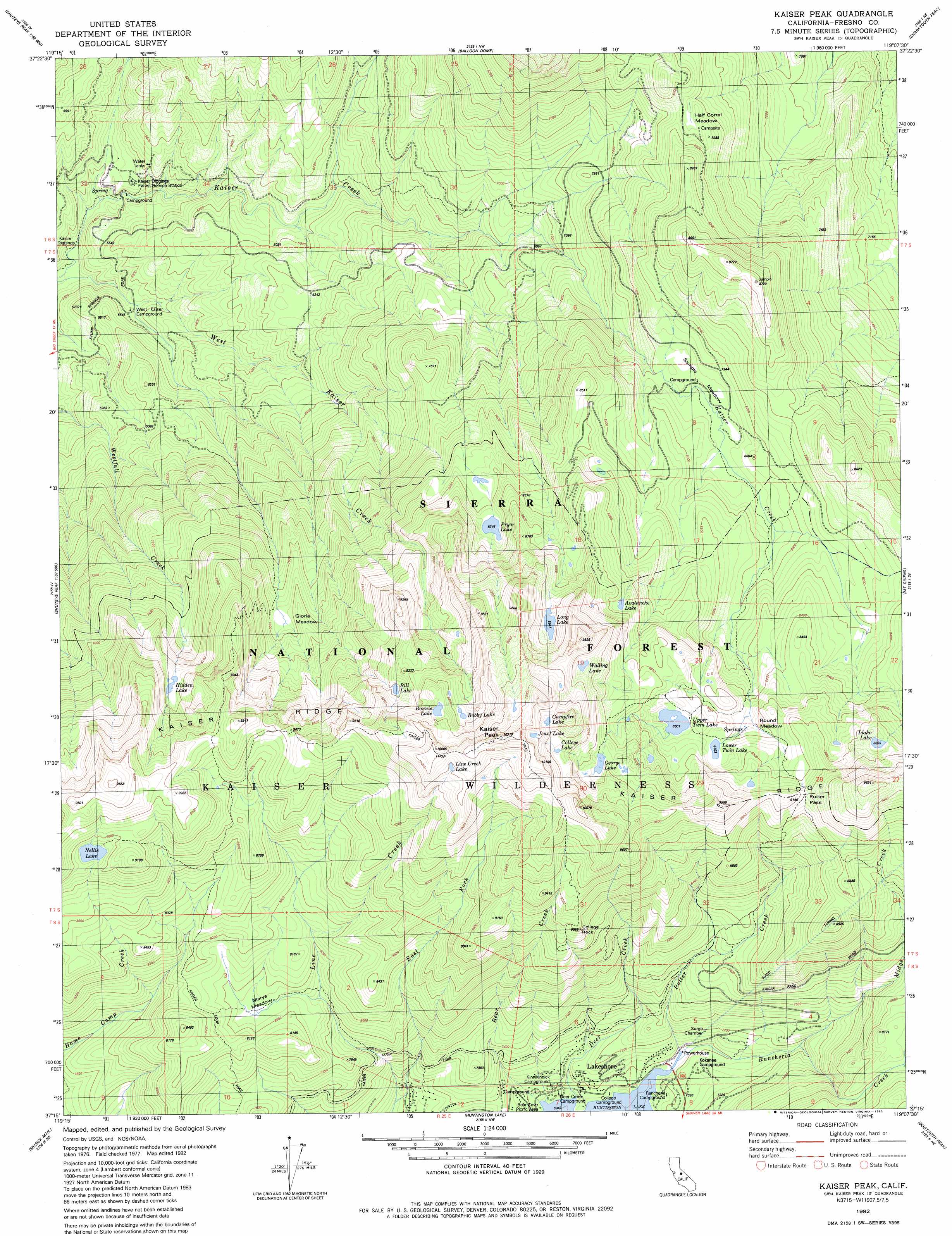
USGS Topo Quad 37119c2 - 1:24,000 scale
| Topo Map Name: | Kaiser Peak |
| USGS Topo Quad ID: | 37119c2 |
| Print Size: | ca. 21 1/4" wide x 27" high |
| Southeast Coordinates: | 37.25° N latitude / 119.125° W longitude |
| Map Center Coordinates: | 37.3125° N latitude / 119.1875° W longitude |
| U.S. State: | CA |
| Filename: | o37119c2.jpg |
| Download Map JPG Image: | Kaiser Peak topo map 1:24,000 scale |
| Map Type: | Topographic |
| Topo Series: | 7.5´ |
| Map Scale: | 1:24,000 |
| Source of Map Images: | United States Geological Survey (USGS) |
| Alternate Map Versions: |
Kaiser Peak CA 1982, updated 1982 Download PDF Buy paper map Kaiser Peak CA 1982, updated 1983 Download PDF Buy paper map Kaiser Peak CA 1982, updated 1983 Download PDF Buy paper map Kaiser Peak CA 2004, updated 2007 Download PDF Buy paper map Kaiser Peak CA 2004, updated 2007 Download PDF Buy paper map Kaiser Peak CA 2012 Download PDF Buy paper map Kaiser Peak CA 2015 Download PDF Buy paper map |
| FStopo: | US Forest Service topo Kaiser Peak is available: Download FStopo PDF Download FStopo TIF |
1:24,000 Topo Quads surrounding Kaiser Peak
Sing Peak |
Timber Knob |
Cattle Mountain |
Crystal Crag |
Bloody Mountain |
Little Shuteye Peak |
Squaw Dome |
Balloon Dome |
Sharktooth Peak |
Graveyard Peak |
Shuteye Peak |
Mammoth Pool Dam |
Kaiser Peak |
Mount Givens |
Florence Lake |
Cascadel Point |
Musick Mountain |
Huntington Lake |
Dogtooth Peak |
Ward Mountain |
Auberry |
Shaver Lake |
Dinkey Creek |
Nelson Mountain |
Courtright Reservoir |
> Back to 37119a1 at 1:100,000 scale
> Back to 37118a1 at 1:250,000 scale
> Back to U.S. Topo Maps home
Kaiser Peak topo map: Gazetteer
Kaiser Peak: Flats
Gloria Meadow elevation 2355m 7726′Marys Meadow elevation 2424m 7952′
Round Meadow elevation 2590m 8497′
Sample Meadows elevation 2401m 7877′
Kaiser Peak: Gaps
Potter Pass elevation 2735m 8973′Kaiser Peak: Lakes
Avalanche Lake elevation 2667m 8750′Bill Lake elevation 2744m 9002′
Bobby Lake elevation 2851m 9353′
Bonnie Lake elevation 2909m 9543′
Campfire Lake elevation 2958m 9704′
College Lake elevation 2899m 9511′
George Lake elevation 2776m 9107′
Hidden Lake elevation 2543m 8343′
Idaho Lake elevation 2704m 8871′
Jewel Lake elevation 2996m 9829′
Line Creek Lake elevation 2984m 9790′
Long Lake elevation 2726m 8943′
Lower Twin Lake elevation 2629m 8625′
Nellie Lake elevation 2713m 8900′
Pryor Lake elevation 2519m 8264′
Upper Twin Lake elevation 2623m 8605′
Walling Lake elevation 2829m 9281′
Kaiser Peak: Mines
Kaiser Diggings elevation 1622m 5321′Kaiser Peak: Parks
Kaiser Park elevation 3125m 10252′Kaiser Peak: Pillars
College Rock elevation 2759m 9051′Kaiser Peak: Populated Places
Lakeshore elevation 2132m 6994′Snow Bend elevation 2429m 7969′
Kaiser Peak: Post Offices
Lakeshore Post Office (historical) elevation 2132m 6994′Kaiser Peak: Streams
Deer Creek elevation 2119m 6952′Midge Creek elevation 2181m 7155′
Potter Creek elevation 2118m 6948′
Rancheria Creek elevation 2118m 6948′
Kaiser Peak: Summits
Kaiser Peak elevation 3007m 9865′Kaiser Peak digital topo map on disk
Buy this Kaiser Peak topo map showing relief, roads, GPS coordinates and other geographical features, as a high-resolution digital map file on DVD: