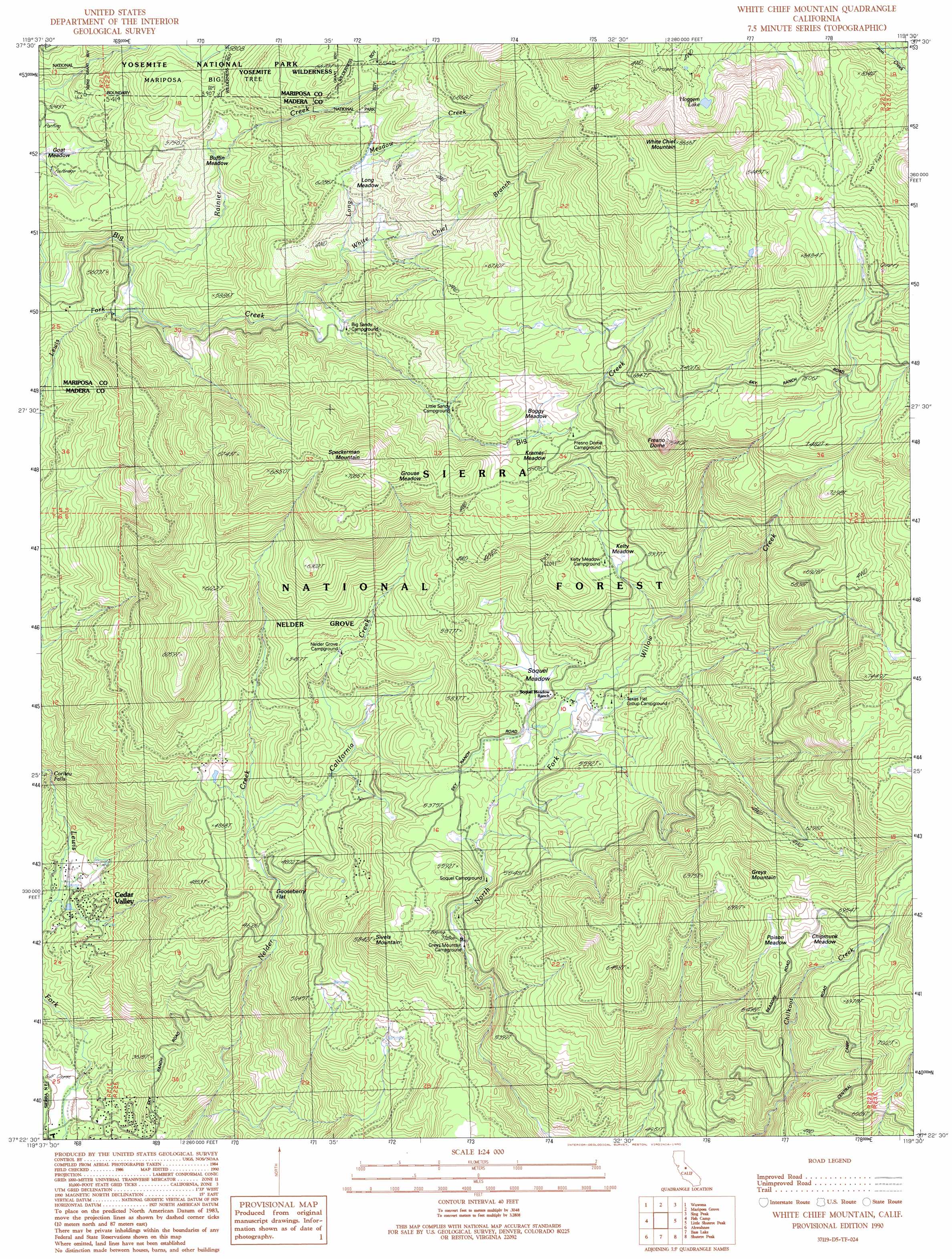
White Chief Mountain Topo Map California
To zoom in, hover over the map of White Chief Mountain
USGS Topo Quad 37119d5 - 1:24,000 scale
| Topo Map Name: | White Chief Mountain |
| USGS Topo Quad ID: | 37119d5 |
| Print Size: | ca. 21 1/4" wide x 27" high |
| Southeast Coordinates: | 37.375° N latitude / 119.5° W longitude |
| Map Center Coordinates: | 37.4375° N latitude / 119.5625° W longitude |
| U.S. State: | CA |
| Filename: | o37119d5.jpg |
| Download Map JPG Image: | White Chief Mountain topo map 1:24,000 scale |
| Map Type: | Topographic |
| Topo Series: | 7.5´ |
| Map Scale: | 1:24,000 |
| Source of Map Images: | United States Geological Survey (USGS) |
| Alternate Map Versions: |
White Chief Mountain CA 1990, updated 1990 Download PDF Buy paper map White Chief Mountain CA 2004, updated 2007 Download PDF Buy paper map White Chief Mountain CA 2012 Download PDF Buy paper map White Chief Mountain CA 2015 Download PDF Buy paper map |
| FStopo: | US Forest Service topo White Chief Mountain is available: Download FStopo PDF Download FStopo TIF |
1:24,000 Topo Quads surrounding White Chief Mountain
El Portal |
El Capitan |
Half Dome |
Merced Peak |
Mount Lyell |
Buckingham Mountain |
Wawona |
Mariposa Grove |
Sing Peak |
Timber Knob |
Stumpfield Mountain |
Fish Camp |
White Chief Mountain |
Little Shuteye Peak |
Squaw Dome |
Horsecamp Mountain |
Ahwahnee |
Bass Lake |
Shuteye Peak |
Mammoth Pool Dam |
Knowles |
O'Neals |
North Fork |
Cascadel Point |
Musick Mountain |
> Back to 37119a1 at 1:100,000 scale
> Back to 37118a1 at 1:250,000 scale
> Back to U.S. Topo Maps home
White Chief Mountain topo map: Gazetteer
White Chief Mountain: Falls
Corlieu Falls elevation 1115m 3658′White Chief Mountain: Flats
Boggy Meadow elevation 1989m 6525′Buffin Meadow elevation 1752m 5748′
Chipmunk Meadow elevation 2074m 6804′
Goat Meadow elevation 1598m 5242′
Gooseberry Flat elevation 1420m 4658′
Grouse Meadow elevation 2082m 6830′
Kelty Meadow elevation 1786m 5859′
Kramer Meadow elevation 1936m 6351′
Long Meadow elevation 1957m 6420′
Poison Meadow elevation 2054m 6738′
Soquel Meadow elevation 1639m 5377′
White Chief Mountain: Lakes
Hoggem Lake elevation 2432m 7979′White Chief Mountain: Streams
California Creek elevation 1409m 4622′Long Meadow Creek elevation 1839m 6033′
Rainier Creek elevation 1598m 5242′
White Chief Branch elevation 1768m 5800′
White Chief Mountain: Summits
Fresno Dome elevation 2273m 7457′Goat Meadow Snow Play Mountain elevation 1609m 5278′
Greys Mountain elevation 2158m 7080′
Sivels Mountain elevation 1722m 5649′
Speckerman Mountain elevation 2181m 7155′
White Chief Mountain elevation 2637m 8651′
White Chief Mountain: Woods
Nelder Grove - Giant Sequoias elevation 1918m 6292′White Chief Mountain digital topo map on disk
Buy this White Chief Mountain topo map showing relief, roads, GPS coordinates and other geographical features, as a high-resolution digital map file on DVD: