Mariposa Topo Map California
To zoom in, hover over the map of Mariposa
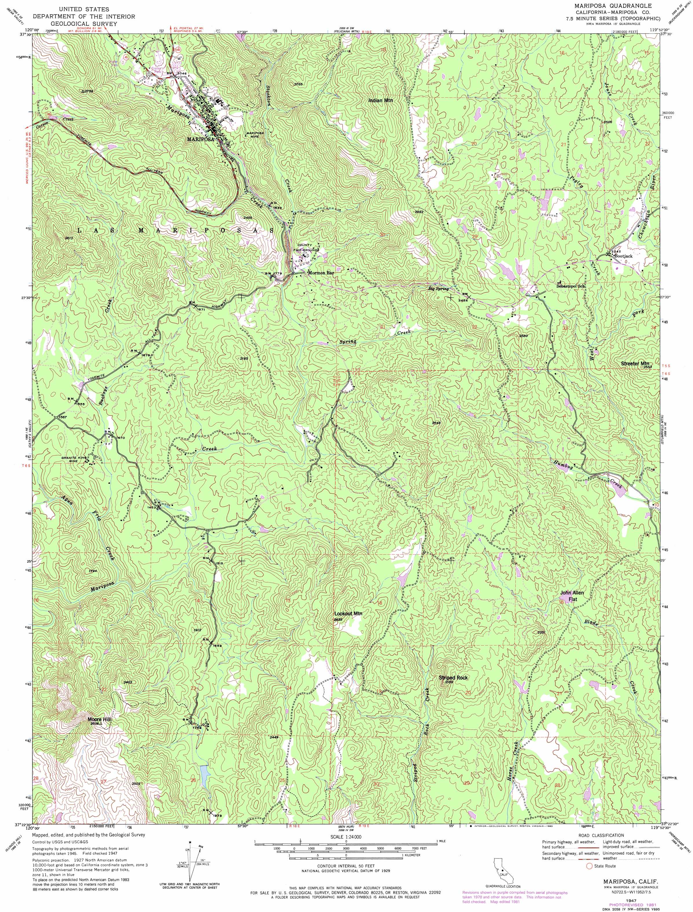
USGS Topo Quad 37119d8 - 1:24,000 scale
| Topo Map Name: | Mariposa |
| USGS Topo Quad ID: | 37119d8 |
| Print Size: | ca. 21 1/4" wide x 27" high |
| Southeast Coordinates: | 37.375° N latitude / 119.875° W longitude |
| Map Center Coordinates: | 37.4375° N latitude / 119.9375° W longitude |
| U.S. State: | CA |
| Filename: | o37119d8.jpg |
| Download Map JPG Image: | Mariposa topo map 1:24,000 scale |
| Map Type: | Topographic |
| Topo Series: | 7.5´ |
| Map Scale: | 1:24,000 |
| Source of Map Images: | United States Geological Survey (USGS) |
| Alternate Map Versions: |
Mariposa CA 1947, updated 1947 Download PDF Buy paper map Mariposa CA 1947, updated 1948 Download PDF Buy paper map Mariposa CA 1947, updated 1971 Download PDF Buy paper map Mariposa CA 1947, updated 1983 Download PDF Buy paper map Mariposa CA 2012 Download PDF Buy paper map Mariposa CA 2015 Download PDF Buy paper map |
1:24,000 Topo Quads surrounding Mariposa
Coulterville |
Buckhorn Peak |
Kinsley |
El Portal |
El Capitan |
Hornitos |
Bear Valley |
Feliciana Mountain |
Buckingham Mountain |
Wawona |
Indian Gulch |
Catheys Valley |
Mariposa |
Stumpfield Mountain |
Fish Camp |
Owens Reservoir |
Illinois Hill |
Ben Hur |
Horsecamp Mountain |
Ahwahnee |
Le Grand |
Raynor Creek |
Raymond |
Knowles |
O'Neals |
> Back to 37119a1 at 1:100,000 scale
> Back to 37118a1 at 1:250,000 scale
> Back to U.S. Topo Maps home
Mariposa topo map: Gazetteer
Mariposa: Dams
Stockton Creek 672 Dam elevation 693m 2273′Mariposa: Flats
John Allen Flat elevation 550m 1804′Mariposa: Mines
Granite King Mine elevation 456m 1496′Mariposa Mine elevation 612m 2007′
Mariposa: Parks
Mariposa County Fairgrounds elevation 557m 1827′Mariposa Park elevation 597m 1958′
Mariposa Town Historic District elevation 614m 2014′
Mariposa: Populated Places
Bootjack elevation 682m 2237′Mariposa elevation 594m 1948′
Mormon Bar elevation 540m 1771′
Mariposa: Post Offices
Mariposa Post Office elevation 604m 1981′Mariposa: Ridges
Stockton Ridge elevation 662m 2171′Mariposa: Springs
Big Spring elevation 710m 2329′Mariposa: Streams
Agua Fria Creek elevation 404m 1325′Buckeye Creek elevation 418m 1371′
East Fork Buckeye Creek elevation 474m 1555′
Humbug Creek elevation 518m 1699′
Owl Creek elevation 655m 2148′
Pegleg Creek elevation 599m 1965′
Spring Creek elevation 521m 1709′
Stockton Creek elevation 557m 1827′
Mariposa: Summits
Crows Nest elevation 744m 2440′Indian Mountain elevation 987m 3238′
Lookout Mountain elevation 780m 2559′
Moore Hill elevation 795m 2608′
Streeter Mountain elevation 779m 2555′
Striped Rock elevation 616m 2020′
Mariposa: Valleys
Australia Gulch elevation 514m 1686′McBrights Gulch elevation 553m 1814′
Mariposa digital topo map on disk
Buy this Mariposa topo map showing relief, roads, GPS coordinates and other geographical features, as a high-resolution digital map file on DVD: