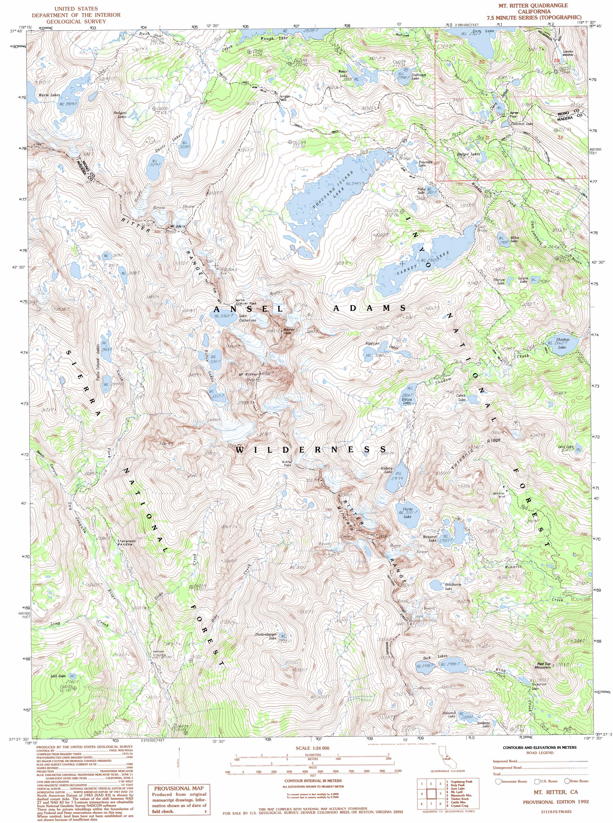
Mount Ritter Topo Map California
To zoom in, hover over the map of Mount Ritter
USGS Topo Quad 37119f2 - 1:24,000 scale
| Topo Map Name: | Mount Ritter |
| USGS Topo Quad ID: | 37119f2 |
| Print Size: | ca. 21 1/4" wide x 27" high |
| Southeast Coordinates: | 37.625° N latitude / 119.125° W longitude |
| Map Center Coordinates: | 37.6875° N latitude / 119.1875° W longitude |
| U.S. State: | CA |
| Filename: | o37119f2.jpg |
| Download Map JPG Image: | Mount Ritter topo map 1:24,000 scale |
| Map Type: | Topographic |
| Topo Series: | 7.5´ |
| Map Scale: | 1:24,000 |
| Source of Map Images: | United States Geological Survey (USGS) |
| Alternate Map Versions: |
Mt. Ritter CA 1983, updated 1984 Download PDF Buy paper map Mt. Ritter CA 1992, updated 1995 Download PDF Buy paper map Mt. Ritter CA 2004, updated 2007 Download PDF Buy paper map Mount Ritter CA 2012 Download PDF Buy paper map Mount Ritter CA 2015 Download PDF Buy paper map |
| FStopo: | US Forest Service topo Mount Ritter is available: Download FStopo PDF Download FStopo TIF |
1:24,000 Topo Quads surrounding Mount Ritter
Falls Ridge |
Tioga Pass |
Mount Dana |
Lee Vining |
Mono Mills |
Tenaya Lake |
Vogelsang Peak |
Koip Peak |
June Lake |
Crestview |
Merced Peak |
Mount Lyell |
Mount Ritter |
Mammoth Mountain |
Old Mammoth |
Sing Peak |
Timber Knob |
Cattle Mountain |
Crystal Crag |
Bloody Mountain |
Little Shuteye Peak |
Squaw Dome |
Balloon Dome |
Sharktooth Peak |
Graveyard Peak |
> Back to 37119e1 at 1:100,000 scale
> Back to 37118a1 at 1:250,000 scale
> Back to U.S. Topo Maps home
Mount Ritter topo map: Gazetteer
Mount Ritter: Crossings
Hemlock Crossing elevation 2307m 7568′Mount Ritter: Flats
Spooky Meadow elevation 2896m 9501′Stevenson Meadow elevation 2468m 8097′
Mount Ritter: Gaps
Agnew Pass elevation 3019m 9904′Island Pass elevation 3119m 10232′
Mount Ritter: Lakes
Altha Lake elevation 2961m 9714′Badger Lakes elevation 2927m 9603′
Beck Lakes elevation 2999m 9839′
Cabin Lake elevation 2916m 9566′
Cecile Lake elevation 3123m 10246′
Clarice Lake elevation 3019m 9904′
Clark Lakes elevation 3008m 9868′
Davis Lakes elevation 3036m 9960′
Deadhorse Lake elevation 3052m 10013′
Ediza Lake elevation 2826m 9271′
Emerald Lake elevation 3013m 9885′
Garnet Lake elevation 2952m 9685′
Holcomb Lake elevation 2891m 9484′
Iceberg Lake elevation 2981m 9780′
Lake Catherine elevation 3367m 11046′
Laura Lake elevation 2930m 9612′
Lost Lake elevation 2745m 9005′
Lost Lake elevation 3048m 10000′
Marie Lakes elevation 3316m 10879′
Minaret Lake elevation 2987m 9799′
Noname Lake elevation 2883m 9458′
Nydiver Lakes elevation 3082m 10111′
Rodgers Lakes elevation 3097m 10160′
Ruby Lake elevation 3023m 9917′
Shadow Lake elevation 2665m 8743′
Shellenbarger Lake elevation 2995m 9826′
Sullivan Lake elevation 2996m 9829′
Summit Lake elevation 2999m 9839′
Superior Lake elevation 2856m 9370′
Thousand Island Lake elevation 2999m 9839′
Twin Island Lakes elevation 2945m 9662′
Weber Lake elevation 3035m 9957′
Mount Ritter: Mines
Minaret Mine elevation 3091m 10141′Mount Ritter: Ranges
Ritter Range elevation 3665m 12024′Mount Ritter: Ridges
Volcanic Ridge elevation 3266m 10715′Mount Ritter: Streams
Dike Creek elevation 2257m 7404′Long Creek elevation 2351m 7713′
Slide Creek elevation 2326m 7631′
Mount Ritter: Summits
Banner Peak elevation 3921m 12864′Minarets elevation 3654m 11988′
Mount Davis elevation 3726m 12224′
Mount Ritter elevation 3943m 12936′
Red Top Mountain elevation 3207m 10521′
Mount Ritter: Valleys
Bench Canyon elevation 2526m 8287′Mount Ritter digital topo map on disk
Buy this Mount Ritter topo map showing relief, roads, GPS coordinates and other geographical features, as a high-resolution digital map file on DVD: