Yosemite Falls Topo Map California
To zoom in, hover over the map of Yosemite Falls
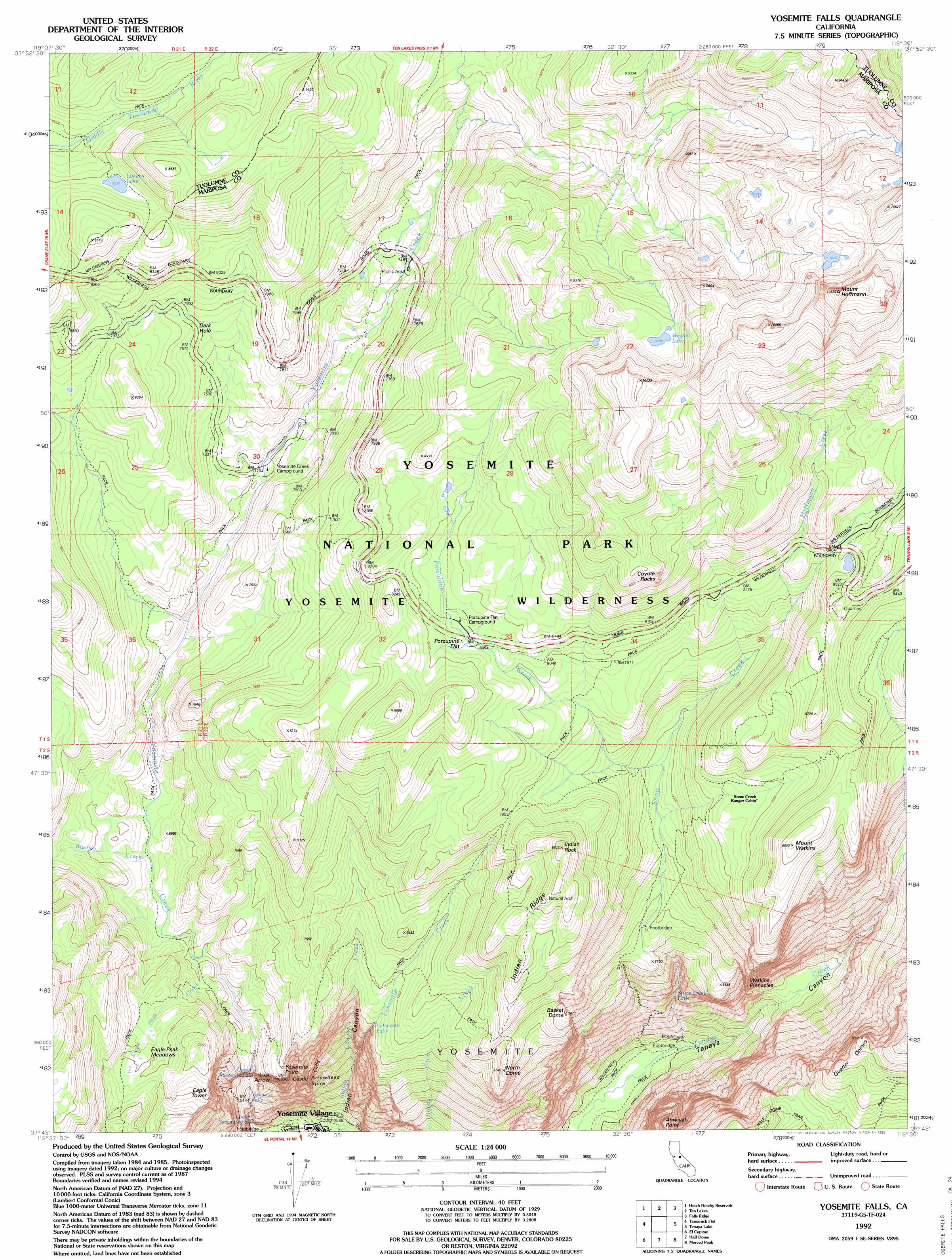
USGS Topo Quad 37119g5 - 1:24,000 scale
| Topo Map Name: | Yosemite Falls |
| USGS Topo Quad ID: | 37119g5 |
| Print Size: | ca. 21 1/4" wide x 27" high |
| Southeast Coordinates: | 37.75° N latitude / 119.5° W longitude |
| Map Center Coordinates: | 37.8125° N latitude / 119.5625° W longitude |
| U.S. State: | CA |
| Filename: | o37119g5.jpg |
| Download Map JPG Image: | Yosemite Falls topo map 1:24,000 scale |
| Map Type: | Topographic |
| Topo Series: | 7.5´ |
| Map Scale: | 1:24,000 |
| Source of Map Images: | United States Geological Survey (USGS) |
| Alternate Map Versions: |
Yosemite Falls CA 1990, updated 1990 Download PDF Buy paper map Yosemite Falls CA 1992, updated 1995 Download PDF Buy paper map Yosemite Falls CA 1997, updated 2002 Download PDF Buy paper map Yosemite Falls CA 2012 Download PDF Buy paper map Yosemite Falls CA 2015 Download PDF Buy paper map |
1:24,000 Topo Quads surrounding Yosemite Falls
Kibbie Lake |
Tiltill Mountain |
Piute Mountain |
Matterhorn Peak |
Dunderberg Peak |
Lake Eleanor |
Hetch Hetchy Reservoir |
Ten Lakes |
Falls Ridge |
Tioga Pass |
Ackerson Mountain |
Tamarack Flat |
Yosemite Falls |
Tenaya Lake |
Vogelsang Peak |
El Portal |
El Capitan |
Half Dome |
Merced Peak |
Mount Lyell |
Buckingham Mountain |
Wawona |
Mariposa Grove |
Sing Peak |
Timber Knob |
> Back to 37119e1 at 1:100,000 scale
> Back to 37118a1 at 1:250,000 scale
> Back to U.S. Topo Maps home
Yosemite Falls topo map: Gazetteer
Yosemite Falls: Basins
Dark Hole elevation 2380m 7808′Yosemite Falls: Cliffs
Castle Cliffs elevation 1814m 5951′Yosemite Point elevation 2115m 6938′
Yosemite Falls: Falls
Lehamite Falls elevation 2069m 6788′Lower Yosemite Fall elevation 1368m 4488′
Snow Creek Falls elevation 1594m 5229′
Upper Yosemite Falls elevation 1599m 5246′
Yosemite Falls elevation 2080m 6824′
Yosemite Falls: Flats
Eagle Peak Meadows elevation 2185m 7168′Porcupine Flat elevation 2471m 8106′
Snow Flat elevation 2651m 8697′
Yosemite Falls: Lakes
Lukens Lake elevation 2505m 8218′Wegner Lake elevation 2813m 9229′
Yosemite Falls: Parks
Yosemite National Park elevation 2434m 7985′Yosemite Falls: Pillars
Arrowhead Spire elevation 1944m 6377′Coyote Rocks elevation 2784m 9133′
Eagle Tower elevation 2216m 7270′
Lost Arrow elevation 2029m 6656′
Watkins Pinnacles elevation 1917m 6289′
Yosemite Falls: Ridges
Indian Ridge elevation 2465m 8087′Yosemite Falls: Streams
Bluejay Creek elevation 2085m 6840′Eagle Peak Creek elevation 2066m 6778′
Hoffmann Creek elevation 2387m 7831′
Lehamite Creek elevation 1525m 5003′
Porcupine Creek elevation 2170m 7119′
Snow Creek elevation 1274m 4179′
Yosemite Falls: Summits
Ahwiyah Point elevation 2103m 6899′Basket Dome elevation 2315m 7595′
Indian Rock elevation 2592m 8503′
Mount Hoffmann elevation 3283m 10770′
Mount Watkins elevation 2590m 8497′
North Dome elevation 2296m 7532′
Quarter Domes elevation 2522m 8274′
Yosemite Falls: Trails
Clouds Rest Trail elevation 2392m 7847′Eagle Peak Trail elevation 2082m 6830′
Half Dome Trail elevation 2308m 7572′
Hetch Hetchy Trail (historical) elevation 2094m 6870′
North Dome Trail (historical) elevation 2213m 7260′
Tenaya Lake and Tuolumne Meadows Trail (historical) elevation 2345m 7693′
Yosemite Falls Trail elevation 1532m 5026′
Yosemite Falls: Valleys
Indian Canyon elevation 1283m 4209′Yosemite Falls digital topo map on disk
Buy this Yosemite Falls topo map showing relief, roads, GPS coordinates and other geographical features, as a high-resolution digital map file on DVD: