Ascension Mountain Topo Map California
To zoom in, hover over the map of Ascension Mountain
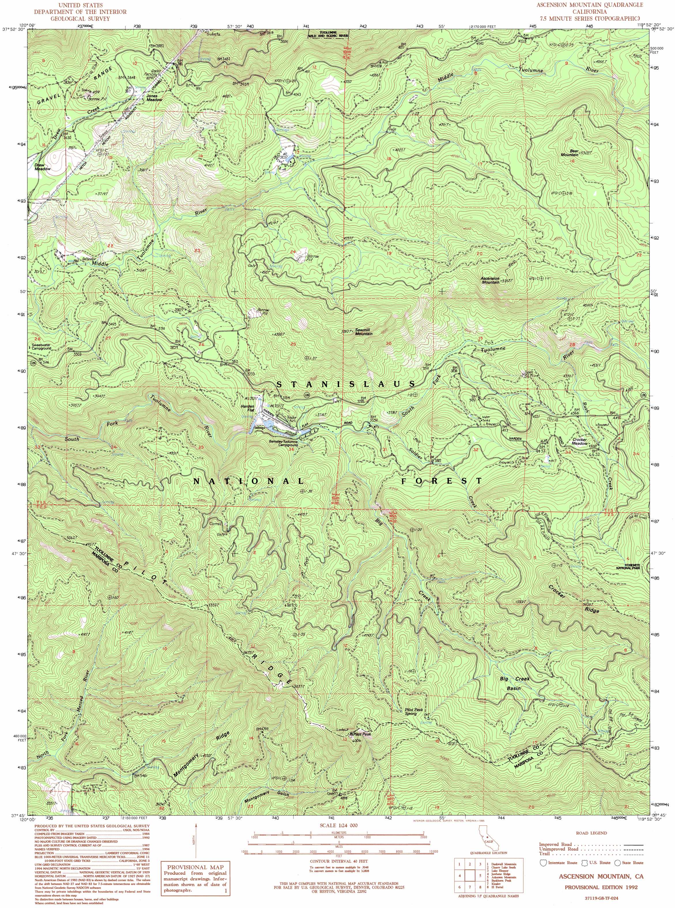
USGS Topo Quad 37119g8 - 1:24,000 scale
| Topo Map Name: | Ascension Mountain |
| USGS Topo Quad ID: | 37119g8 |
| Print Size: | ca. 21 1/4" wide x 27" high |
| Southeast Coordinates: | 37.75° N latitude / 119.875° W longitude |
| Map Center Coordinates: | 37.8125° N latitude / 119.9375° W longitude |
| U.S. State: | CA |
| Filename: | o37119g8.jpg |
| Download Map JPG Image: | Ascension Mountain topo map 1:24,000 scale |
| Map Type: | Topographic |
| Topo Series: | 7.5´ |
| Map Scale: | 1:24,000 |
| Source of Map Images: | United States Geological Survey (USGS) |
| Alternate Map Versions: |
Ascension Mountain CA 1990, updated 1990 Download PDF Buy paper map Ascension Mountain CA 1992, updated 1995 Download PDF Buy paper map Ascension Mountain CA 2001, updated 2004 Download PDF Buy paper map Ascension Mountain CA 2001, updated 2004 Download PDF Buy paper map Ascension Mountain CA 2012 Download PDF Buy paper map Ascension Mountain CA 2015 Download PDF Buy paper map |
| FStopo: | US Forest Service topo Ascension Mountain is available: Download FStopo PDF Download FStopo TIF |
1:24,000 Topo Quads surrounding Ascension Mountain
Twain Harte |
Hull Creek |
Cherry Lake North |
Kibbie Lake |
Tiltill Mountain |
Tuolumne |
Duckwall Mountain |
Cherry Lake South |
Lake Eleanor |
Hetch Hetchy Reservoir |
Groveland |
Jawbone Ridge |
Ascension Mountain |
Ackerson Mountain |
Tamarack Flat |
Coulterville |
Buckhorn Peak |
Kinsley |
El Portal |
El Capitan |
Hornitos |
Bear Valley |
Feliciana Mountain |
Buckingham Mountain |
Wawona |
> Back to 37119e1 at 1:100,000 scale
> Back to 37118a1 at 1:250,000 scale
> Back to U.S. Topo Maps home
Ascension Mountain topo map: Gazetteer
Ascension Mountain: Basins
Big Creek Basin elevation 1358m 4455′Ascension Mountain: Dams
Early Intake 9-000 Dam elevation 723m 2372′Ascension Mountain: Flats
Crocker Meadow elevation 1366m 4481′Jones Meadow elevation 1165m 3822′
Ascension Mountain: Mines
Five Star Mine (historical) elevation 1365m 4478′Ascension Mountain: Populated Places
Harden Flat elevation 1061m 3480′Sequoia elevation 1371m 4498′
Ascension Mountain: Ridges
Crocker Ridge elevation 1780m 5839′Montgomery Ridge elevation 1317m 4320′
Pilot Ridge elevation 1726m 5662′
Ascension Mountain: Springs
Pilot Peak Spring elevation 1582m 5190′Ascension Mountain: Streams
Ackerson Creek elevation 1302m 4271′Big Creek elevation 1072m 3517′
Rush Creek elevation 1191m 3907′
Soldier Creek elevation 1084m 3556′
Ascension Mountain: Summits
Ascension Mountain elevation 1600m 5249′Bear Mountain elevation 1610m 5282′
Pilot Peak elevation 1826m 5990′
Sawmill Mountain elevation 1600m 5249′
Ascension Mountain digital topo map on disk
Buy this Ascension Mountain topo map showing relief, roads, GPS coordinates and other geographical features, as a high-resolution digital map file on DVD: