Los Banos Topo Map California
To zoom in, hover over the map of Los Banos
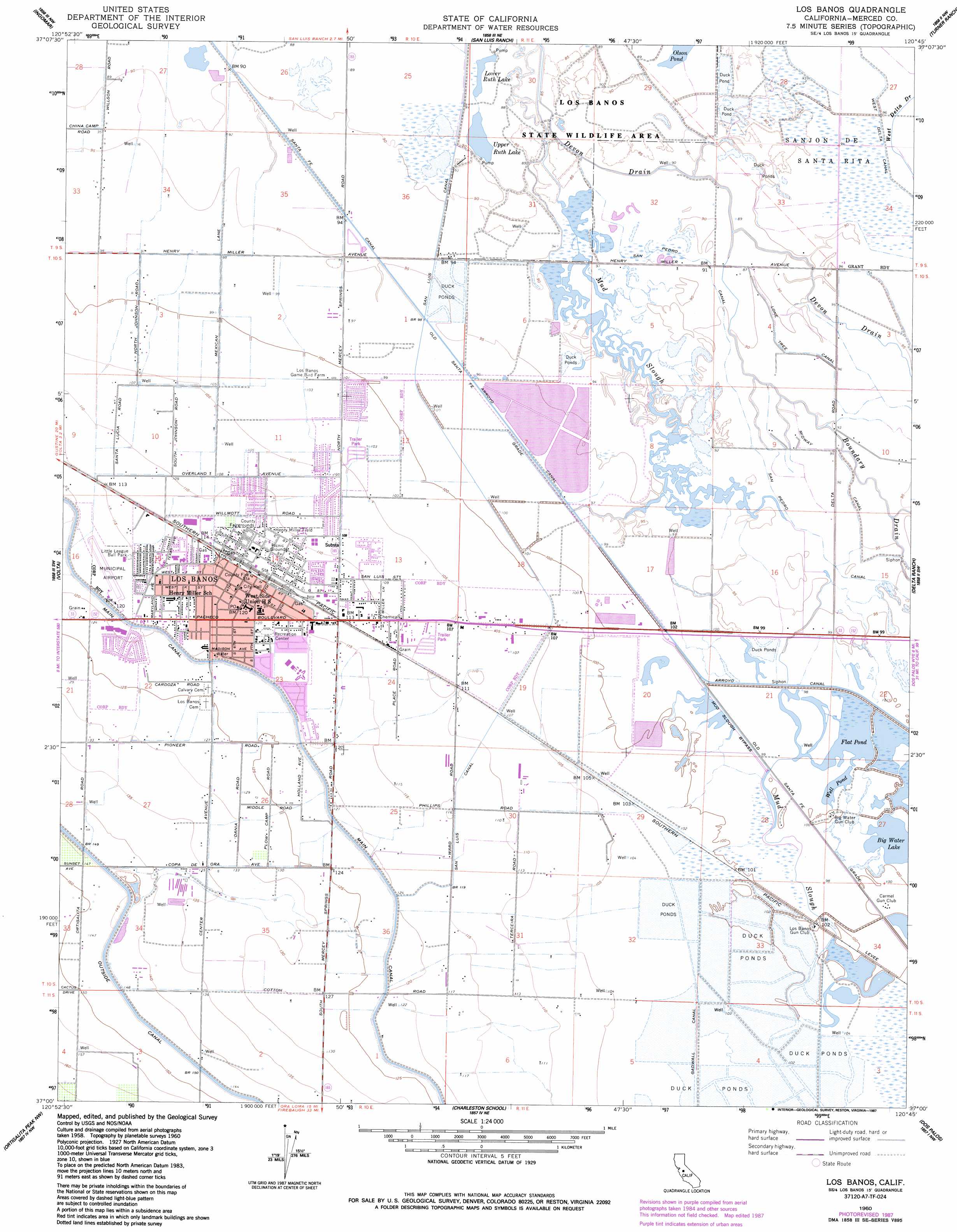
USGS Topo Quad 37120a7 - 1:24,000 scale
| Topo Map Name: | Los Banos |
| USGS Topo Quad ID: | 37120a7 |
| Print Size: | ca. 21 1/4" wide x 27" high |
| Southeast Coordinates: | 37° N latitude / 120.75° W longitude |
| Map Center Coordinates: | 37.0625° N latitude / 120.8125° W longitude |
| U.S. State: | CA |
| Filename: | o37120a7.jpg |
| Download Map JPG Image: | Los Banos topo map 1:24,000 scale |
| Map Type: | Topographic |
| Topo Series: | 7.5´ |
| Map Scale: | 1:24,000 |
| Source of Map Images: | United States Geological Survey (USGS) |
| Alternate Map Versions: |
Los Banos CA 1947 Download PDF Buy paper map Los Banos CA 1960, updated 1961 Download PDF Buy paper map Los Banos CA 1960, updated 1987 Download PDF Buy paper map Los Banos CA 1960, updated 1987 Download PDF Buy paper map Los Banos CA 2012 Download PDF Buy paper map Los Banos CA 2015 Download PDF Buy paper map |
1:24,000 Topo Quads surrounding Los Banos
Newman |
Gustine |
Stevinson |
Arena |
Atwater |
Howard Ranch |
Ingomar |
San Luis Ranch |
Turner Ranch |
Sandy Mush |
San Luis Dam |
Volta |
Los Banos |
Delta Ranch |
Santa Rita Bridge |
Los Banos Valley |
Ortigalita Peak Nw |
Charleston School |
Dos Palos |
Oxalis |
Ruby Canyon |
Ortigalita Peak |
Laguna Seca Ranch |
Hammonds Ranch |
Broadview Farms |
> Back to 37120a1 at 1:100,000 scale
> Back to 37120a1 at 1:250,000 scale
> Back to U.S. Topo Maps home
Los Banos topo map: Gazetteer
Los Banos: Airports
Los Banos Municipal Airport elevation 37m 121′Los Banos: Canals
Midway Canal elevation 29m 95′Mud Slough Bypass elevation 31m 101′
San Pedro Canal elevation 29m 95′
West Delta Canal elevation 30m 98′
Los Banos: Dams
Los Banos Sewage 2023 Dam elevation 30m 98′Los Banos: Flats
Henry Miller Field elevation 35m 114′Los Banos: Lakes
Big Water Lake elevation 31m 101′Flat Pond elevation 31m 101′
Lower Ruth Lake elevation 27m 88′
Olson Pond elevation 28m 91′
Upper Ruth Lake elevation 28m 91′
Well Pond elevation 31m 101′
Los Banos: Parks
Airport Park elevation 37m 121′Canal Farm State Historic Landmark elevation 34m 111′
Los Banos Fairgrounds Park elevation 35m 114′
Los Banos Regional Park elevation 30m 98′
Page Park elevation 36m 118′
Los Banos: Populated Places
Abbato (historical) elevation 36m 118′Gadwall (historical) elevation 31m 101′
Los Banos elevation 36m 118′
Los Banos: Post Offices
Los Banos Post Office elevation 36m 118′Los Banos: Streams
Boundary Drain elevation 27m 88′Boundary Drain Number One elevation 28m 91′
Devon Drain elevation 27m 88′
Los Banos digital topo map on disk
Buy this Los Banos topo map showing relief, roads, GPS coordinates and other geographical features, as a high-resolution digital map file on DVD: