Catheys Valley Topo Map California
To zoom in, hover over the map of Catheys Valley
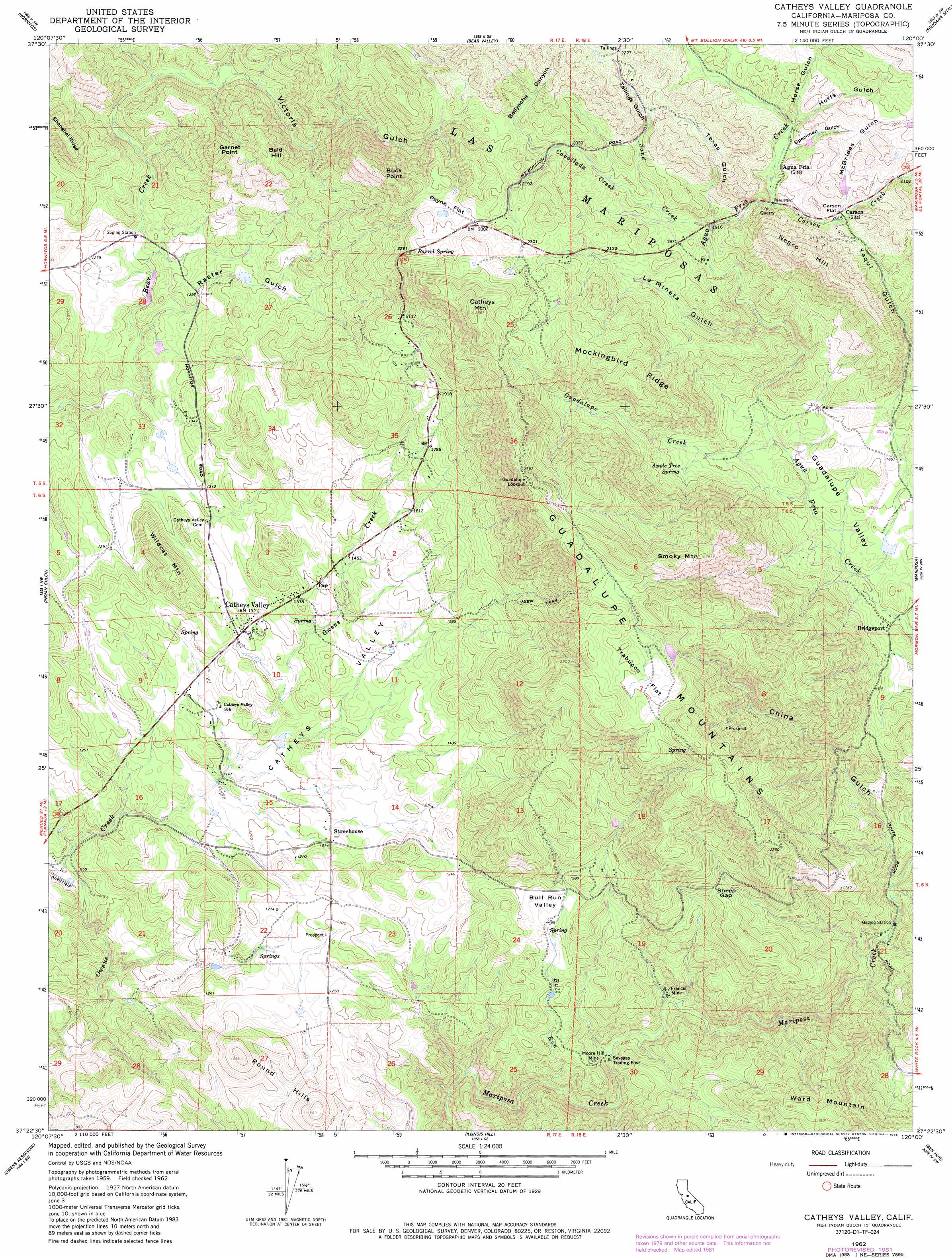
USGS Topo Quad 37120d1 - 1:24,000 scale
| Topo Map Name: | Catheys Valley |
| USGS Topo Quad ID: | 37120d1 |
| Print Size: | ca. 21 1/4" wide x 27" high |
| Southeast Coordinates: | 37.375° N latitude / 120° W longitude |
| Map Center Coordinates: | 37.4375° N latitude / 120.0625° W longitude |
| U.S. State: | CA |
| Filename: | o37120d1.jpg |
| Download Map JPG Image: | Catheys Valley topo map 1:24,000 scale |
| Map Type: | Topographic |
| Topo Series: | 7.5´ |
| Map Scale: | 1:24,000 |
| Source of Map Images: | United States Geological Survey (USGS) |
| Alternate Map Versions: |
Catheys Valley CA 1962, updated 1964 Download PDF Buy paper map Catheys Valley CA 1962, updated 1964 Download PDF Buy paper map Catheys Valley CA 1962, updated 1981 Download PDF Buy paper map Catheys Valley CA 1962, updated 1981 Download PDF Buy paper map Catheys Valley CA 1962, updated 1985 Download PDF Buy paper map Catheys Valley CA 2012 Download PDF Buy paper map Catheys Valley CA 2015 Download PDF Buy paper map |
1:24,000 Topo Quads surrounding Catheys Valley
Penon Blanco Peak |
Coulterville |
Buckhorn Peak |
Kinsley |
El Portal |
Merced Falls |
Hornitos |
Bear Valley |
Feliciana Mountain |
Buckingham Mountain |
Haystack Mountain |
Indian Gulch |
Catheys Valley |
Mariposa |
Stumpfield Mountain |
Planada |
Owens Reservoir |
Illinois Hill |
Ben Hur |
Horsecamp Mountain |
Plainsburg |
Le Grand |
Raynor Creek |
Raymond |
Knowles |
> Back to 37120a1 at 1:100,000 scale
> Back to 37120a1 at 1:250,000 scale
> Back to U.S. Topo Maps home
Catheys Valley topo map: Gazetteer
Catheys Valley: Basins
Guadalupe Valley elevation 482m 1581′Catheys Valley: Flats
Bull Run Valley elevation 439m 1440′Carson Flat elevation 621m 2037′
Payne Flat elevation 690m 2263′
Trabucco Flat elevation 758m 2486′
Catheys Valley: Gaps
Sheep Gap elevation 549m 1801′Catheys Valley: Mines
Francis Mine elevation 311m 1020′Moore Hill Mine elevation 342m 1122′
Catheys Valley: Parks
Catheys Valley Park elevation 430m 1410′Catheys Valley: Populated Places
Agua Fria elevation 610m 2001′Bridgeport elevation 457m 1499′
Catheys Valley elevation 404m 1325′
Catheys Valley: Ridges
Mockingbird Ridge elevation 785m 2575′Rattlesnake Ridge elevation 624m 2047′
Catheys Valley: Springs
Apple Tree Spring elevation 542m 1778′Barrel Spring elevation 688m 2257′
Catheys Valley: Streams
Bull Run elevation 249m 816′Carson Creek elevation 597m 1958′
Cavallada Creek elevation 592m 1942′
Guadalupe Creek elevation 489m 1604′
Sand Creek elevation 582m 1909′
Yaqui Creek elevation 457m 1499′
Catheys Valley: Summits
Bald Hill elevation 603m 1978′Buck Point elevation 758m 2486′
Catheys Mountain elevation 837m 2746′
Garnet Point elevation 608m 1994′
Guadalupe Mountains elevation 804m 2637′
Negro Hill elevation 785m 2575′
Round Hills elevation 478m 1568′
Smoky Mountain elevation 794m 2604′
Ward Mountain elevation 687m 2253′
Wildcat Mountain elevation 491m 1610′
Catheys Valley: Valleys
Bellyache Canyon elevation 663m 2175′Catheys Valley elevation 348m 1141′
China Gulch elevation 377m 1236′
Hoffs Gulch elevation 610m 2001′
Horse Gulch elevation 598m 1961′
La Mineta Gulch elevation 542m 1778′
McBrides Gulch elevation 612m 2007′
Raster Gulch elevation 354m 1161′
Specimen Gulch elevation 602m 1975′
Tailings Gulch elevation 635m 2083′
Texas Gulch elevation 575m 1886′
Victoria Gulch elevation 413m 1354′
Yaqui Gulch elevation 457m 1499′
Catheys Valley digital topo map on disk
Buy this Catheys Valley topo map showing relief, roads, GPS coordinates and other geographical features, as a high-resolution digital map file on DVD: