Coulterville Topo Map California
To zoom in, hover over the map of Coulterville
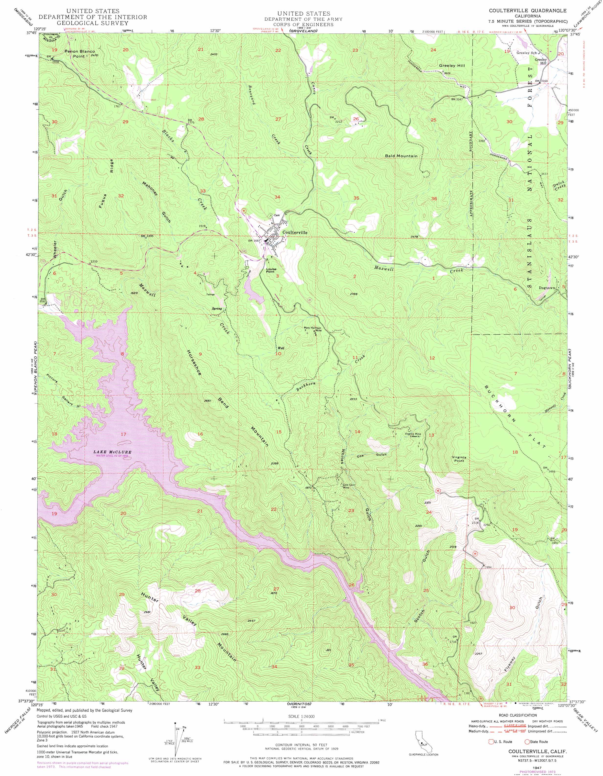
USGS Topo Quad 37120f2 - 1:24,000 scale
| Topo Map Name: | Coulterville |
| USGS Topo Quad ID: | 37120f2 |
| Print Size: | ca. 21 1/4" wide x 27" high |
| Southeast Coordinates: | 37.625° N latitude / 120.125° W longitude |
| Map Center Coordinates: | 37.6875° N latitude / 120.1875° W longitude |
| U.S. State: | CA |
| Filename: | o37120f2.jpg |
| Download Map JPG Image: | Coulterville topo map 1:24,000 scale |
| Map Type: | Topographic |
| Topo Series: | 7.5´ |
| Map Scale: | 1:24,000 |
| Source of Map Images: | United States Geological Survey (USGS) |
| Alternate Map Versions: |
Coulterville CA 1947, updated 1964 Download PDF Buy paper map Coulterville CA 1947, updated 1965 Download PDF Buy paper map Coulterville CA 1947, updated 1973 Download PDF Buy paper map Coulterville CA 1947, updated 1976 Download PDF Buy paper map Coulterville CA 1947, updated 1976 Download PDF Buy paper map Coulterville CA 1947, updated 1976 Download PDF Buy paper map Coulterville CA 1949, updated 1949 Download PDF Buy paper map Coulterville CA 2001, updated 2004 Download PDF Buy paper map Coulterville CA 2001, updated 2004 Download PDF Buy paper map Coulterville CA 2012 Download PDF Buy paper map Coulterville CA 2015 Download PDF Buy paper map |
| FStopo: | US Forest Service topo Coulterville is available: Download FStopo PDF Download FStopo TIF |
1:24,000 Topo Quads surrounding Coulterville
Sonora |
Standard |
Tuolumne |
Duckwall Mountain |
Cherry Lake South |
Chinese Camp |
Moccasin |
Groveland |
Jawbone Ridge |
Ascension Mountain |
La Grange |
Penon Blanco Peak |
Coulterville |
Buckhorn Peak |
Kinsley |
Snelling |
Merced Falls |
Hornitos |
Bear Valley |
Feliciana Mountain |
Yosemite Lake |
Haystack Mountain |
Indian Gulch |
Catheys Valley |
Mariposa |
> Back to 37120e1 at 1:100,000 scale
> Back to 37120a1 at 1:250,000 scale
> Back to U.S. Topo Maps home
Coulterville topo map: Gazetteer
Coulterville: Benches
Buckhorn Flat elevation 1031m 3382′Coulterville: Bends
Horseshoe Bend elevation 251m 823′Coulterville: Crossings
Split Rock Ferry (historical) elevation 251m 823′Coulterville: Dams
McMahon 674 Dam elevation 495m 1624′Coulterville: Flats
Tarantula Flat elevation 413m 1354′Coulterville: Mines
Adelaide Mine elevation 600m 1968′Black Spider Prospect elevation 715m 2345′
Champion Mine elevation 495m 1624′
Four Jacks Mine elevation 596m 1955′
Gold Coin Mine elevation 495m 1624′
Green Dragon Mine elevation 581m 1906′
Horseshoe Bend Mine elevation 437m 1433′
Malvina Mine elevation 529m 1735′
Mary Harrison Mine elevation 584m 1916′
Ming Prospect elevation 664m 2178′
Oriental Deposit elevation 593m 1945′
Oro Rico Mine elevation 715m 2345′
Red Ball Prospect elevation 738m 2421′
Red Banks Placer Mine elevation 251m 823′
Riverside Chrome Mine elevation 373m 1223′
Sonora Marble Agregates Quarry elevation 607m 1991′
Wheeler Gulch Mine elevation 415m 1361′
Yang Prospect elevation 685m 2247′
Coulterville: Parks
Coulterville Main Street Historic District elevation 515m 1689′Coulterville Park elevation 515m 1689′
Horseshoe Bend Recreation Area elevation 274m 898′
Hunters Valley Point Recreation Area elevation 278m 912′
Coulterville: Populated Places
Coulterville elevation 518m 1699′Dogtown elevation 787m 2582′
Newtown (historical) elevation 555m 1820′
Coulterville: Ridges
Fugua Ridge elevation 635m 2083′Coulterville: Streams
Blacks Creek elevation 329m 1079′Boneyard Creek elevation 582m 1909′
Buckhorn Creek elevation 473m 1551′
Cuneo Creek elevation 565m 1853′
Maxwell Creek elevation 785m 2575′
Willow Creek elevation 251m 823′
Coulterville: Summits
Bald Mountain elevation 967m 3172′Greeley Hill elevation 1101m 3612′
Horseshoe Bend Mountain elevation 800m 2624′
Hunter Valley Mountain elevation 814m 2670′
Louise Point elevation 570m 1870′
Peñon Blanco Point elevation 747m 2450′
Virginia Point elevation 978m 3208′
Coulterville: Valleys
Coe Gulch elevation 418m 1371′Log Cabin Gulch elevation 251m 823′
Mahoney Gulch elevation 457m 1499′
Picture Gallery Gulch elevation 251m 823′
Rancho del Oro Gulch elevation 252m 826′
Scotch Gulch elevation 251m 823′
Wheeler Gulch elevation 255m 836′
Whites Gulch elevation 251m 823′
Coulterville digital topo map on disk
Buy this Coulterville topo map showing relief, roads, GPS coordinates and other geographical features, as a high-resolution digital map file on DVD: