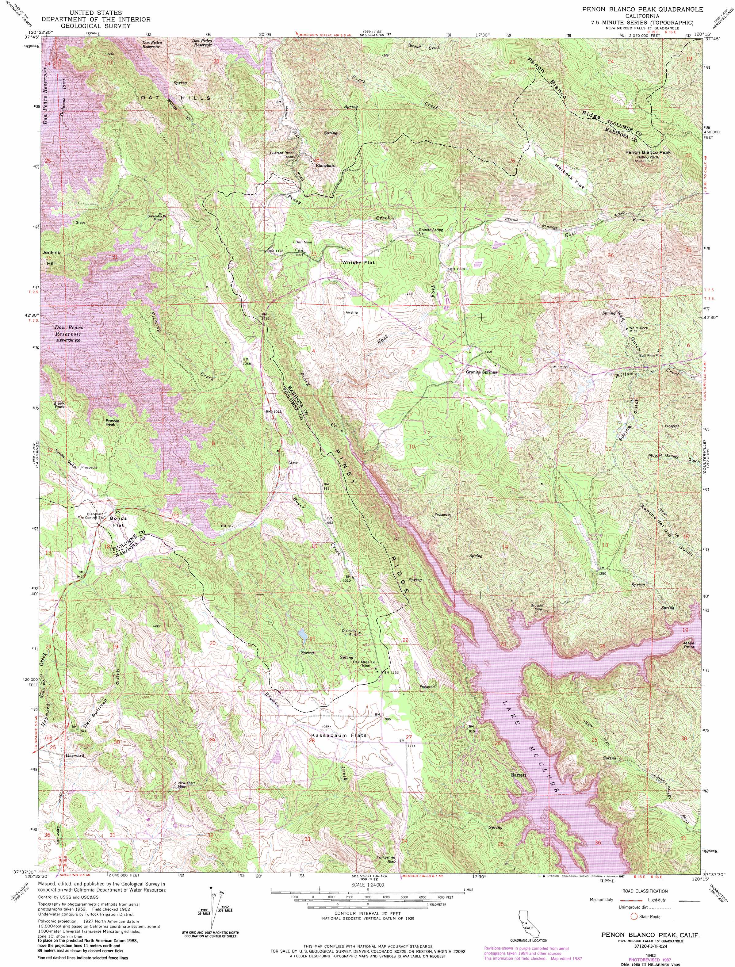
Penon Blanco Peak Topo Map California
To zoom in, hover over the map of Penon Blanco Peak
USGS Topo Quad 37120f3 - 1:24,000 scale
| Topo Map Name: | Penon Blanco Peak |
| USGS Topo Quad ID: | 37120f3 |
| Print Size: | ca. 21 1/4" wide x 27" high |
| Southeast Coordinates: | 37.625° N latitude / 120.25° W longitude |
| Map Center Coordinates: | 37.6875° N latitude / 120.3125° W longitude |
| U.S. State: | CA |
| Filename: | o37120f3.jpg |
| Download Map JPG Image: | Penon Blanco Peak topo map 1:24,000 scale |
| Map Type: | Topographic |
| Topo Series: | 7.5´ |
| Map Scale: | 1:24,000 |
| Source of Map Images: | United States Geological Survey (USGS) |
| Alternate Map Versions: |
Penon Blanco Peak CA 1962, updated 1963 Download PDF Buy paper map Penon Blanco Peak CA 1962, updated 1972 Download PDF Buy paper map Penon Blanco Peak CA 1962, updated 1976 Download PDF Buy paper map Penon Blanco Peak CA 1962, updated 1987 Download PDF Buy paper map Penon Blanco Peak CA 2012 Download PDF Buy paper map Penon Blanco Peak CA 2015 Download PDF Buy paper map |
1:24,000 Topo Quads surrounding Penon Blanco Peak
New Melones Dam |
Sonora |
Standard |
Tuolumne |
Duckwall Mountain |
Keystone |
Chinese Camp |
Moccasin |
Groveland |
Jawbone Ridge |
Cooperstown |
La Grange |
Penon Blanco Peak |
Coulterville |
Buckhorn Peak |
Turlock Lake |
Snelling |
Merced Falls |
Hornitos |
Bear Valley |
Winton |
Yosemite Lake |
Haystack Mountain |
Indian Gulch |
Catheys Valley |
> Back to 37120e1 at 1:100,000 scale
> Back to 37120a1 at 1:250,000 scale
> Back to U.S. Topo Maps home
Penon Blanco Peak topo map: Gazetteer
Penon Blanco Peak: Capes
Jasper Point elevation 312m 1023′Penon Blanco Peak: Dams
McSwain 58-004 Dam elevation 339m 1112′Penon Blanco Peak: Flats
Bonds Flat elevation 299m 980′Herbeck Flat elevation 570m 1870′
Kassabaum Flats elevation 330m 1082′
Whisky Flat elevation 431m 1414′
Penon Blanco Peak: Gaps
Fortynine Gap elevation 396m 1299′Penon Blanco Peak: Mines
Bruschi Mine elevation 284m 931′Bull Pine Mine elevation 313m 1026′
Burr Mine elevation 387m 1269′
Buzzard Roost Mine elevation 364m 1194′
Diamond Mine elevation 331m 1085′
Hedley Mine elevation 295m 967′
New Years Mine elevation 216m 708′
Oak Mesa Mine elevation 340m 1115′
Solambo Mine elevation 309m 1013′
White Rock Mine elevation 342m 1122′
Penon Blanco Peak: Parks
Barrett Cove Recreation Area elevation 307m 1007′Penon Blanco Peak: Populated Places
Barrett elevation 267m 875′Blanchard elevation 355m 1164′
Granite Springs elevation 432m 1417′
Hayward elevation 196m 643′
Penon Blanco Peak: Ranges
Oat Hills elevation 400m 1312′Penon Blanco Peak: Ridges
Piney Ridge elevation 460m 1509′Penon Blanco Peak: Streams
East Fork Piney Creek elevation 257m 843′Fleming Creek elevation 245m 803′
Graveyard Creek elevation 245m 803′
Hatch Creek elevation 244m 800′
Piney Creek elevation 254m 833′
Roger Creek elevation 245m 803′
Willow Creek elevation 245m 803′
Penon Blanco Peak: Summits
Blank Peak elevation 322m 1056′Penole Peak elevation 290m 951′
Peñon Blanco Peak elevation 872m 2860′
Penon Blanco Peak: Valleys
Dan Sullivan Gulch elevation 191m 626′Ned Gulch elevation 294m 964′
Spring Gulch elevation 302m 990′
Penon Blanco Peak digital topo map on disk
Buy this Penon Blanco Peak topo map showing relief, roads, GPS coordinates and other geographical features, as a high-resolution digital map file on DVD: