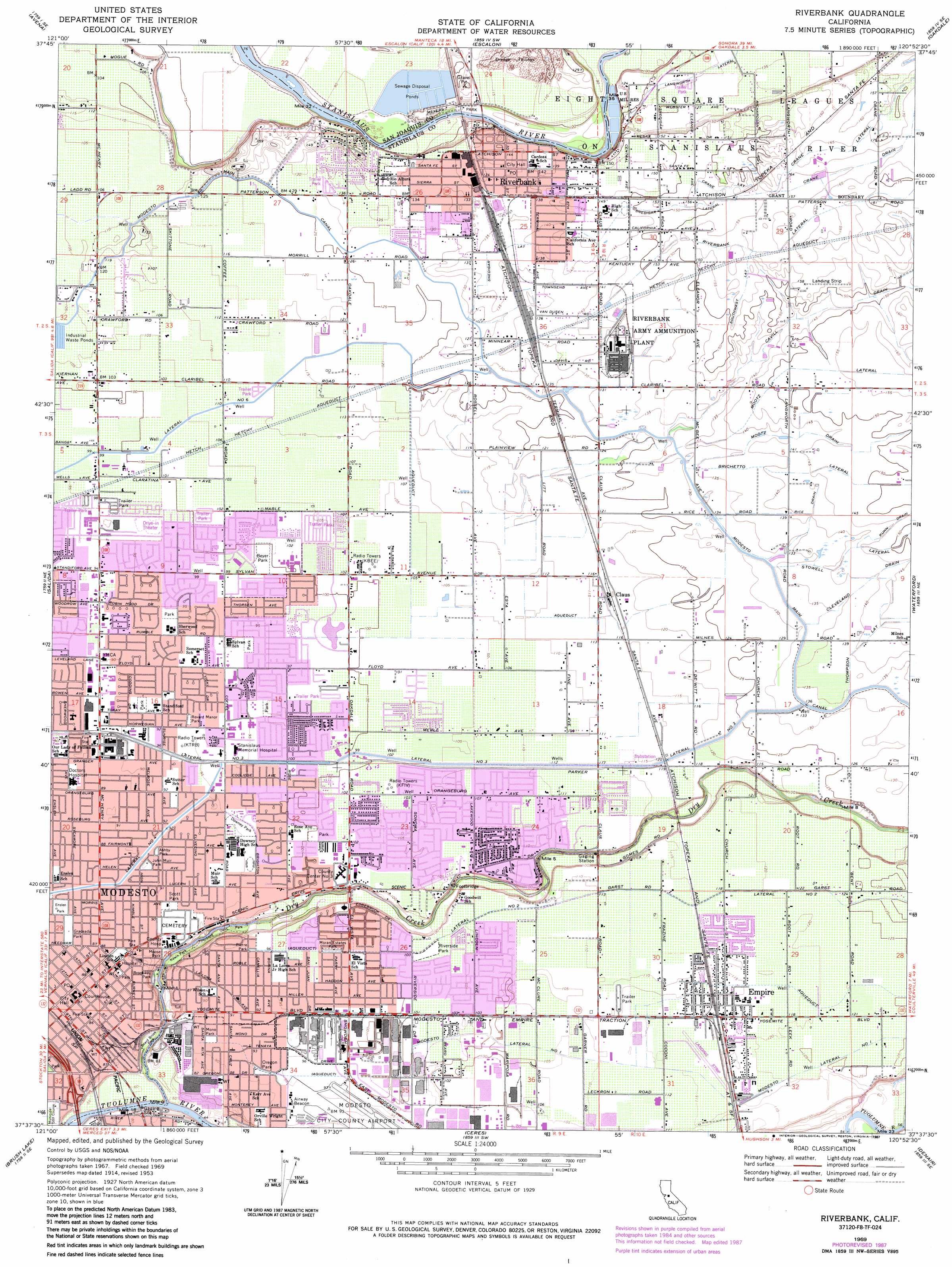
Riverbank Topo Map California
To zoom in, hover over the map of Riverbank
USGS Topo Quad 37120f8 - 1:24,000 scale
| Topo Map Name: | Riverbank |
| USGS Topo Quad ID: | 37120f8 |
| Print Size: | ca. 21 1/4" wide x 27" high |
| Southeast Coordinates: | 37.625° N latitude / 120.875° W longitude |
| Map Center Coordinates: | 37.6875° N latitude / 120.9375° W longitude |
| U.S. State: | CA |
| Filename: | o37120f8.jpg |
| Download Map JPG Image: | Riverbank topo map 1:24,000 scale |
| Map Type: | Topographic |
| Topo Series: | 7.5´ |
| Map Scale: | 1:24,000 |
| Source of Map Images: | United States Geological Survey (USGS) |
| Alternate Map Versions: |
Riverbank CA 1953, updated 1954 Download PDF Buy paper map Riverbank CA 1969, updated 1972 Download PDF Buy paper map Riverbank CA 1969, updated 1978 Download PDF Buy paper map Riverbank CA 1969, updated 1987 Download PDF Buy paper map Riverbank CA 2012 Download PDF Buy paper map Riverbank CA 2015 Download PDF Buy paper map |
1:24,000 Topo Quads surrounding Riverbank
Stockton East |
Peters |
Farmington |
Bachelor Valley |
Copperopolis |
Manteca |
Avena |
Escalon |
Oakdale |
Knights Ferry |
Ripon |
Salida |
Riverbank |
Waterford |
Paulsell |
Westley |
Brush Lake |
Ceres |
Denair |
Montpelier |
Patterson |
Crows Landing |
Hatch |
Turlock |
Cressey |
> Back to 37120e1 at 1:100,000 scale
> Back to 37120a1 at 1:250,000 scale
> Back to U.S. Topo Maps home
Riverbank topo map: Gazetteer
Riverbank: Airports
Hawke Airport elevation 48m 157′Modesto City-County Airport elevation 27m 88′
Riverbank: Bridges
Riverbank Bridge (historical) elevation 24m 78′Riverbank: Canals
Cavill Drain elevation 45m 147′Cleveland Drain elevation 44m 144′
Crane Drain elevation 50m 164′
Lateral Number Two elevation 37m 121′
Modesto Lateral Number One elevation 39m 127′
Mootz Drain elevation 46m 150′
Mootz Lateral elevation 49m 160′
Rice Drain elevation 43m 141′
Snedigar Lateral elevation 46m 150′
Southwest Lateral elevation 49m 160′
Thompson Lateral elevation 46m 150′
Riverbank: Crossings
Burneyville Ferry (historical) elevation 24m 78′Riverbank: Parks
Ashby Park elevation 28m 91′Beard Brook Park elevation 21m 68′
Beyer Park elevation 31m 101′
Brookway Park elevation 21m 68′
C F Brown Park elevation 30m 98′
California Avenue Park elevation 45m 147′
Coffee Park elevation 32m 104′
Downey Park elevation 30m 98′
Dry Creek Regional Park elevation 30m 98′
Enslen Park elevation 27m 88′
Floyd Number 2 Park elevation 30m 98′
Graceada Park elevation 27m 88′
Hutcheson Park elevation 40m 131′
John Muir Park elevation 28m 91′
Kewin Park elevation 22m 72′
Lakewood Park elevation 33m 108′
Meyers Park elevation 31m 101′
Mono Park elevation 28m 91′
Moose Park elevation 24m 78′
Moran Estates Park elevation 31m 101′
Orchard Park elevation 32m 104′
Oregon Park elevation 28m 91′
Pierre Park elevation 30m 98′
Revard Manor Park elevation 29m 95′
Riverside Park elevation 32m 104′
Sherwood Park elevation 30m 98′
Sipherd Park elevation 34m 111′
Standiford Park elevation 28m 91′
Sutter Park elevation 29m 95′
Sylvan Park elevation 30m 98′
Thousand Oaks Park elevation 20m 65′
Woodrow Park elevation 28m 91′
Riverbank: Populated Places
Claus elevation 36m 118′Empire elevation 36m 118′
Modesto elevation 27m 88′
Park Sierra Mobile Home Park elevation 41m 134′
Riverbank elevation 43m 141′
Riverside elevation 31m 101′
Riverbank: Post Offices
Empire Post Office elevation 36m 118′Riverbank Post Office elevation 43m 141′
Riverbank: Reservoirs
Naraghi Lake elevation 31m 101′Riverbank: Streams
Dry Creek elevation 14m 45′Riverbank digital topo map on disk
Buy this Riverbank topo map showing relief, roads, GPS coordinates and other geographical features, as a high-resolution digital map file on DVD: