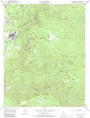
Tuolumne Topo Map California
To zoom in, hover over the map of Tuolumne
USGS Topo Quad 37120h2 - 1:24,000 scale
| Topo Map Name: | Tuolumne |
| USGS Topo Quad ID: | 37120h2 |
| Print Size: | ca. 21 1/4" wide x 27" high |
| Southeast Coordinates: | 37.875° N latitude / 120.125° W longitude |
| Map Center Coordinates: | 37.9375° N latitude / 120.1875° W longitude |
| U.S. State: | CA |
| Filename: | o37120h2.jpg |
| Download Map JPG Image: | Tuolumne topo map 1:24,000 scale |
| Map Type: | Topographic |
| Topo Series: | 7.5´ |
| Map Scale: | 1:24,000 |
| Source of Map Images: | United States Geological Survey (USGS) |
| Alternate Map Versions: |
Tuolumne CA 1948, updated 1964 Download PDF Buy paper map Tuolumne CA 1948, updated 1970 Download PDF Buy paper map Tuolumne CA 1948, updated 1979 Download PDF Buy paper map Tuolumne CA 1949, updated 1949 Download PDF Buy paper map Tuolumne CA 2001, updated 2004 Download PDF Buy paper map Tuolumne CA 2012 Download PDF Buy paper map Tuolumne CA 2015 Download PDF Buy paper map |
| FStopo: | US Forest Service topo Tuolumne is available: Download FStopo PDF Download FStopo TIF |
1:24,000 Topo Quads surrounding Tuolumne
> Back to 37120e1 at 1:100,000 scale
> Back to 37120a1 at 1:250,000 scale
> Back to U.S. Topo Maps home
Tuolumne topo map: Gazetteer
Tuolumne: Airports
Hermitage Airport elevation 804m 2637′Tuolumne: Dams
Tuolumne Log Pond 558 Dam elevation 781m 2562′Tuolumne: Flats
Corcoran Flat elevation 865m 2837′Wet Meadow elevation 1093m 3585′
Tuolumne: Gaps
Two Dog Pass elevation 1277m 4189′Tuolumne: Mines
Aqua Caliente Mine elevation 993m 3257′Columbus Mine elevation 871m 2857′
Hattie Ester Mine elevation 782m 2565′
Jigger Bill Brothers Mine elevation 772m 2532′
North Star Mine elevation 841m 2759′
Ophir Mine elevation 991m 3251′
Providence Mine elevation 548m 1797′
Spring Gulch Mine elevation 833m 2732′
Tuolumne: Parks
Tuolumne Memorial Park elevation 791m 2595′Tuolumne: Populated Places
Arastraville elevation 953m 3126′Buchanan elevation 953m 3126′
Cherokee elevation 863m 2831′
Tuolumne elevation 791m 2595′
Tuolumne City elevation 790m 2591′
Tuolumne: Post Offices
Tuolumne Post Office elevation 792m 2598′Tuolumne: Ridges
Paper Cabin Ridge elevation 930m 3051′Tuolumne: Springs
Alder Spring elevation 921m 3021′Tuolumne: Streams
Basin Creek elevation 753m 2470′Big Creek elevation 282m 925′
Big Humbug Creek elevation 282m 925′
Duckwall Creek elevation 542m 1778′
Dyer Creek elevation 669m 2194′
Grapevine Creek elevation 334m 1095′
Hunter Creek elevation 432m 1417′
Indian Creek elevation 333m 1092′
Tuolumne: Summits
Mount Eaton elevation 951m 3120′Murphy Peak elevation 1365m 4478′
Sugarloaf elevation 1180m 3871′
Wet Meadow Hill elevation 1206m 3956′
Tuolumne: Trails
Rogge Trail elevation 1133m 3717′Tuolumne: Valleys
Cedar Gulch elevation 488m 1601′Tuolumne digital topo map on disk
Buy this Tuolumne topo map showing relief, roads, GPS coordinates and other geographical features, as a high-resolution digital map file on DVD:


