New Melones Dam Topo Map California
To zoom in, hover over the map of New Melones Dam
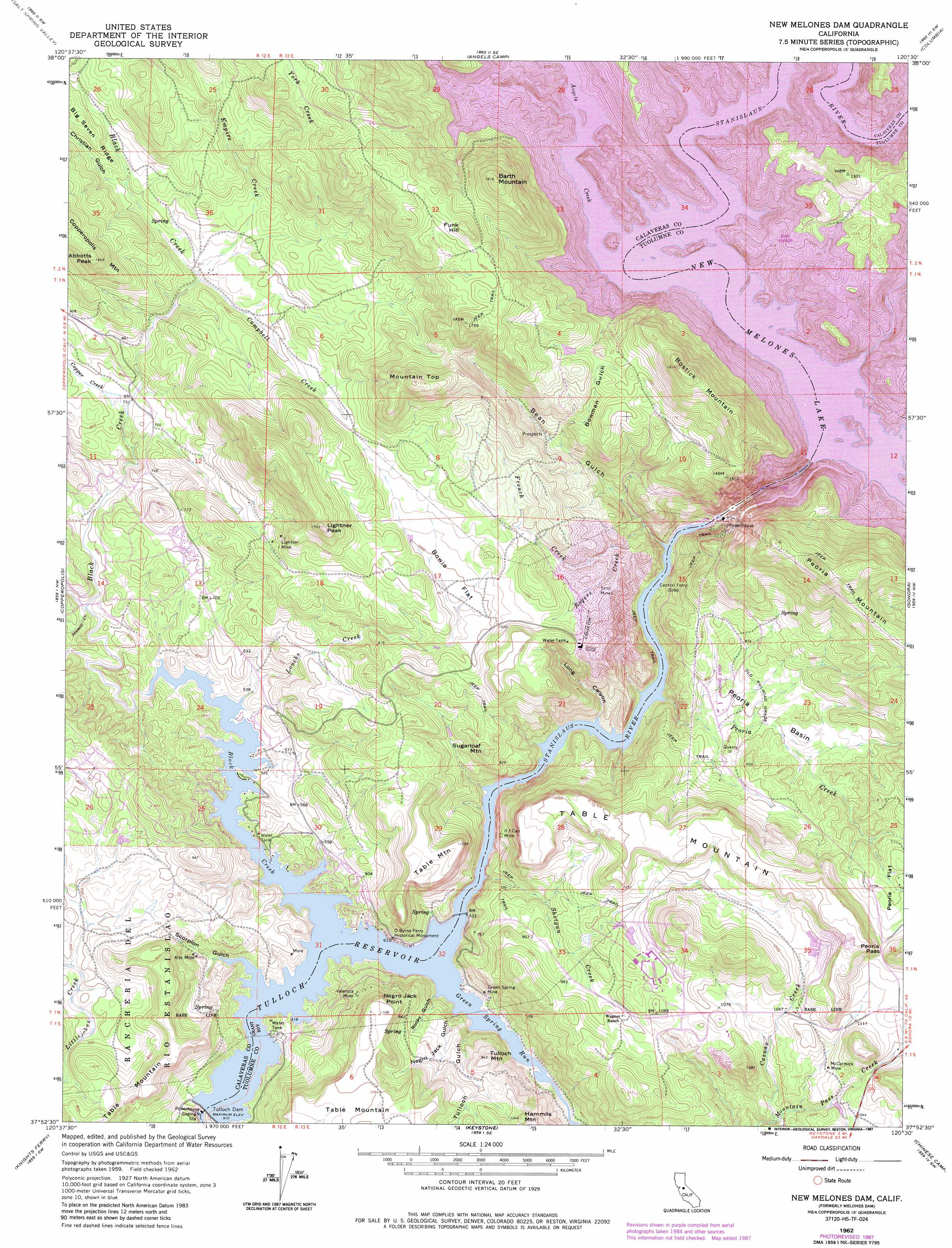
USGS Topo Quad 37120h5 - 1:24,000 scale
| Topo Map Name: | New Melones Dam |
| USGS Topo Quad ID: | 37120h5 |
| Print Size: | ca. 21 1/4" wide x 27" high |
| Southeast Coordinates: | 37.875° N latitude / 120.5° W longitude |
| Map Center Coordinates: | 37.9375° N latitude / 120.5625° W longitude |
| U.S. State: | CA |
| Filename: | o37120h5.jpg |
| Download Map JPG Image: | New Melones Dam topo map 1:24,000 scale |
| Map Type: | Topographic |
| Topo Series: | 7.5´ |
| Map Scale: | 1:24,000 |
| Source of Map Images: | United States Geological Survey (USGS) |
| Alternate Map Versions: |
Melones Dam CA 1962, updated 1963 Download PDF Buy paper map Melones Dam CA 1962, updated 1969 Download PDF Buy paper map New Melones Dam CA 1962, updated 1985 Download PDF Buy paper map New Melones Dam CA 1962, updated 1987 Download PDF Buy paper map New Melones Dam CA 2012 Download PDF Buy paper map New Melones Dam CA 2015 Download PDF Buy paper map |
1:24,000 Topo Quads surrounding New Melones Dam
Valley Springs |
San Andreas |
Calaveritas |
Murphys |
Stanislaus |
Jenny Lind |
Salt Spring Valley |
Angels Camp |
Columbia |
Columbia Se |
Bachelor Valley |
Copperopolis |
New Melones Dam |
Sonora |
Standard |
Oakdale |
Knights Ferry |
Keystone |
Chinese Camp |
Moccasin |
Waterford |
Paulsell |
Cooperstown |
La Grange |
Penon Blanco Peak |
> Back to 37120e1 at 1:100,000 scale
> Back to 37120a1 at 1:250,000 scale
> Back to U.S. Topo Maps home
New Melones Dam topo map: Gazetteer
New Melones Dam: Bars
Bostick Bar elevation 332m 1089′Vermont Bar elevation 332m 1089′
New Melones Dam: Basins
Peoria Basin elevation 249m 816′New Melones Dam: Cliffs
Negro Jack Point elevation 314m 1030′New Melones Dam: Crossings
O'Byrnes Ferry (historical) elevation 156m 511′Reynolds Ferry (historical) elevation 332m 1089′
New Melones Dam: Dams
Melones Dam (historical) elevation 332m 1089′New Melones Dam elevation 160m 524′
New Melones Dam elevation 166m 544′
Tulloch Dam elevation 134m 439′
New Melones Dam: Flats
Bowie Flat elevation 304m 997′New Melones Dam: Gaps
Peoria Pass elevation 365m 1197′New Melones Dam: Mines
Alto Mine elevation 186m 610′Green Spring Mine elevation 174m 570′
If I Can Mine elevation 214m 702′
Lightner Mine elevation 335m 1099′
McCormick Mine elevation 317m 1040′
Sugarloaf Mine elevation 326m 1069′
Valencia Mine elevation 255m 836′
New Melones Dam: Parks
O Byrne Ferry Historical Monument elevation 184m 603′South Shore Recreation Area elevation 164m 538′
New Melones Dam: Populated Places
Black Jack Bluffs elevation 219m 718′The Shores of Poker Flat elevation 178m 583′
New Melones Dam: Reservoirs
New Melones Lake elevation 160m 524′Tulloch Reservoir elevation 134m 439′
New Melones Dam: Streams
Andrew Creek elevation 306m 1003′Angels Creek elevation 332m 1089′
Black Creek elevation 332m 1089′
Black Creek elevation 156m 511′
Campbell Creek elevation 280m 918′
Casnau Creek elevation 249m 816′
Copper Creek elevation 226m 741′
Empire Creek elevation 281m 921′
French Creek elevation 186m 610′
Green Spring Run elevation 156m 511′
Loucks Creek elevation 156m 511′
Mormon Creek elevation 332m 1089′
Peoria Creek elevation 160m 524′
Rogers Creek elevation 243m 797′
Sawmill Creek elevation 171m 561′
Shotgun Creek elevation 158m 518′
York Creek elevation 327m 1072′
New Melones Dam: Summits
Abbotts Peak elevation 471m 1545′Barth Mountain elevation 581m 1906′
Bostick Mountain elevation 550m 1804′
Funk Hill elevation 529m 1735′
Hammils Mountain elevation 318m 1043′
Lightner Peak elevation 471m 1545′
Mountain Top elevation 520m 1706′
Peoria Mountain elevation 544m 1784′
Tulloch Mountain elevation 282m 925′
New Melones Dam: Valleys
Bean Gulch elevation 156m 511′Bowman Gulch elevation 282m 925′
Christian Gulch elevation 301m 987′
Iron Canyon elevation 156m 511′
Long Canyon elevation 156m 511′
Negro Jack Gulch elevation 158m 518′
Rocky Gulch elevation 172m 564′
Scorpion Gulch elevation 156m 511′
Texas Charley Gulch elevation 332m 1089′
Tulloch Gulch elevation 167m 547′
New Melones Dam digital topo map on disk
Buy this New Melones Dam topo map showing relief, roads, GPS coordinates and other geographical features, as a high-resolution digital map file on DVD: