Mustang Peak Topo Map California
To zoom in, hover over the map of Mustang Peak
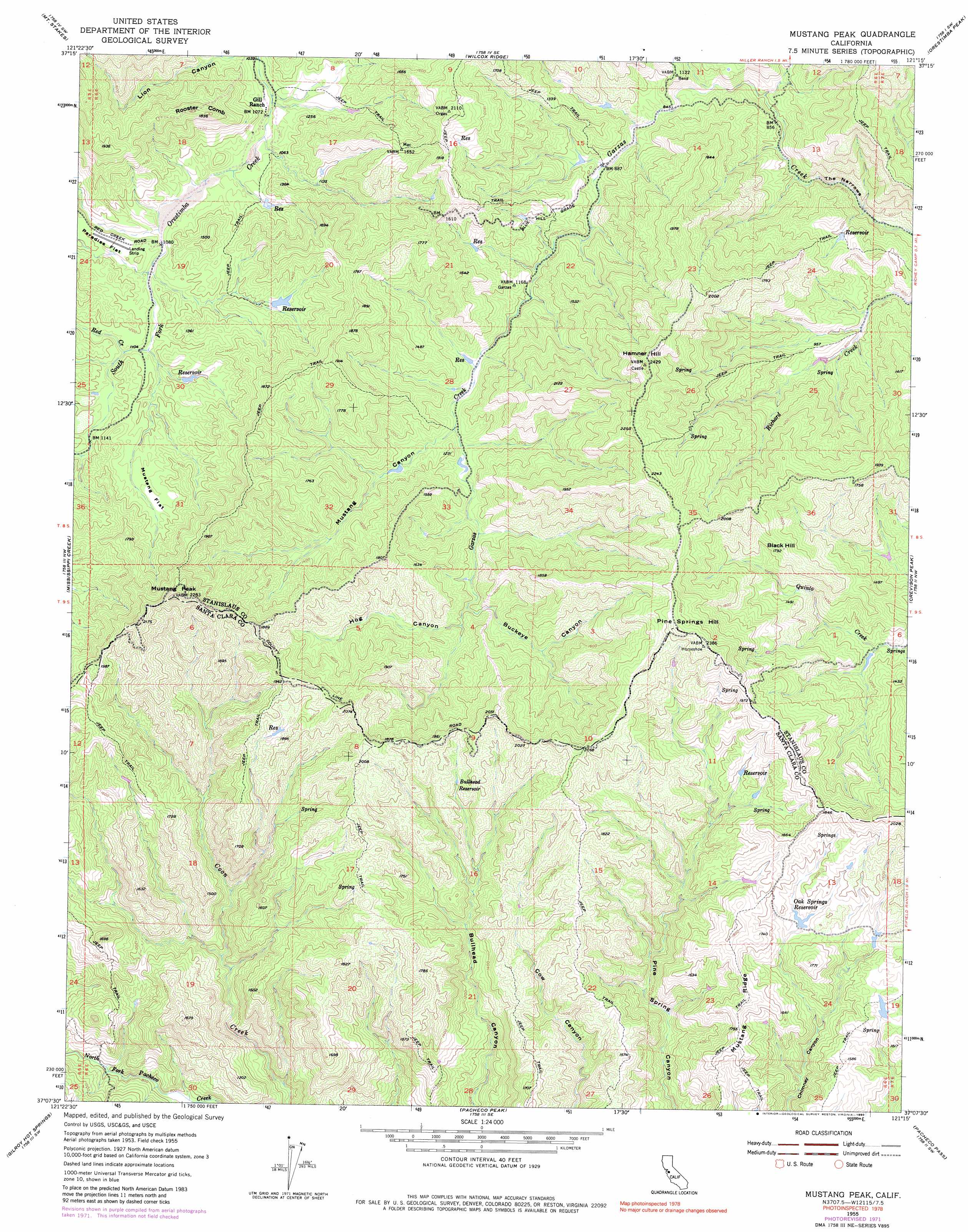
USGS Topo Quad 37121b3 - 1:24,000 scale
| Topo Map Name: | Mustang Peak |
| USGS Topo Quad ID: | 37121b3 |
| Print Size: | ca. 21 1/4" wide x 27" high |
| Southeast Coordinates: | 37.125° N latitude / 121.25° W longitude |
| Map Center Coordinates: | 37.1875° N latitude / 121.3125° W longitude |
| U.S. State: | CA |
| Filename: | o37121b3.jpg |
| Download Map JPG Image: | Mustang Peak topo map 1:24,000 scale |
| Map Type: | Topographic |
| Topo Series: | 7.5´ |
| Map Scale: | 1:24,000 |
| Source of Map Images: | United States Geological Survey (USGS) |
| Alternate Map Versions: |
Mustang Peak CA 1955, updated 1957 Download PDF Buy paper map Mustang Peak CA 1955, updated 1965 Download PDF Buy paper map Mustang Peak CA 1955, updated 1972 Download PDF Buy paper map Mustang Peak CA 1955, updated 1980 Download PDF Buy paper map Mustang Peak CA 1955, updated 1990 Download PDF Buy paper map Mustang Peak CA 2012 Download PDF Buy paper map Mustang Peak CA 2015 Download PDF Buy paper map |
1:24,000 Topo Quads surrounding Mustang Peak
Eylar Mountain |
Mount Boardman |
Copper Mountain |
Patterson |
Crows Landing |
Isabel Valley |
Mount Stakes |
Wilcox Ridge |
Orestimba Peak |
Newman |
Mount Sizer |
Mississippi Creek |
Mustang Peak |
Crevison Peak |
Howard Ranch |
Gilroy |
Gilroy Hot Springs |
Pacheco Peak |
Pacheco Pass |
San Luis Dam |
Chittenden |
San Felipe |
Three Sisters |
Mariposa Peak |
Los Banos Valley |
> Back to 37121a1 at 1:100,000 scale
> Back to 37120a1 at 1:250,000 scale
> Back to U.S. Topo Maps home
Mustang Peak topo map: Gazetteer
Mustang Peak: Capes
The Narrows elevation 217m 711′Mustang Peak: Flats
Mustang Flat elevation 405m 1328′Mustang Peak: Reservoirs
Bulhead Reservoir elevation 502m 1646′Oak Springs Reservoir elevation 454m 1489′
Mustang Peak: Ridges
Rooster Comb elevation 539m 1768′Mustang Peak: Streams
Red Creek elevation 340m 1115′Mustang Peak: Summits
Black Hill elevation 543m 1781′Hamner Hill elevation 717m 2352′
Mustang Peak elevation 682m 2237′
Pine Springs Hill elevation 721m 2365′
Mustang Peak: Valleys
Buckeye Canyon elevation 356m 1167′Hog Canyon elevation 368m 1207′
Mustang Canyon elevation 326m 1069′
Mustang Peak digital topo map on disk
Buy this Mustang Peak topo map showing relief, roads, GPS coordinates and other geographical features, as a high-resolution digital map file on DVD: