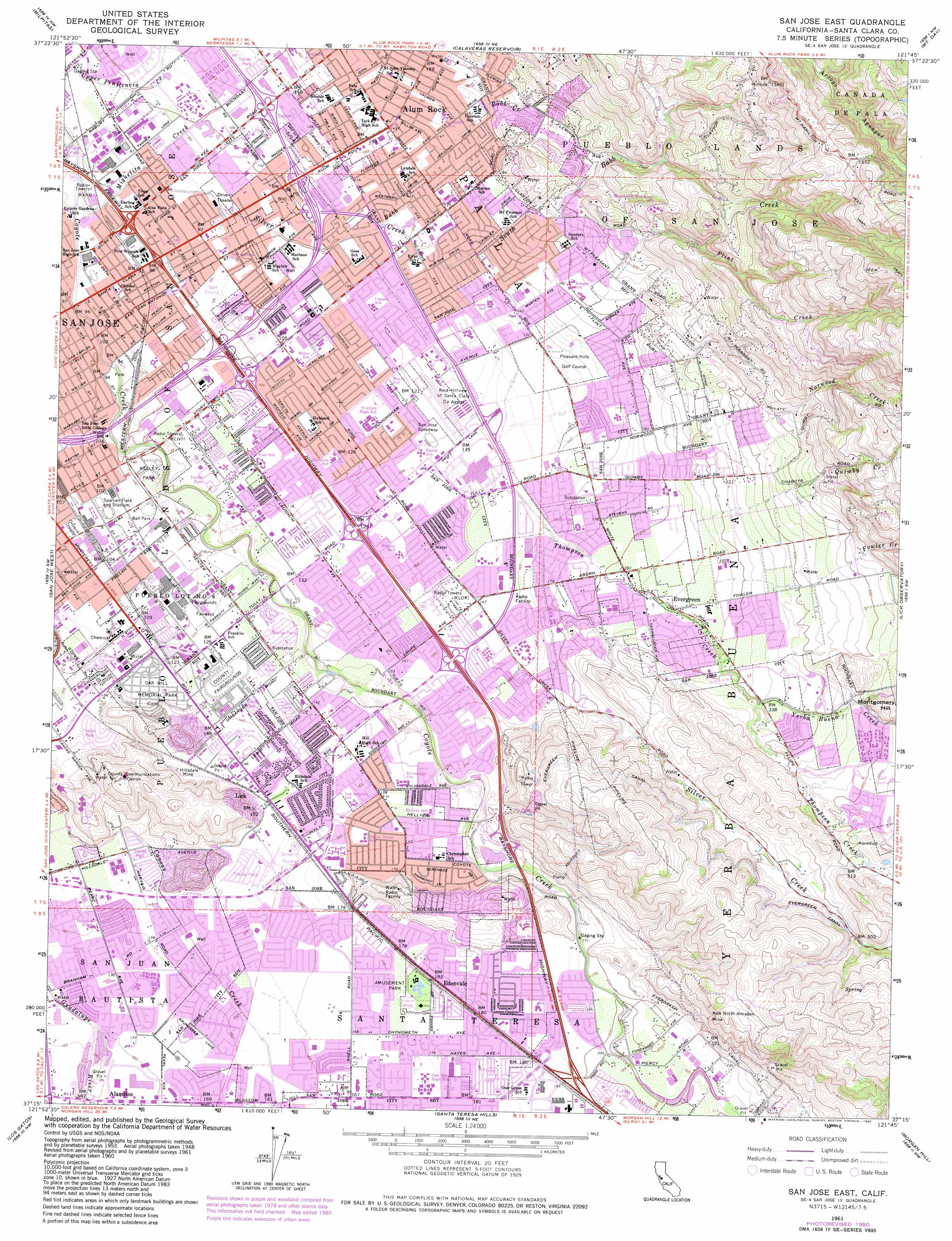
San Jose East Topo Map California
To zoom in, hover over the map of San Jose East
USGS Topo Quad 37121c7 - 1:24,000 scale
| Topo Map Name: | San Jose East |
| USGS Topo Quad ID: | 37121c7 |
| Print Size: | ca. 21 1/4" wide x 27" high |
| Southeast Coordinates: | 37.25° N latitude / 121.75° W longitude |
| Map Center Coordinates: | 37.3125° N latitude / 121.8125° W longitude |
| U.S. State: | CA |
| Filename: | o37121c7.jpg |
| Download Map JPG Image: | San Jose East topo map 1:24,000 scale |
| Map Type: | Topographic |
| Topo Series: | 7.5´ |
| Map Scale: | 1:24,000 |
| Source of Map Images: | United States Geological Survey (USGS) |
| Alternate Map Versions: |
San Jose East CA 1953, updated 1955 Download PDF Buy paper map San Jose East CA 1961, updated 1962 Download PDF Buy paper map San Jose East CA 1961, updated 1967 Download PDF Buy paper map San Jose East CA 1961, updated 1969 Download PDF Buy paper map San Jose East CA 1961, updated 1975 Download PDF Buy paper map San Jose East CA 1961, updated 1980 Download PDF Buy paper map San Jose East CA 2012 Download PDF Buy paper map San Jose East CA 2015 Download PDF Buy paper map |
1:24,000 Topo Quads surrounding San Jose East
Newark |
Niles |
La Costa Valley |
Mendenhall Springs |
Cedar Mountain |
Mountain View |
Milpitas |
Calaveras Reservoir |
Mount Day |
Eylar Mountain |
Cupertino |
San Jose West |
San Jose East |
Lick Observatory |
Isabel Valley |
Castle Rock Ridge |
Los Gatos |
Santa Teresa Hills |
Morgan Hill |
Mount Sizer |
Felton |
Laurel |
Loma Prieta |
Mount Madonna |
Gilroy |
> Back to 37121a1 at 1:100,000 scale
> Back to 37120a1 at 1:250,000 scale
> Back to U.S. Topo Maps home
San Jose East topo map: Gazetteer
San Jose East: Airports
Reid-Hillview of Santa Clara County Airport elevation 38m 124′San Jose East: Canals
Evergreen Canal elevation 159m 521′San Jose East: Crossings
Exit 1A elevation 32m 104′Exit 1B elevation 32m 104′
Exit 1C elevation 32m 104′
Exit 1D elevation 32m 104′
Exit 2 elevation 31m 101′
Exit 2A elevation 32m 104′
Exit 2B elevation 38m 124′
Exit 378 elevation 61m 200′
Exit 380 elevation 57m 187′
Exit 381 elevation 56m 183′
Exit 382 elevation 47m 154′
Exit 383 elevation 40m 131′
Exit 385 elevation 33m 108′
Exit 386A elevation 26m 85′
Exit 386B elevation 31m 101′
San Jose East: Dams
Columbine 622-015 Dam elevation 101m 331′San Jose East: Flats
Spartan Field elevation 33m 108′San Jose East: Mines
Hillsdale Mine elevation 48m 157′New North Almaden Mine elevation 131m 429′
San Jose East: Parks
Kelley Park elevation 36m 118′Phil Stennes Stadium elevation 54m 177′
San Jose Municipal Baseball Stadium elevation 34m 111′
Spartan Stadium elevation 33m 108′
San Jose East: Populated Places
Alamitos elevation 57m 187′Alum Rock elevation 46m 150′
Edenvale elevation 56m 183′
Evergreen elevation 75m 246′
Lick elevation 47m 154′
Seven Trees elevation 48m 157′
San Jose East: Streams
Babb Creek elevation 35m 114′Flint Creek elevation 42m 137′
Fowler Creek elevation 80m 262′
Miguelita Creek elevation 19m 62′
Norwood Creek elevation 72m 236′
Quimby Creek elevation 78m 255′
Silver Creek elevation 25m 82′
South Babb Creek elevation 40m 131′
Thompson Creek elevation 41m 134′
Yerba Buena Creek elevation 96m 314′
San Jose East: Summits
Montgomery Hill elevation 181m 593′San Jose East digital topo map on disk
Buy this San Jose East topo map showing relief, roads, GPS coordinates and other geographical features, as a high-resolution digital map file on DVD: