Mendenhall Springs Topo Map California
To zoom in, hover over the map of Mendenhall Springs
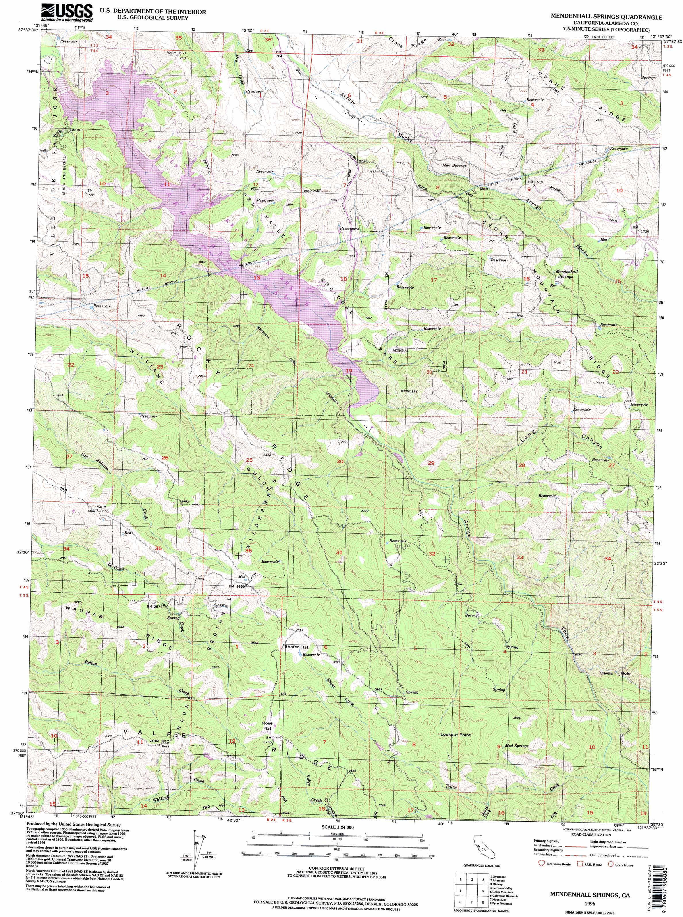
USGS Topo Quad 37121e6 - 1:24,000 scale
| Topo Map Name: | Mendenhall Springs |
| USGS Topo Quad ID: | 37121e6 |
| Print Size: | ca. 21 1/4" wide x 27" high |
| Southeast Coordinates: | 37.5° N latitude / 121.625° W longitude |
| Map Center Coordinates: | 37.5625° N latitude / 121.6875° W longitude |
| U.S. State: | CA |
| Filename: | o37121e6.jpg |
| Download Map JPG Image: | Mendenhall Springs topo map 1:24,000 scale |
| Map Type: | Topographic |
| Topo Series: | 7.5´ |
| Map Scale: | 1:24,000 |
| Source of Map Images: | United States Geological Survey (USGS) |
| Alternate Map Versions: |
Mendenhall Springs CA 1956, updated 1957 Download PDF Buy paper map Mendenhall Springs CA 1956, updated 1964 Download PDF Buy paper map Mendenhall Springs CA 1956, updated 1973 Download PDF Buy paper map Mendenhall Springs CA 1956, updated 1985 Download PDF Buy paper map Mendenhall Springs CA 1956, updated 1994 Download PDF Buy paper map Mendenhall Springs CA 1996, updated 1998 Download PDF Buy paper map Mendenhall Springs CA 2012 Download PDF Buy paper map Mendenhall Springs CA 2015 Download PDF Buy paper map |
1:24,000 Topo Quads surrounding Mendenhall Springs
Diablo |
Tassajara |
Byron Hot Springs |
Clifton Court Forebay |
Union Island |
Dublin |
Livermore |
Altamont |
Midway |
Tracy |
Niles |
La Costa Valley |
Mendenhall Springs |
Cedar Mountain |
Lone Tree Creek |
Milpitas |
Calaveras Reservoir |
Mount Day |
Eylar Mountain |
Mount Boardman |
San Jose West |
San Jose East |
Lick Observatory |
Isabel Valley |
Mount Stakes |
> Back to 37121e1 at 1:100,000 scale
> Back to 37120a1 at 1:250,000 scale
> Back to U.S. Topo Maps home
Mendenhall Springs topo map: Gazetteer
Mendenhall Springs: Bays
Heron Bay elevation 228m 748′Mendenhall Springs: Bends
Devils Hole elevation 351m 1151′Mendenhall Springs: Dams
Del Valle 1-056 Dam elevation 185m 606′Mendenhall Springs: Flats
Rose Flat elevation 1143m 3750′Shafer Flat elevation 1048m 3438′
Mendenhall Springs: Parks
Lake Del Valle State Recreation Area elevation 269m 882′Mendenhall Springs: Populated Places
Mendenhall Springs elevation 554m 1817′Mendenhall Springs: Reservoirs
Lake del Valle elevation 185m 606′Mendenhall Springs: Ridges
Cedar Mountain Ridge elevation 1025m 3362′Crane Ridge elevation 551m 1807′
Rocky Ridge elevation 628m 2060′
Mendenhall Springs: Springs
Mendenhall Springs elevation 535m 1755′Mud Springs elevation 436m 1430′
Mud Springs elevation 853m 2798′
Mendenhall Springs: Streams
Shafer Creek elevation 925m 3034′South Fork Trout Creek elevation 683m 2240′
Trout Creek elevation 326m 1069′
Mendenhall Springs: Summits
Lookout Point elevation 1051m 3448′Mendenhall Springs: Valleys
Lang Canyon elevation 243m 797′Mendenhall Springs digital topo map on disk
Buy this Mendenhall Springs topo map showing relief, roads, GPS coordinates and other geographical features, as a high-resolution digital map file on DVD: