Clifton Court Forebay Topo Map California
To zoom in, hover over the map of Clifton Court Forebay
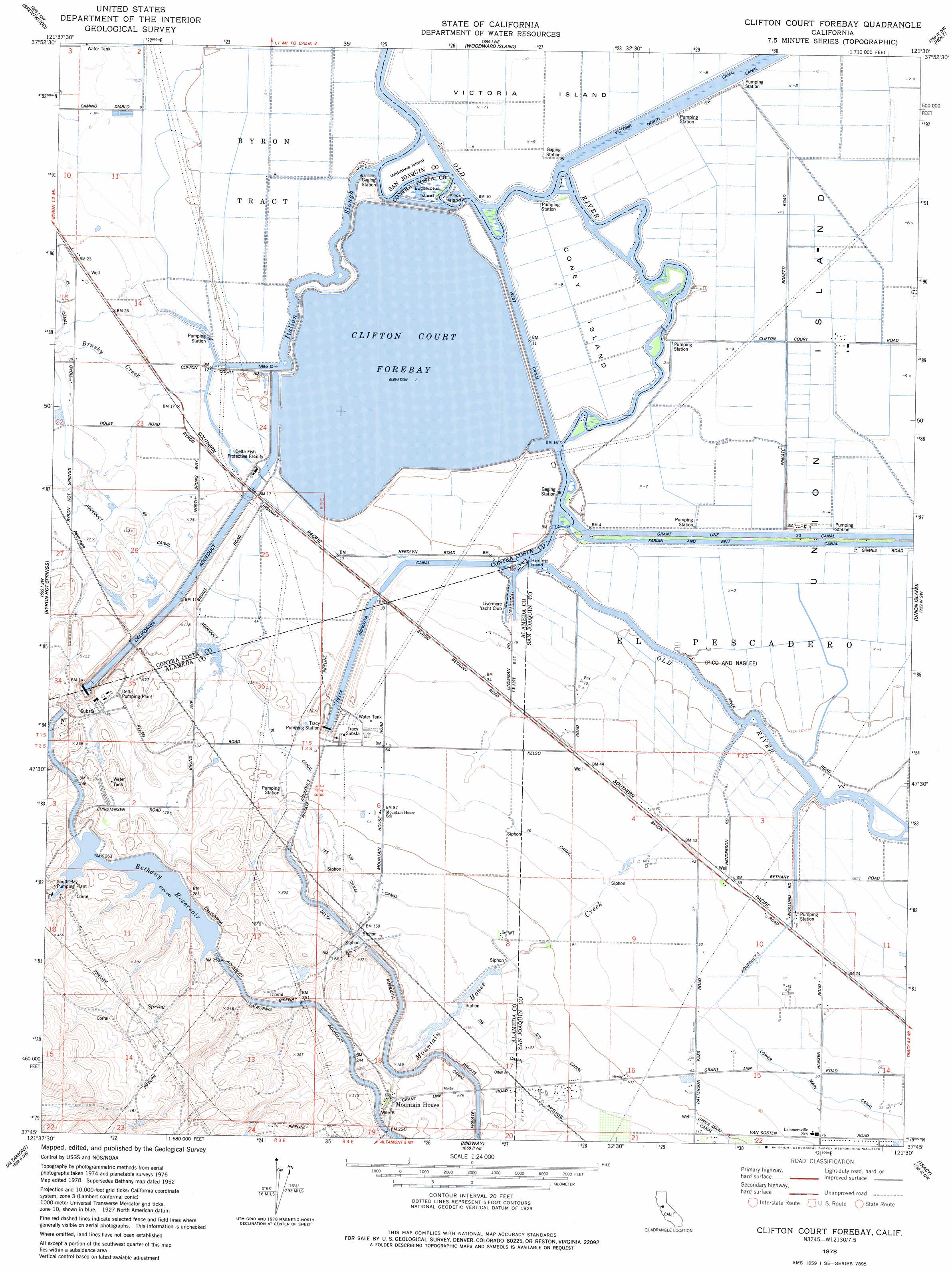
USGS Topo Quad 37121g5 - 1:24,000 scale
| Topo Map Name: | Clifton Court Forebay |
| USGS Topo Quad ID: | 37121g5 |
| Print Size: | ca. 21 1/4" wide x 27" high |
| Southeast Coordinates: | 37.75° N latitude / 121.5° W longitude |
| Map Center Coordinates: | 37.8125° N latitude / 121.5625° W longitude |
| U.S. State: | CA |
| Filename: | o37121g5.jpg |
| Download Map JPG Image: | Clifton Court Forebay topo map 1:24,000 scale |
| Map Type: | Topographic |
| Topo Series: | 7.5´ |
| Map Scale: | 1:24,000 |
| Source of Map Images: | United States Geological Survey (USGS) |
| Alternate Map Versions: |
Bethany CA 1952, updated 1955 Download PDF Buy paper map Bethany CA 1952, updated 1959 Download PDF Buy paper map Bethany CA 1952, updated 1966 Download PDF Buy paper map Bethany CA 1952, updated 1969 Download PDF Buy paper map Bethany CA 1952, updated 1969 Download PDF Buy paper map Bethany CA 1952, updated 1977 Download PDF Buy paper map Clifton Court Forebay CA 1978, updated 1978 Download PDF Buy paper map Clifton Court Forebay CA 1978, updated 1978 Download PDF Buy paper map Clifton Court Forebay CA 2012 Download PDF Buy paper map Clifton Court Forebay CA 2015 Download PDF Buy paper map |
1:24,000 Topo Quads surrounding Clifton Court Forebay
Antioch North |
Jersey Island |
Bouldin Island |
Terminous |
Lodi South |
Antioch South |
Brentwood |
Woodward Island |
Holt |
Stockton West |
Tassajara |
Byron Hot Springs |
Clifton Court Forebay |
Union Island |
Lathrop |
Livermore |
Altamont |
Midway |
Tracy |
Vernalis |
La Costa Valley |
Mendenhall Springs |
Cedar Mountain |
Lone Tree Creek |
Solyo |
> Back to 37121e1 at 1:100,000 scale
> Back to 37120a1 at 1:250,000 scale
> Back to U.S. Topo Maps home
Clifton Court Forebay topo map: Gazetteer
Clifton Court Forebay: Canals
One Hundred and Fifty-five Canal elevation 48m 157′One Hundred and Twenty Canal elevation 35m 114′
West Canal elevation 0m 0′
Clifton Court Forebay: Crossings
Bethany Ferry (historical) elevation 1m 3′Clifton Court Forebay: Dams
Bethany Forebay 1-045 Dam elevation 74m 242′Califton Court Forebay 1-064 Dam elevation 1m 3′
Clifton Court Forebay: Guts
Italian Slough elevation 0m 0′Clifton Court Forebay: Islands
Coney Island elevation -1m -4′Eucalyptus Island elevation 1m 3′
Hammer Island elevation 1m 3′
Kings Island elevation -1m -4′
Widdows Island elevation 0m 0′
Clifton Court Forebay: Parks
Bethany Reservoir State Recreation Area elevation 76m 249′Clifton Court Forebay: Populated Places
Mountain House elevation 18m 59′Clifton Court Forebay: Reservoirs
Bethany Reservoir elevation 74m 242′Clifton Court Forebay elevation 1m 3′
Clifton Court Forebay: Streams
Brushy Creek elevation 1m 3′Mountain House Creek elevation 2m 6′
Clifton Court Forebay digital topo map on disk
Buy this Clifton Court Forebay topo map showing relief, roads, GPS coordinates and other geographical features, as a high-resolution digital map file on DVD: