Felton Topo Map California
To zoom in, hover over the map of Felton
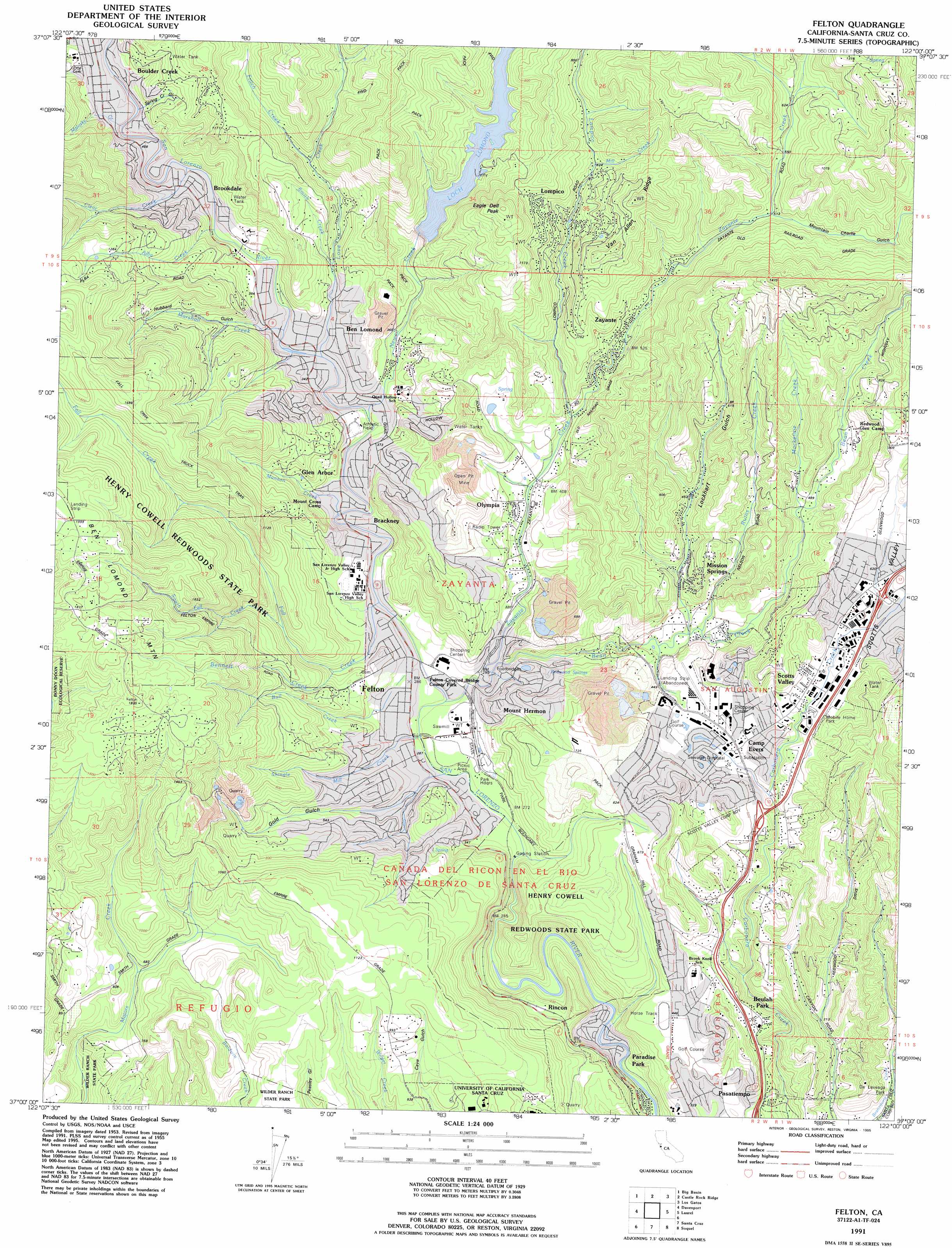
USGS Topo Quad 37122a1 - 1:24,000 scale
| Topo Map Name: | Felton |
| USGS Topo Quad ID: | 37122a1 |
| Print Size: | ca. 21 1/4" wide x 27" high |
| Southeast Coordinates: | 37° N latitude / 122° W longitude |
| Map Center Coordinates: | 37.0625° N latitude / 122.0625° W longitude |
| U.S. State: | CA |
| Filename: | o37122a1.jpg |
| Download Map JPG Image: | Felton topo map 1:24,000 scale |
| Map Type: | Topographic |
| Topo Series: | 7.5´ |
| Map Scale: | 1:24,000 |
| Source of Map Images: | United States Geological Survey (USGS) |
| Alternate Map Versions: |
Felton CA 1955, updated 1961 Download PDF Buy paper map Felton CA 1955, updated 1969 Download PDF Buy paper map Felton CA 1955, updated 1975 Download PDF Buy paper map Felton CA 1955, updated 1980 Download PDF Buy paper map Felton CA 1955, updated 1986 Download PDF Buy paper map Felton CA 1991, updated 1995 Download PDF Buy paper map Felton CA 1998, updated 2002 Download PDF Buy paper map Felton CA 2012 Download PDF Buy paper map Felton CA 2015 Download PDF Buy paper map |
1:24,000 Topo Quads surrounding Felton
La Honda |
Mindego Hill |
Cupertino |
San Jose West |
San Jose East |
Franklin Point |
Big Basin |
Castle Rock Ridge |
Los Gatos |
Santa Teresa Hills |
Ano Nuevo * |
Davenport |
Felton |
Laurel |
Loma Prieta |
Santa Cruz |
Soquel |
Watsonville West |
||
Moss Landing |
> Back to 37122a1 at 1:100,000 scale
> Back to 37122a1 at 1:250,000 scale
> Back to U.S. Topo Maps home
Felton topo map: Gazetteer
Felton: Basins
Big Rock Hole elevation 33m 108′Felton: Bridges
Branciforte Covered Bridge elevation 32m 104′Felton Covered Bridge elevation 75m 246′
Felton: Dams
Newell 23-002 Dam elevation 175m 574′Felton: Parks
Ben Lomond County Park elevation 93m 305′Felton Covered Bridge County Park elevation 78m 255′
Henry Cowell Redwoods State Park elevation 181m 593′
Highlands County Park elevation 84m 275′
Lodato Park elevation 228m 748′
MacDorsa Park elevation 177m 580′
Santa Cruz Big Trees County Park elevation 187m 613′
Siltanen Community Park elevation 213m 698′
Felton: Populated Places
Ben Lomond elevation 101m 331′Beulah Park elevation 139m 456′
Brackney elevation 90m 295′
Brookdale elevation 135m 442′
Camp Evers elevation 159m 521′
Felton elevation 87m 285′
Glen Arbor elevation 102m 334′
Lompico elevation 203m 666′
Mission Springs elevation 149m 488′
Mount Hermon elevation 122m 400′
Olympia elevation 112m 367′
Paradise Park elevation 17m 55′
Pasatiempo elevation 124m 406′
Rincon elevation 92m 301′
Scotts Valley elevation 171m 561′
Zayante elevation 152m 498′
Felton: Post Offices
Ben Lomond Post Office elevation 109m 357′Brookdale Post Office (historical) elevation 135m 442′
Felton Post Office elevation 90m 295′
Mount Hermon Post Office elevation 122m 400′
Scotts Valley Post Office elevation 159m 521′
Zayante Post Office (historical) elevation 152m 498′
Felton: Reservoirs
Lake Lompico elevation 276m 905′Loch Lomond elevation 175m 574′
Spring Lakes elevation 153m 501′
Felton: Ridges
Hogsback elevation 109m 357′Van Allen Ridge elevation 356m 1167′
Felton: Springs
Redwood Springs elevation 140m 459′Felton: Streams
Alba Creek elevation 108m 354′Bean Creek elevation 81m 265′
Bennett Creek elevation 120m 393′
Boulder Brook elevation 90m 295′
Bull Creek elevation 73m 239′
Clear Creek elevation 113m 370′
Deans Creek elevation 159m 521′
Eagle Creek elevation 63m 206′
Fall Creek elevation 75m 246′
Ferndell Creek elevation 77m 252′
Fritch Creek elevation 158m 518′
Gold Gulch Creek elevation 68m 223′
Lompico Creek elevation 107m 351′
Love Creek elevation 90m 295′
Mackenzie Creek elevation 143m 469′
Malosky Creek elevation 120m 393′
Manson Creek elevation 81m 265′
Marshall Creek elevation 95m 311′
Mill Creek elevation 189m 620′
Newell Creek elevation 84m 275′
Powder Mill Creek elevation 5m 16′
Quail Hollow Creek elevation 105m 344′
Ruins Creek elevation 108m 354′
Shingle Mill Creek elevation 69m 226′
Smith Creek elevation 119m 390′
Zayante Creek elevation 71m 232′
Felton: Summits
Eagle Dell Peak elevation 428m 1404′Felton: Trails
Big Rock Hole Trail elevation 51m 167′Buckeye Trail elevation 44m 144′
Diversion Dam Trail elevation 38m 124′
Eagle Creek Trail elevation 135m 442′
Graham Trail elevation 169m 554′
Meadow Trail elevation 72m 236′
Ox Road Trail elevation 95m 311′
Pine Trail elevation 197m 646′
Powder Mill Fire Road Trail elevation 197m 646′
Powder Mill Trail elevation 121m 396′
Redwood Loop Trail elevation 78m 255′
Rincon Fire Road Trail elevation 183m 600′
River Trail elevation 73m 239′
Felton: Valleys
Gold Gulch elevation 83m 272′Hubbard Gulch elevation 115m 377′
Lockhart Gulch elevation 115m 377′
Mountain Charlie Gulch elevation 154m 505′
Scotts Valley elevation 169m 554′
Spring Creek Gulch elevation 155m 508′
Felton: Woods
Big Tree Grove elevation 187m 613′Cathedral Redwoods elevation 85m 278′
Garden of Eden elevation 60m 196′
George Washington Memorial Grove elevation 29m 95′
Felton digital topo map on disk
Buy this Felton topo map showing relief, roads, GPS coordinates and other geographical features, as a high-resolution digital map file on DVD: