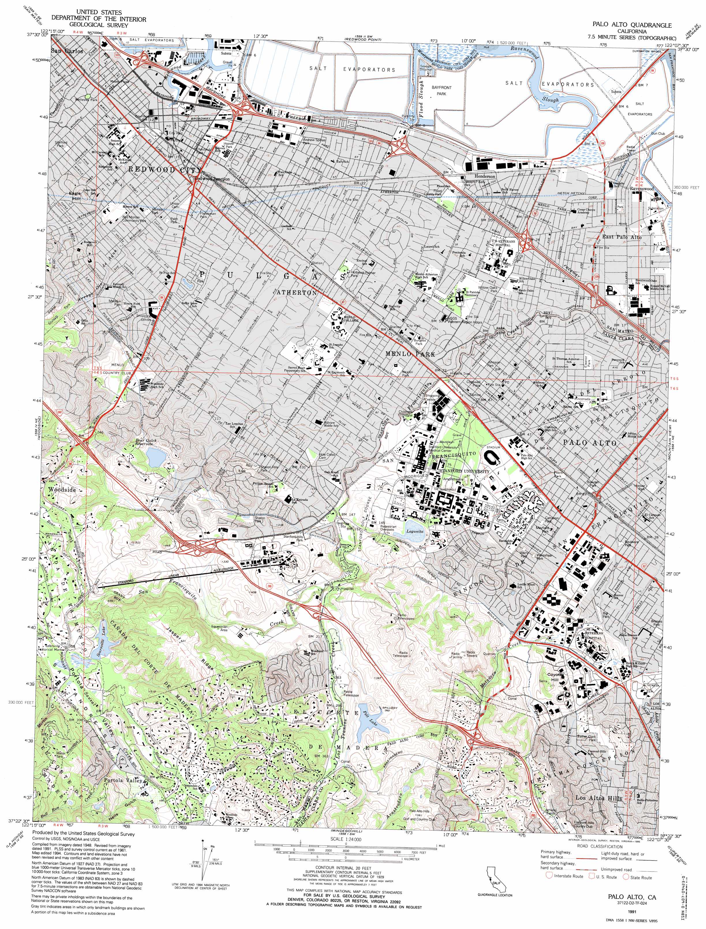
Palo Alto Topo Map California
To zoom in, hover over the map of Palo Alto
USGS Topo Quad 37122d2 - 1:24,000 scale
| Topo Map Name: | Palo Alto |
| USGS Topo Quad ID: | 37122d2 |
| Print Size: | ca. 21 1/4" wide x 27" high |
| Southeast Coordinates: | 37.375° N latitude / 122.125° W longitude |
| Map Center Coordinates: | 37.4375° N latitude / 122.1875° W longitude |
| U.S. State: | CA |
| Filename: | o37122d2.jpg |
| Download Map JPG Image: | Palo Alto topo map 1:24,000 scale |
| Map Type: | Topographic |
| Topo Series: | 7.5´ |
| Map Scale: | 1:24,000 |
| Source of Map Images: | United States Geological Survey (USGS) |
| Alternate Map Versions: |
Palo Alto CA 1953, updated 1955 Download PDF Buy paper map Palo Alto CA 1961, updated 1962 Download PDF Buy paper map Palo Alto CA 1961, updated 1965 Download PDF Buy paper map Palo Alto CA 1961, updated 1969 Download PDF Buy paper map Palo Alto CA 1961, updated 1974 Download PDF Buy paper map Palo Alto CA 1991, updated 1995 Download PDF Buy paper map Palo Alto CA 1991, updated 1995 Download PDF Buy paper map Palo Alto CA 1997, updated 1999 Download PDF Buy paper map Palo Alto CA 2012 Download PDF Buy paper map Palo Alto CA 2015 Download PDF Buy paper map |
1:24,000 Topo Quads surrounding Palo Alto
San Francisco South |
Hunters Point |
San Leandro |
Hayward |
Dublin |
Montara Mountain |
San Mateo |
Redwood Point |
Newark |
Niles |
Half Moon Bay |
Woodside |
Palo Alto |
Mountain View |
Milpitas |
San Gregorio |
La Honda |
Mindego Hill |
Cupertino |
San Jose West |
Pigeon Point |
Franklin Point |
Big Basin |
Castle Rock Ridge |
Los Gatos |
> Back to 37122a1 at 1:100,000 scale
> Back to 37122a1 at 1:250,000 scale
> Back to U.S. Topo Maps home
Palo Alto topo map: Gazetteer
Palo Alto: Airports
Stanford University Hospital Center Heliport elevation 21m 68′Palo Alto: Areas
The Oval elevation 23m 75′Palo Alto: Crossings
Exit 20 elevation 71m 232′Exit 22 elevation 64m 209′
Exit 24 elevation 90m 295′
Exit 25 elevation 87m 285′
Exit 403 elevation 12m 39′
Exit 404 elevation 10m 32′
Exit 406 elevation 6m 19′
Exit 408 elevation 6m 19′
Exit 409 elevation 6m 19′
Palo Alto: Dams
Bear Gulch 581-006 Dam elevation 62m 203′Felt Lake 614-002 Dam elevation 111m 364′
Lagunita 614-003 Dam elevation 43m 141′
Searsville 614 Dam elevation 107m 351′
Palo Alto: Guts
Flood Slough elevation 4m 13′Ravenswood Slough elevation 0m 0′
Palo Alto: Parks
Andrew Spinas Park elevation 3m 9′Angell Field elevation 19m 62′
Arastradero Preserve elevation 132m 433′
Bayfront Park elevation 1m 3′
Berkeley Park elevation 14m 45′
Bol Park elevation 19m 62′
Boulware Park elevation 10m 32′
Bowden Park elevation 9m 29′
Bowling Green Park elevation 13m 42′
Briones Park elevation 21m 68′
Burgess Park elevation 19m 62′
Cameron Park elevation 14m 45′
Camp Fremont Park elevation 24m 78′
Cartan Athletic Fields elevation 19m 62′
Casa De Tableta State Historic Landmark elevation 118m 387′
Cogswell Plaza elevation 18m 59′
Doctor E E Johnson Park elevation 18m 59′
El Camino Field elevation 16m 52′
El Camino Park elevation 20m 65′
Eleanor Park elevation 7m 22′
Elizabeth Gamble Garden Center elevation 11m 36′
Escondido Mall elevation 22m 72′
Esther Clark Park elevation 57m 187′
Fleishman Park elevation 9m 29′
Flood County Park elevation 6m 19′
Galvez Mall elevation 25m 82′
Guinean Sculpture Garden elevation 39m 127′
Hawes Park elevation 10m 32′
Holbrook-Palmer Park elevation 16m 52′
Hoover Park elevation 4m 13′
Hoover Park elevation 5m 16′
Hopkins Creekside Park elevation 19m 62′
Hopkins Park elevation 13m 42′
Jack Farrell Park elevation 4m 13′
Jardin de Ninos Park elevation 5m 16′
Jasper Ridge Biological Preserve elevation 177m 580′
Joseph P Kelly Park elevation 4m 13′
Lasuan Mall elevation 21m 68′
Linden Park elevation 9m 29′
Little House Recreation Center elevation 22m 72′
Lomita Mall elevation 22m 72′
Lytton Plaza elevation 18m 59′
Maddux Park elevation 22m 72′
Mayfield Park elevation 13m 42′
Mezes Plaza elevation 4m 13′
Nealon Park elevation 22m 72′
Palm Park elevation 11m 36′
Pardee Park elevation 8m 26′
Peers Park elevation 12m 39′
Professorville Historic District elevation 13m 42′
Ray Field elevation 14m 45′
Red Morton Community Park elevation 12m 39′
Redding Park elevation 17m 55′
Rinconada Park elevation 8m 26′
Rodin Sculpture Garden elevation 23m 75′
Scott Park elevation 14m 45′
Searsville Historical Marker elevation 111m 364′
Sharon Hills Park elevation 75m 246′
Sharon Park elevation 71m 232′
Stafford Park elevation 14m 45′
Stanford Hills Park elevation 63m 206′
Stanford Stadium elevation 19m 62′
Stulsaft Park elevation 42m 137′
Terman Park elevation 26m 85′
Weisshaar Park elevation 17m 55′
Wellesley Park elevation 9m 29′
Werry Park elevation 19m 62′
White Memorial Plaza elevation 32m 104′
Willow Oaks Park elevation 13m 42′
Palo Alto: Populated Places
Alta Mesa elevation 32m 104′Atherton elevation 18m 59′
Barron Park elevation 15m 49′
Belle Haven elevation 4m 13′
Belle Haven elevation 4m 13′
College Terrace elevation 15m 49′
Crescent Park elevation 9m 29′
Duveneck elevation 5m 16′
East Palo Alto elevation 6m 19′
Embarcadero Oaks elevation 7m 22′
Escondido Village elevation 16m 52′
Evergreen Park elevation 12m 39′
Fair Oaks elevation 8m 26′
Felton Gables elevation 17m 55′
Green Acres elevation 22m 72′
Harbor Village Mobile Home Park elevation 3m 9′
Henderson elevation 4m 13′
Ladera elevation 94m 308′
Le Mar Mobile Home Park elevation 2m 6′
Leland Manor elevation 6m 19′
Lindenwood elevation 13m 42′
Lindenwood elevation 14m 45′
Linfield Oaks elevation 17m 55′
Lloyden Park elevation 14m 45′
Los Altos Hills elevation 89m 291′
Mayfield elevation 10m 32′
Menlo Oaks elevation 12m 39′
Menlo Oaks elevation 12m 39′
Menlo Park elevation 22m 72′
Neal elevation 19m 62′
North Fair Oaks elevation 8m 26′
Palo Alto elevation 9m 29′
Park Forest elevation 19m 62′
Pierce Mitchell Houses elevation 36m 118′
Portola Valley elevation 140m 459′
Professorville elevation 11m 36′
Raines Houses elevation 24m 78′
Ravenswood elevation 4m 13′
Redwood City elevation 6m 19′
Redwood City Mobile Home Park elevation 3m 9′
Redwood Junction elevation 7m 22′
Redwood Mobile Home Park elevation 2m 6′
Redwood Trailer Village elevation 4m 13′
Runnymeade (historical) elevation 5m 16′
Saint Francis elevation 3m 9′
Searsville (historical) elevation 110m 360′
Sequoia Mobile Home Park elevation 6m 19′
Sharon Heights elevation 66m 216′
Southgate elevation 13m 42′
Stanford elevation 23m 75′
Stanford Hills elevation 62m 203′
Stanford Park elevation 22m 72′
Stanford Weekend Acres elevation 47m 154′
The Willows elevation 11m 36′
Trailer Rancho Mobile Home Park elevation 4m 13′
Trailer Villa Mobile Home Park elevation 4m 13′
University Heights elevation 33m 108′
Ventura elevation 10m 32′
Vintage Oaks elevation 15m 49′
West Menlo Park elevation 34m 111′
Westridge elevation 141m 462′
Woodside Highlands elevation 266m 872′
Palo Alto: Post Offices
Downtown Station Redwood City Post Office elevation 4m 13′Oak Grove Station Menlo Park Post Office elevation 23m 75′
Palo Alto Post Office elevation 16m 52′
Redwood City Post Office elevation 5m 16′
Stanford Branch Palo Alto Post Office elevation 30m 98′
Station A Redwood City Post Office elevation 19m 62′
West Menlo Park Branch Menlo Park Post Office elevation 42m 137′
Palo Alto: Reservoirs
Bear Gulch Reservoir elevation 62m 203′Felt Lake elevation 111m 364′
Lagunita elevation 43m 141′
Searsville Lake elevation 107m 351′
Palo Alto: Ridges
Jasper Ridge elevation 176m 577′Palo Alto: Streams
Alambique Creek elevation 111m 364′Arastradero Creek elevation 89m 291′
Arroyo Ojo De Agua elevation 2m 6′
Bear Creek elevation 78m 255′
Bull Run Creek elevation 135m 442′
Cordilleras Creek elevation 2m 6′
Corte Madera Creek elevation 107m 351′
Deer Creek elevation 38m 124′
Los Trancos Creek elevation 50m 164′
Martin Creek elevation 109m 357′
Matadero Creek elevation 8m 26′
Sausal Creek elevation 107m 351′
Palo Alto: Summits
Coyote Hill elevation 112m 367′Eagle Hill elevation 32m 104′
Palo Alto: Valleys
Neils Gulch elevation 143m 469′Portola Valley elevation 111m 364′
Palo Alto: Woods
El Palo Alto elevation 20m 65′Palo Alto digital topo map on disk
Buy this Palo Alto topo map showing relief, roads, GPS coordinates and other geographical features, as a high-resolution digital map file on DVD: