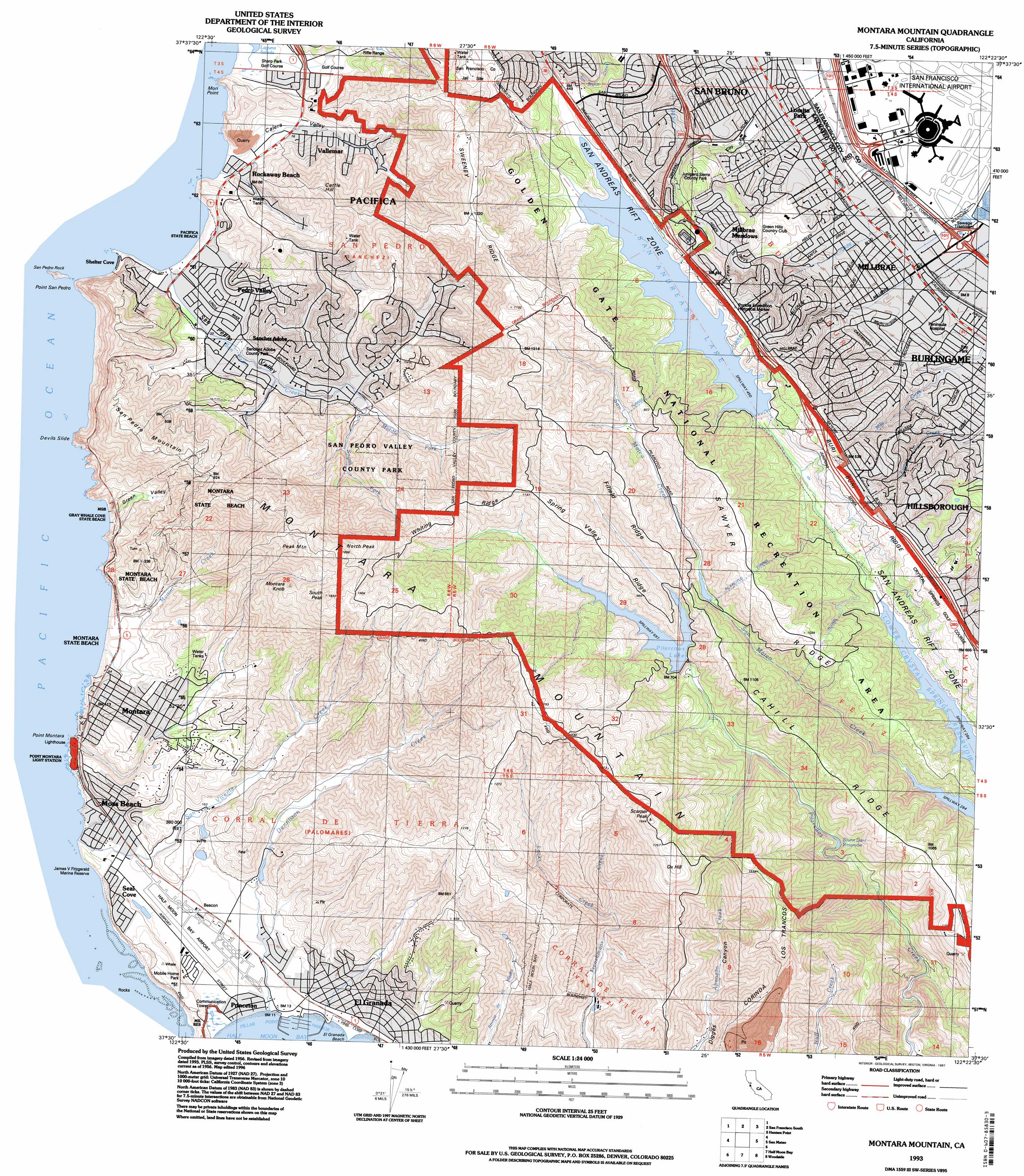
Montara Mountain Topo Map California
To zoom in, hover over the map of Montara Mountain
USGS Topo Quad 37122e4 - 1:24,000 scale
| Topo Map Name: | Montara Mountain |
| USGS Topo Quad ID: | 37122e4 |
| Print Size: | ca. 21 1/4" wide x 27" high |
| Southeast Coordinates: | 37.5° N latitude / 122.375° W longitude |
| Map Center Coordinates: | 37.5625° N latitude / 122.4375° W longitude |
| U.S. State: | CA |
| Filename: | o37122e4.jpg |
| Download Map JPG Image: | Montara Mountain topo map 1:24,000 scale |
| Map Type: | Topographic |
| Topo Series: | 7.5´ |
| Map Scale: | 1:24,000 |
| Source of Map Images: | United States Geological Survey (USGS) |
| Alternate Map Versions: |
Montara Mountain CA 1949 Download PDF Buy paper map Montara Mountain CA 1949, updated 1957 Download PDF Buy paper map Montara Mountain CA 1956, updated 1957 Download PDF Buy paper map Montara Mountain CA 1956, updated 1961 Download PDF Buy paper map Montara Mountain CA 1956, updated 1969 Download PDF Buy paper map Montara Mountain CA 1956, updated 1975 Download PDF Buy paper map Montara Mountain CA 1956, updated 1981 Download PDF Buy paper map Montara Mountain CA 1993, updated 1997 Download PDF Buy paper map Montara Mountain CA 1997, updated 1999 Download PDF Buy paper map Montara Mountain CA 2012 Download PDF Buy paper map Montara Mountain CA 2015 Download PDF Buy paper map |
1:24,000 Topo Quads surrounding Montara Mountain
Point Bonita |
San Francisco North |
Oakland West |
Oakland East |
|
San Francisco South |
Hunters Point |
San Leandro |
||
Montara Mountain |
San Mateo |
Redwood Point |
||
Half Moon Bay |
Woodside |
Palo Alto |
||
San Gregorio |
La Honda |
Mindego Hill |
> Back to 37122e1 at 1:100,000 scale
> Back to 37122a1 at 1:250,000 scale
> Back to U.S. Topo Maps home
Montara Mountain topo map: Gazetteer
Montara Mountain: Airports
Peninsula Hospital Heliport elevation 22m 72′San Francisco International Airport elevation 4m 13′
Montara Mountain: Beaches
El Granada Beach elevation 0m 0′Rockaway Beach elevation 3m 9′
Montara Mountain: Capes
Mori Point elevation 34m 111′San Francisco Peninsula elevation 177m 580′
Montara Mountain: Crossings
Exit 39 elevation 193m 633′Exit 41 elevation 150m 492′
Exit 42 elevation 83m 272′
Exit 421 elevation 2m 6′
Exit 422 elevation 4m 13′
Exit 505A elevation 19m 62′
Montara Mountain: Dams
Burlingame 2014-002 Dam elevation 97m 318′Pilarcitos 10-008 Dam elevation 214m 702′
San Andreas 10-010 Dam elevation 138m 452′
Montara Mountain: Parks
Bayside Park elevation 8m 26′Belle Air Park elevation 5m 16′
Buckeye Park elevation 119m 390′
Calera Creek Park elevation 51m 167′
Central Park elevation 24m 78′
Cooper Field elevation 80m 262′
Cuernavaca Park elevation 170m 557′
Fairway Park elevation 31m 101′
Glenview Park elevation 113m 370′
Green Hills Park elevation 25m 82′
Grundy Park elevation 25m 82′
Hoover Playground elevation 57m 187′
Lions Park elevation 51m 167′
Lions Park elevation 3m 9′
Marina Vista Park elevation 7m 22′
Millbrae Meadows Park elevation 72m 236′
Mills Creek Canyon Park elevation 60m 196′
Mills Estate Park elevation 124m 406′
North Park elevation 118m 387′
Oddstad City Park elevation 60m 196′
Portola Expedition Historical Marker elevation 165m 541′
Ray Park elevation 13m 42′
Rotary Park elevation 80m 262′
San Francisco Bay Discovery Site elevation 371m 1217′
San Francisco State Fish and Game Refuge elevation 296m 971′
San Pedro Valley County Park elevation 178m 583′
Sanchez Park elevation 26m 85′
Schultz Park elevation 55m 180′
Sharp Park elevation 51m 167′
Skyline Park elevation 166m 544′
Tonini Field elevation 68m 223′
Waugh Park elevation 60m 196′
White Field Park elevation 18m 59′
Montara Mountain: Populated Places
El Granada elevation 12m 39′El Granada Mobile Home Park elevation 9m 29′
Fairway Park elevation 12m 39′
Hillsborough elevation 98m 321′
Linda Mar elevation 35m 114′
Lomita Park elevation 9m 29′
Millbrae elevation 10m 32′
Millbrae Meadows elevation 84m 275′
Pacifica elevation 25m 82′
Pedro Valley elevation 6m 19′
Princeton elevation 6m 19′
Rockaway Beach elevation 14m 45′
Vallemar elevation 39m 127′
Montara Mountain: Post Offices
El Granada Post Office elevation 15m 49′Linda Mar Station Pacifica Post Office elevation 9m 29′
Millbrae Post Office elevation 8m 26′
Montara Mountain: Reservoirs
Pilarcitos Lake elevation 214m 702′San Andreas Lake elevation 138m 452′
Spencer Lake elevation 93m 305′
Stone Dam Reservoir elevation 156m 511′
Montara Mountain: Ridges
Buri Buri Ridge elevation 187m 613′Cahill Ridge elevation 357m 1171′
Corinda Los Trancos elevation 348m 1141′
Fifield Ridge elevation 358m 1174′
Montara Mountain elevation 584m 1916′
Sawyer Ridge elevation 350m 1148′
Spring Valley Ridge elevation 326m 1069′
Sweeney Ridge elevation 367m 1204′
Whiting Ridge elevation 289m 948′
Montara Mountain: Streams
Brooks Creek elevation 23m 75′Deer Creek elevation 8m 26′
Denniston Creek elevation 3m 9′
Locks Creek elevation 106m 347′
Middle Fork San Pedro Creek elevation 50m 164′
North Fork San Pedro Creek elevation 49m 160′
San Agustin Creek elevation 30m 98′
South Fork San Pedro Creek elevation 49m 160′
Montara Mountain: Summits
Cattle Hill elevation 244m 800′Montara Knob elevation 487m 1597′
North Peak elevation 570m 1870′
Ox Hill elevation 542m 1778′
Peak Mountain elevation 545m 1788′
Scarpet Peak elevation 586m 1922′
South Peak elevation 545m 1788′
Montara Mountain: Trails
Baquaiano Trail elevation 290m 951′Brooks Falls Overlook Trail elevation 95m 311′
Hazelnut Trail elevation 325m 1066′
Mori Ridge Trail elevation 275m 902′
Old Trout Farm Trail elevation 86m 282′
Plaskon Nature Trail elevation 188m 616′
Sweeney Ridge Trail elevation 371m 1217′
Valley View Trail elevation 295m 967′
Weiler Ranch Road Trail elevation 81m 265′
Montara Mountain: Tunnels
Pilarcitos Tunnel elevation 351m 1151′Montara Mountain: Valleys
Calera Valley elevation 4m 13′Montara Mountain digital topo map on disk
Buy this Montara Mountain topo map showing relief, roads, GPS coordinates and other geographical features, as a high-resolution digital map file on DVD: