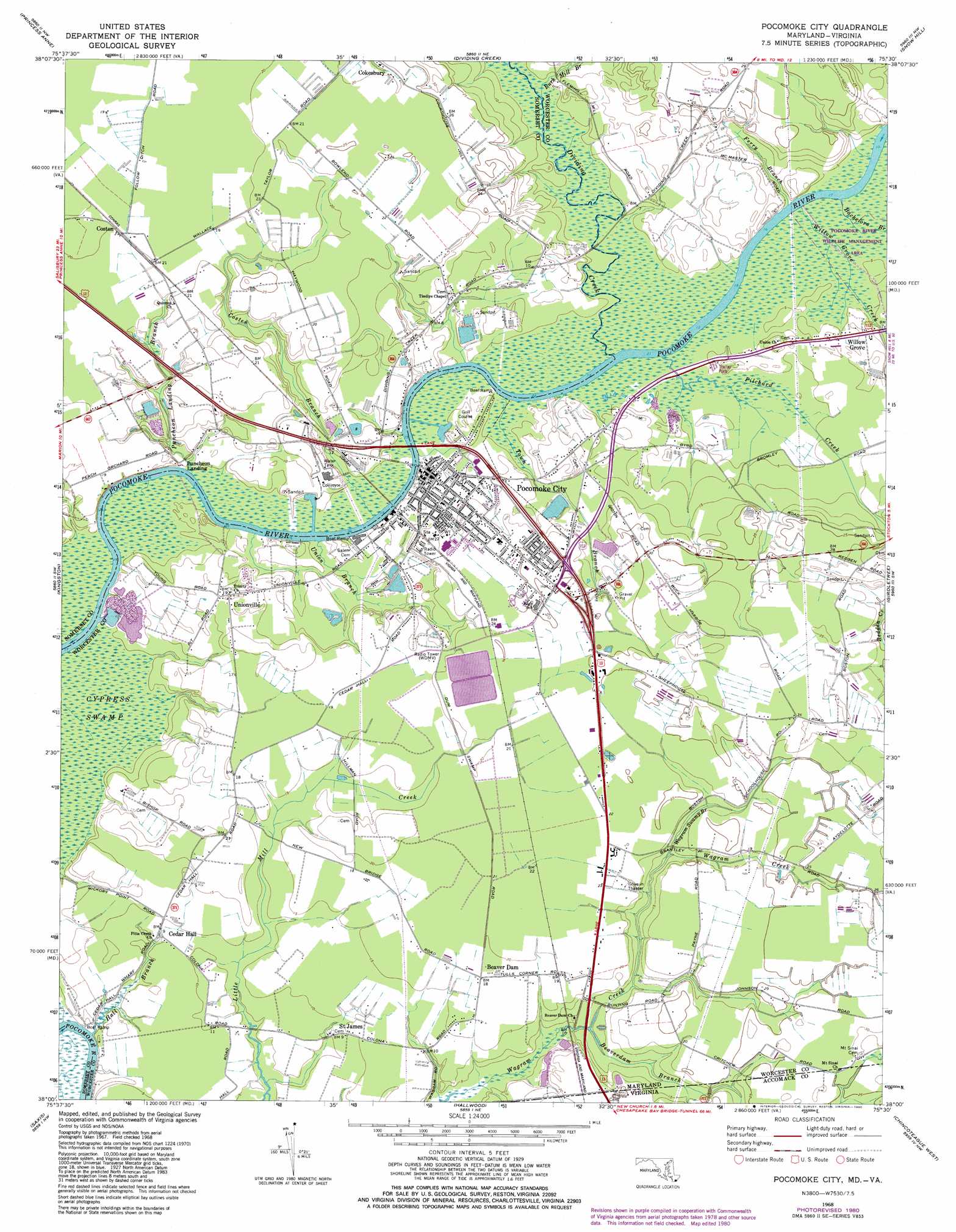
Pocomoke City Topo Map Maryland
To zoom in, hover over the map of Pocomoke City
USGS Topo Quad 38075a5 - 1:24,000 scale
| Topo Map Name: | Pocomoke City |
| USGS Topo Quad ID: | 38075a5 |
| Print Size: | ca. 21 1/4" wide x 27" high |
| Southeast Coordinates: | 38° N latitude / 75.5° W longitude |
| Map Center Coordinates: | 38.0625° N latitude / 75.5625° W longitude |
| U.S. States: | MD, VA |
| Filename: | o38075a5.jpg |
| Download Map JPG Image: | Pocomoke City topo map 1:24,000 scale |
| Map Type: | Topographic |
| Topo Series: | 7.5´ |
| Map Scale: | 1:24,000 |
| Source of Map Images: | United States Geological Survey (USGS) |
| Alternate Map Versions: |
Pocomoke City MD 1953 Download PDF Buy paper map Pocomoke City MD 1953 Download PDF Buy paper map Pocomoke City MD 1968, updated 1972 Download PDF Buy paper map Pocomoke City MD 1968, updated 1980 Download PDF Buy paper map Pocomoke City MD 2011 Download PDF Buy paper map Pocomoke City MD 2014 Download PDF Buy paper map Pocomoke City MD 2016 Download PDF Buy paper map |
1:24,000 Topo Quads surrounding Pocomoke City
Wetipquin |
Eden |
Salisbury |
Wango |
Ninepin Branch |
Monie |
Princess Anne |
Dividing Creek |
Snow Hill |
Public Landing |
Marion |
Kingston |
Pocomoke City |
Girdletree |
Boxiron |
Crisfield |
Saxis |
Hallwood |
Chincoteague West |
Chincoteague East |
Chesconessex |
Parksley |
Bloxom |
Wallops Island |
> Back to 38075a1 at 1:100,000 scale
> Back to 38074a1 at 1:250,000 scale
> Back to U.S. Topo Maps home
Pocomoke City topo map: Gazetteer
Pocomoke City: Airports
Beverly Airport elevation 2m 6′Fairs Airport elevation 6m 19′
Pocomoke City: Bridges
Pocomoke City Bridge elevation 0m 0′Pocomoke City: Crossings
Cottingham Ferry (historical) elevation 0m 0′Pocomoke City: Dams
Pocomoke City Sewage Lagoon Number One Dam elevation 6m 19′Pocomoke City Sewage Lagoon Number Two Dam elevation 8m 26′
Pocomoke City: Parks
Cypress Park elevation 1m 3′Newtown Recreation Area elevation 7m 22′
Pocomoke City: Populated Places
Cassatt elevation 4m 13′Costen elevation 6m 19′
Harbor Acres elevation 9m 29′
Homewood elevation 8m 26′
New Bridge Haven elevation 5m 16′
Pocomoke City elevation 2m 6′
Puncheon Landing elevation 1m 3′
Unionville elevation 6m 19′
Unionville Heights elevation 4m 13′
West Pocomoke elevation 6m 19′
Willow Grove elevation 4m 13′
Pocomoke City: Post Offices
Pocomoke City Post Office elevation 3m 9′Pocomoke City: Streams
Bachelors Branch elevation 1m 3′Beaverdam Branch elevation 2m 6′
Beaverdam Branch elevation 1m 3′
Burk Mill Branch elevation 0m 0′
Costen Branch elevation 0m 0′
Dividing Creek elevation 0m 0′
Ferry Branch elevation 0m 0′
Hall Branch elevation 1m 3′
Pilchard Creek elevation 1m 3′
Pitts Creek elevation 1m 3′
Puncheon Landing Branch elevation 1m 3′
Town Branch elevation 0m 0′
Union Branch elevation 1m 3′
Wagram Creek elevation 1m 3′
Wagram Swamp Branch elevation 4m 13′
Willow Grove Creek elevation 1m 3′
Pocomoke City: Swamps
Beaverdam Swamp elevation 3m 9′Dennis Swamp elevation 0m 0′
Wagram Swamp elevation 6m 19′
Pocomoke City digital topo map on disk
Buy this Pocomoke City topo map showing relief, roads, GPS coordinates and other geographical features, as a high-resolution digital map file on DVD:
Atlantic Coast (NY, NJ, PA, DE, MD, VA, NC)
Buy digital topo maps: Atlantic Coast (NY, NJ, PA, DE, MD, VA, NC)
 map DVD")