Tingles Island Topo Map Maryland
To zoom in, hover over the map of Tingles Island
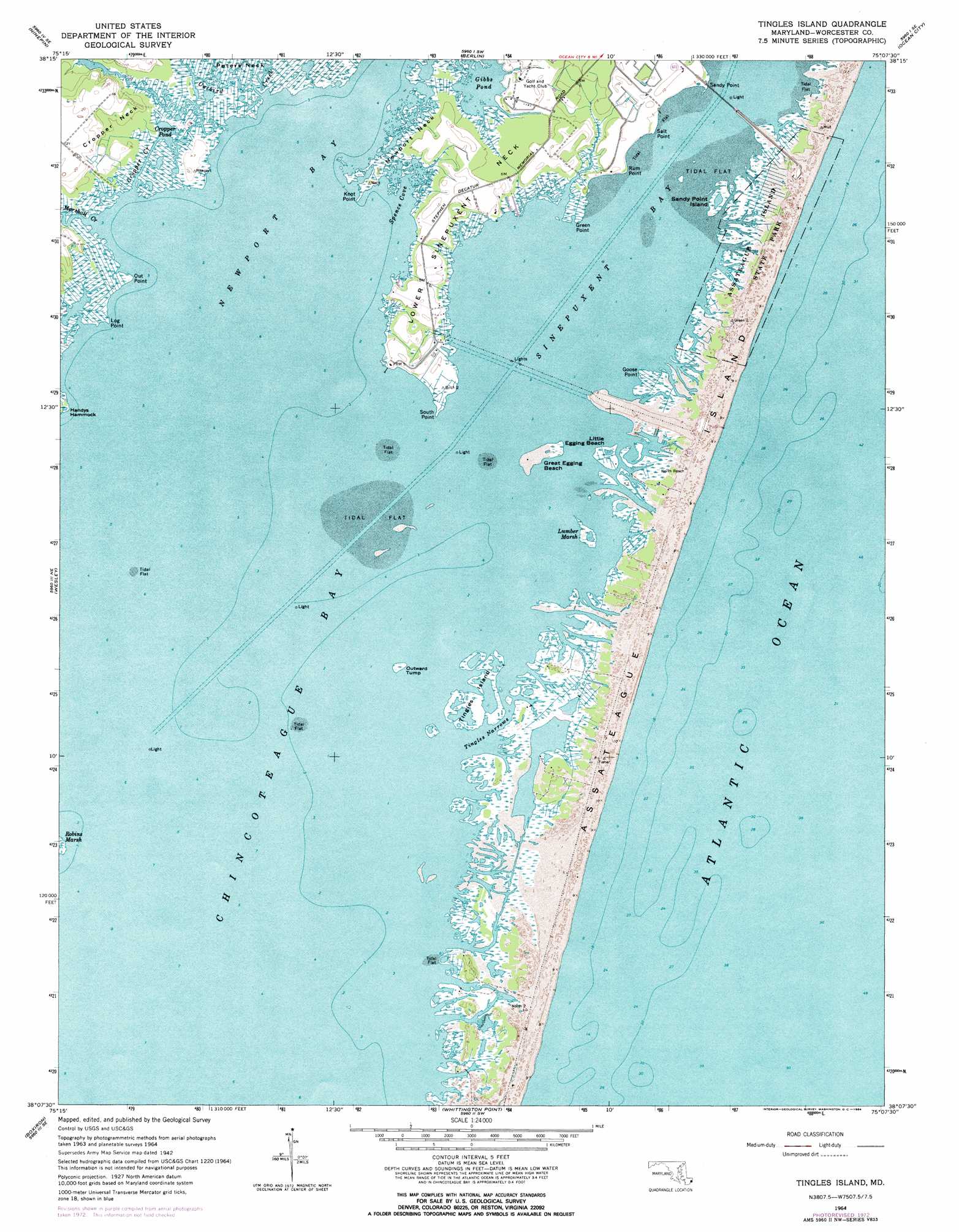
USGS Topo Quad 38075b2 - 1:24,000 scale
| Topo Map Name: | Tingles Island |
| USGS Topo Quad ID: | 38075b2 |
| Print Size: | ca. 21 1/4" wide x 27" high |
| Southeast Coordinates: | 38.125° N latitude / 75.125° W longitude |
| Map Center Coordinates: | 38.1875° N latitude / 75.1875° W longitude |
| U.S. State: | MD |
| Filename: | o38075b2.jpg |
| Download Map JPG Image: | Tingles Island topo map 1:24,000 scale |
| Map Type: | Topographic |
| Topo Series: | 7.5´ |
| Map Scale: | 1:24,000 |
| Source of Map Images: | United States Geological Survey (USGS) |
| Alternate Map Versions: |
Tingles Island MD 1942, updated 1962 Download PDF Buy paper map Tingles Island MD 1964, updated 1966 Download PDF Buy paper map Tingles Island MD 1964, updated 1972 Download PDF Buy paper map Tingles Island MD 1964, updated 1984 Download PDF Buy paper map Tingles Island MD 1964, updated 1984 Download PDF Buy paper map Tingles Island MD 1998, updated 2000 Download PDF Buy paper map Tingles Island MD 2011 Download PDF Buy paper map Tingles Island MD 2014 Download PDF Buy paper map Tingles Island MD 2016 Download PDF Buy paper map |
1:24,000 Topo Quads surrounding Tingles Island
Pittsville |
Whaleysville |
Selbyville |
Assawoman Bay |
|
Wango |
Ninepin Branch |
Berlin |
Ocean City |
|
Snow Hill |
Public Landing |
Tingles Island |
||
Girdletree |
Boxiron |
Whittington Point |
||
Chincoteague West |
Chincoteague East |
> Back to 38075a1 at 1:100,000 scale
> Back to 38074a1 at 1:250,000 scale
> Back to U.S. Topo Maps home
Tingles Island topo map: Gazetteer
Tingles Island: Bays
Newport Bay elevation 0m 0′Spence Cove elevation 0m 0′
Tingles Island: Beaches
Great Egging Beach elevation 0m 0′Little Egging Beach elevation 0m 0′
Tingles Island: Capes
Goose Point elevation 0m 0′Green Point elevation 0m 0′
Island Point elevation 0m 0′
Island Point elevation 2m 6′
Knot Point elevation 0m 0′
Log Point elevation 0m 0′
Lower Sinepuxent Neck elevation 1m 3′
Newport Neck elevation 2m 6′
Out Point elevation 0m 0′
Peters Neck elevation 0m 0′
Rum Point elevation 2m 6′
Salt Point elevation 1m 3′
Sandy Point elevation 3m 9′
South Point elevation 0m 0′
Tingles Island: Channels
Tingles Narrows elevation 0m 0′Tingles Island: Islands
Beacon Clumps (historical) elevation 0m 0′Cropper Island elevation 2m 6′
Crow Tump elevation 0m 0′
Great Egging Island elevation 1m 3′
Little Egging Island elevation 0m 0′
Lumber Marsh Island elevation 0m 0′
Outward Tump elevation 0m 0′
Sandy Point Island elevation 0m 0′
Tingles Island elevation 0m 0′
Tingles Island: Lakes
Cropper Pond elevation 0m 0′Gibbs Pond elevation -3m -10′
Tingles Island: Parks
Assateague State Park elevation 1m 3′Tingles Island: Populated Places
Genezer Estates elevation 0m 0′Newport South elevation 2m 6′
Tingles Island: Streams
Bassett Creek elevation 2m 6′Catbird Creek elevation -4m -14′
Cropper Creek elevation 0m 0′
Green Point Creek elevation 0m 0′
Marshall Creek elevation 0m 0′
Porter Creek elevation 0m 0′
Tingles Island: Swamps
Lumber Marsh elevation 0m 0′Robins Marsh elevation 0m 0′
Tingles Island digital topo map on disk
Buy this Tingles Island topo map showing relief, roads, GPS coordinates and other geographical features, as a high-resolution digital map file on DVD:
Atlantic Coast (NY, NJ, PA, DE, MD, VA, NC)
Buy digital topo maps: Atlantic Coast (NY, NJ, PA, DE, MD, VA, NC)
 map DVD")