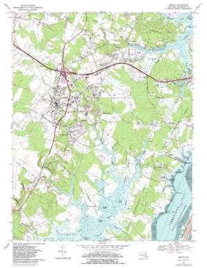
Berlin Topo Map Maryland
To zoom in, hover over the map of Berlin
USGS Topo Quad 38075c2 - 1:24,000 scale
| Topo Map Name: | Berlin |
| USGS Topo Quad ID: | 38075c2 |
| Print Size: | ca. 21 1/4" wide x 27" high |
| Southeast Coordinates: | 38.25° N latitude / 75.125° W longitude |
| Map Center Coordinates: | 38.3125° N latitude / 75.1875° W longitude |
| U.S. State: | MD |
| Filename: | o38075c2.jpg |
| Download Map JPG Image: | Berlin topo map 1:24,000 scale |
| Map Type: | Topographic |
| Topo Series: | 7.5´ |
| Map Scale: | 1:24,000 |
| Source of Map Images: | United States Geological Survey (USGS) |
| Alternate Map Versions: |
Berlin MD 1943, updated 1962 Download PDF Buy paper map Berlin MD 1967, updated 1969 Download PDF Buy paper map Berlin MD 1967, updated 1973 Download PDF Buy paper map Berlin MD 1967, updated 1982 Download PDF Buy paper map Berlin MD 2011 Download PDF Buy paper map Berlin MD 2014 Download PDF Buy paper map Berlin MD 2016 Download PDF Buy paper map |
1:24,000 Topo Quads surrounding Berlin
> Back to 38075a1 at 1:100,000 scale
> Back to 38074a1 at 1:250,000 scale
> Back to U.S. Topo Maps home
Berlin topo map: Gazetteer
Berlin: Airports
Buntings Field elevation 9m 29′Berlin: Bays
Grays Cove elevation 0m 0′Greys Inlet elevation 1m 3′
Holland Creek elevation -1m -4′
Orchard Creek elevation 0m 0′
Sandy Cove elevation 0m 0′
Sinepuxent Bay elevation 0m 0′
Berlin: Capes
Fassett Point elevation 0m 0′Golden Quarter Neck elevation 2m 6′
Grays Point elevation 0m 0′
Gum Point elevation 0m 0′
Newport Neck elevation 1m 3′
Porter Neck elevation 4m 13′
Sandy Point elevation 0m 0′
Sinepuxent Neck elevation 0m 0′
Turville Neck elevation 3m 9′
Wallops Neck elevation 0m 0′
Berlin: Crossings
Newbay Ferry (historical) elevation 0m 0′Berlin: Guts
Herring Gut elevation 0m 0′Berlin: Harbors
Dutch Harbor elevation 0m 0′Snug Harbor elevation 1m 3′
Berlin: Islands
Ayer Island elevation 0m 0′Gambage Island elevation 0m 0′
Horse Island elevation 0m 0′
Berlin: Lakes
Buddy Pond elevation 0m 0′Maceasin Pond elevation -2m -7′
Wrights Pond elevation 11m 36′
Berlin: Parks
Berlin Commercial Historic District elevation 13m 42′Frontier Amusement Park elevation 3m 9′
Stephen Decatur Monument elevation 8m 26′
Berlin: Populated Places
Albatross Mobile Home Park elevation 0m 0′Berlin elevation 11m 36′
Briddletown elevation 7m 22′
Dills Acres elevation 2m 6′
Douglynne Woods elevation 11m 36′
Franklin Heights elevation 11m 36′
Friendship elevation 8m 26′
Friendship Estates elevation 10m 32′
Germantown elevation 9m 29′
Golf Club Shores elevation 1m 3′
Grays Corner elevation 3m 9′
Hayes Landing elevation 2m 6′
Highland Park elevation 5m 16′
Holly Grove elevation 3m 9′
Ironshire elevation 10m 32′
Kitts Hill elevation 6m 19′
Lake Haven Mobile Home Park elevation 8m 26′
Lewis Corner elevation 2m 6′
Morris Mobile Home Park elevation 3m 9′
Newport Hills elevation 2m 6′
Pomona Heights elevation 12m 39′
Saint Martin elevation 11m 36′
Salt Grass Cove elevation 1m 3′
Sherwood Forest elevation 3m 9′
Silver Lake Mobile Home Park elevation 1m 3′
Sinepuxent elevation 3m 9′
Snug Harbor elevation 0m 0′
Taylorville elevation 3m 9′
Trappe elevation 3m 9′
Wood Duck Isle elevation 3m 9′
Berlin: Post Offices
Berlin Post Office elevation 14m 45′Berlin: Reservoirs
Silver Lake elevation 1m 3′Trappe Mill Pond (historical) elevation 1m 3′
Berlin: Streams
Ayer Creek elevation 0m 0′Bat Creek elevation 4m 13′
Battle Branch elevation 1m 3′
Beaverdam Creek elevation 7m 22′
Crippen Branch elevation 2m 6′
Deals Branch elevation 0m 0′
Goody Hill Branch elevation 1m 3′
Grays Creek elevation 0m 0′
Herring Creek elevation 0m 0′
Hudson Branch elevation 3m 9′
Jake Gut elevation 0m 0′
Jenkins Creek elevation 0m 0′
Kitts Branch elevation 5m 16′
Manklin Creek elevation 0m 0′
Mud Creek elevation 1m 3′
Newport Creek elevation 1m 3′
Poplartown Branch elevation 1m 3′
Taylorville Creek elevation 1m 3′
Trappe Creek elevation 0m 0′
Tukesbury Branch elevation 3m 9′
Berlin: Swamps
Bassett Millpond elevation 1m 3′Hollygrove Swamp elevation 4m 13′
Berlin digital topo map on disk
Buy this Berlin topo map showing relief, roads, GPS coordinates and other geographical features, as a high-resolution digital map file on DVD:
Atlantic Coast (NY, NJ, PA, DE, MD, VA, NC)
Buy digital topo maps: Atlantic Coast (NY, NJ, PA, DE, MD, VA, NC)


