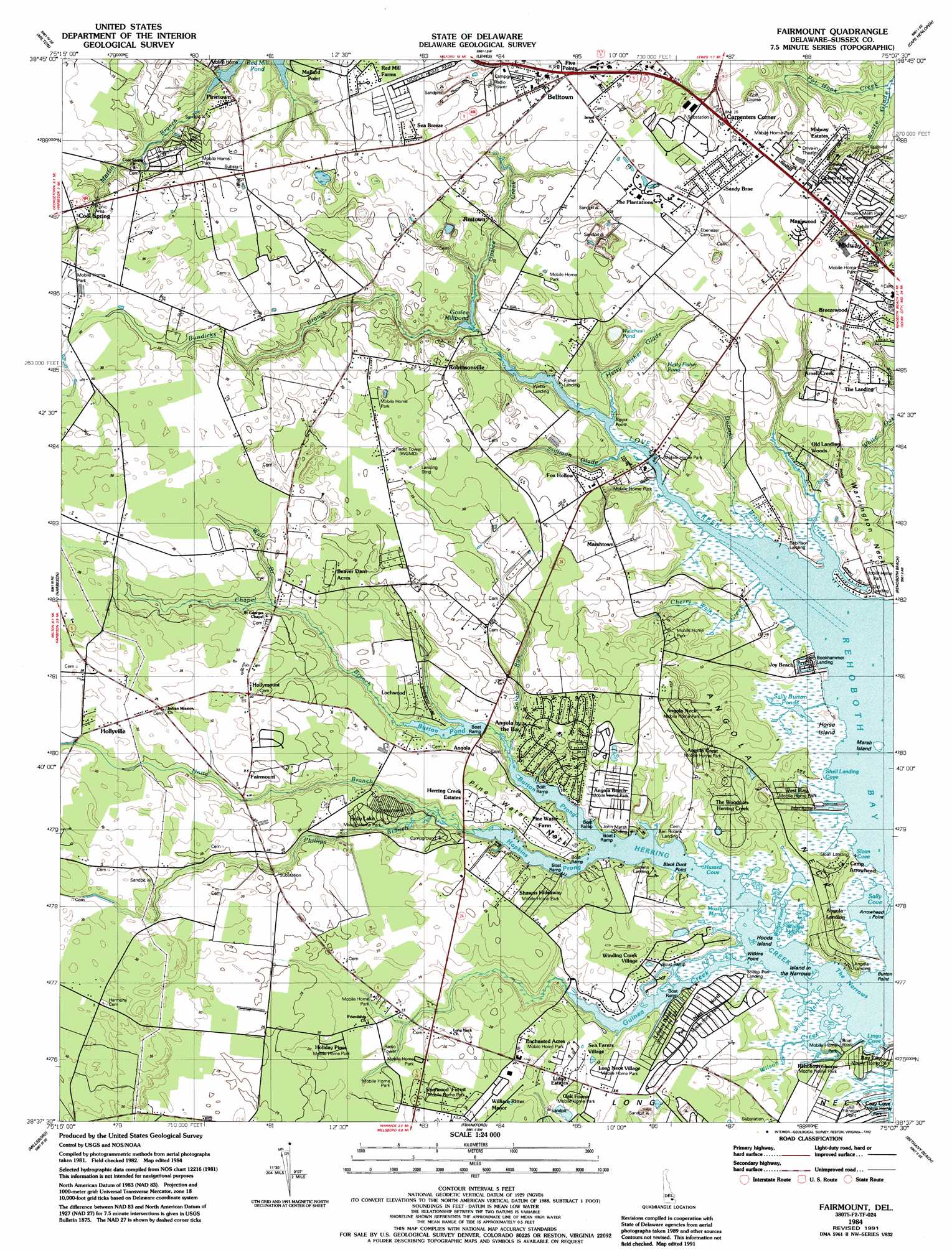
Fairmount Topo Map Delaware
To zoom in, hover over the map of Fairmount
USGS Topo Quad 38075f2 - 1:24,000 scale
| Topo Map Name: | Fairmount |
| USGS Topo Quad ID: | 38075f2 |
| Print Size: | ca. 21 1/4" wide x 27" high |
| Southeast Coordinates: | 38.625° N latitude / 75.125° W longitude |
| Map Center Coordinates: | 38.6875° N latitude / 75.1875° W longitude |
| U.S. State: | DE |
| Filename: | o38075f2.jpg |
| Download Map JPG Image: | Fairmount topo map 1:24,000 scale |
| Map Type: | Topographic |
| Topo Series: | 7.5´ |
| Map Scale: | 1:24,000 |
| Source of Map Images: | United States Geological Survey (USGS) |
| Alternate Map Versions: |
Fairmount DE 1943, updated 1948 Download PDF Buy paper map Fairmount DE 1948, updated 1949 Download PDF Buy paper map Fairmount DE 1954, updated 1956 Download PDF Buy paper map Fairmount DE 1954, updated 1972 Download PDF Buy paper map Fairmount DE 1954, updated 1982 Download PDF Buy paper map Fairmount DE 1984, updated 1984 Download PDF Buy paper map Fairmount DE 1984, updated 1985 Download PDF Buy paper map Fairmount DE 1984, updated 1992 Download PDF Buy paper map Fairmount DE 2011 Download PDF Buy paper map Fairmount DE 2014 Download PDF Buy paper map Fairmount DE 2016 Download PDF Buy paper map |
1:24,000 Topo Quads surrounding Fairmount
Milford |
Mispillion River |
Cape May |
||
Ellendale |
Milton |
Lewes |
Cape Henlopen |
|
Georgetown |
Harbeson |
Fairmount |
Rehoboth Beach |
|
Trap Pond |
Millsboro |
Frankford |
Bethany Beach |
|
Pittsville |
Whaleysville |
Selbyville |
Assawoman Bay |
> Back to 38075e1 at 1:100,000 scale
> Back to 38074a1 at 1:250,000 scale
> Back to U.S. Topo Maps home
Fairmount topo map: Gazetteer
Fairmount: Airports
Cozy Cove Airport (historical) elevation 4m 13′Rehoboth Aircrafters Airport (historical) elevation 7m 22′
Fairmount: Bays
Hazard Cove elevation 0m 0′Lingo Cove elevation 0m 0′
Sally Cove elevation 0m 0′
Shell Landing Cove elevation 0m 0′
Sloan Cove elevation 0m 0′
Fairmount: Beaches
Joy Beach elevation 0m 0′Fairmount: Bridges
Love Creek Bridge elevation 0m 0′Fairmount: Capes
Angola Neck elevation 1m 3′Arrowhead Point elevation 0m 0′
Burton Point elevation 0m 0′
Long Neck elevation 5m 16′
Pine Water Neck elevation 4m 13′
Sipps Point elevation 0m 0′
Warrington Neck elevation 3m 9′
Wilkins Point elevation 0m 0′
Fairmount: Channels
The Narrows elevation 0m 0′Fairmount: Dams
Burton Pond Dam elevation 2m 6′Goslee Mill Pond Dam elevation 1m 3′
Fairmount: Guts
Hetty Fisher Glade elevation 4m 13′Stillman Glade elevation 2m 6′
Fairmount: Islands
Hoods Island elevation 0m 0′Horse Island elevation 2m 6′
Island in the Narrows elevation 0m 0′
Island in the Narrows elevation 0m 0′
Marsh Island elevation 0m 0′
Fairmount: Lakes
Hetty Fisher Pond elevation 3m 9′Sally Burton Ponds elevation 0m 0′
Welches Pond elevation 3m 9′
Wolfpit Pond elevation 0m 0′
Fairmount: Populated Places
Angola Acres II Mobile Home Park elevation 9m 29′Angola Beach Mobile Home Park elevation 4m 13′
Angola by the Bay elevation 7m 22′
Angola Crest II Mobile Home Park elevation 7m 22′
Angola Crest Mobile Home Park elevation 7m 22′
Angola Landing elevation 1m 3′
Angola Neck Park Mobile Home Park elevation 7m 22′
Arabian Acres elevation 7m 22′
Arbre Park Mobile Home Park elevation 9m 29′
Aspen Meadows elevation 9m 29′
Bay City Mobile Home Park elevation 1m 3′
Bay Shore Hills elevation 1m 3′
Beaver Dam Acres elevation 7m 22′
Belltown elevation 8m 26′
Ben Robins Landing elevation 3m 9′
Bookhammer Landing elevation 1m 3′
Breezewood elevation 8m 26′
Carpenters Corner elevation 8m 26′
Colonial East Mobile Home Park elevation 9m 29′
Conley Chapel Village Mobile Home Park elevation 8m 26′
Cool Spring elevation 9m 29′
Cool Spring Farms Mobile Home Park elevation 10m 32′
Country Village elevation 9m 29′
Cozy Cove Mobile Home Park elevation 1m 3′
Danfield Acres elevation 10m 32′
Enchanted Acres Mobile Home Park elevation 6m 19′
Fairmount elevation 9m 29′
Fisher Landing elevation 3m 9′
Five Points elevation 8m 26′
Fox Hollow elevation 4m 13′
Goslee Mill elevation 1m 3′
Greens Landing elevation 2m 6′
Herring Creek Estates elevation 5m 16′
Herring Landing elevation 2m 6′
Holiday Pines elevation 6m 19′
Holiday Pines Mobile Home Park elevation 6m 19′
Holly Pines Mobile Home Park elevation 6m 19′
Hollymount elevation 9m 29′
Hollyville elevation 10m 32′
Hollyville Acres elevation 10m 32′
Indian Mission elevation 10m 32′
Jimtown elevation 6m 19′
John Marsh Landing elevation 1m 3′
Leisure Point Mobile Home Park elevation 4m 13′
Lingo Estate Mobile Home Park elevation 6m 19′
Lochwood elevation 4m 13′
Log Cabin Mobile Home Park elevation 7m 22′
Long Acres elevation 6m 19′
Long Neck Village Mobile Home Park elevation 4m 13′
Mallard Point elevation 6m 19′
Maplewood elevation 9m 29′
Marshtown elevation 6m 19′
Mastens Heights Mobile Home Park elevation 7m 22′
Midway elevation 8m 26′
Midway Estates elevation 8m 26′
Midway Park elevation 8m 26′
Midway Park Subdivision elevation 8m 26′
Nanticoke Shores Mobile Home Park elevation 2m 6′
Nassau Park Mobile Home Park elevation 8m 26′
Oak Forest Mobile Home Park elevation 5m 16′
Old Landing elevation 1m 3′
Old Landing Woods elevation 3m 9′
Pine Valley Mobile Home Park elevation 7m 22′
Pine Water Farm elevation 4m 13′
Pine Water Landing elevation 1m 3′
Pinetown elevation 6m 19′
Pots Nets North Mobile Home Park elevation 4m 13′
Red Mill Farms elevation 9m 29′
Rehoboth Shores Mobile Home Park elevation 1m 3′
Robinson Landing elevation 1m 3′
Robinsonville elevation 6m 19′
Sandy Brae elevation 8m 26′
Sea Farers Village elevation 6m 19′
Sea Spray Village elevation 9m 29′
Shawns Hideaway Mobile Home Park elevation 6m 19′
Sheep Pen Landing elevation 1m 3′
Shell Landing elevation 2m 6′
Sherwood Forest Mobile Home Park elevation 6m 19′
Sloan Landing elevation 3m 9′
The Landing elevation 9m 29′
The Plantations elevation 8m 26′
The Willows elevation 7m 22′
The Woods on Herring Creek elevation 3m 9′
Tri-State Mobile Home Park elevation 5m 16′
Truitts Midway Development elevation 9m 29′
Webb Landing elevation 4m 13′
West Bay Park Mobile Home Park elevation 4m 13′
William Ritter Manor elevation 6m 19′
Winding Creek Village elevation 3m 9′
Woods Edge elevation 4m 13′
Fairmount: Reservoirs
Burton Pond elevation 2m 6′Goslee Mill Pond elevation 1m 3′
Fairmount: Streams
Arnell Creek elevation 0m 0′Bundicks Branch elevation 1m 3′
Burton Prong elevation 0m 0′
Chapel Branch elevation 0m 0′
Cherry Walk Creek elevation 0m 0′
Dorman Branch elevation 0m 0′
Goslee Creek elevation 1m 3′
Guinea Creek elevation 0m 0′
Herring Creek elevation 0m 0′
Hopkins Prong elevation 0m 0′
Love Creek elevation 0m 0′
Martin Branch elevation 3m 9′
Phillips Branch elevation 1m 3′
Pot Hook Creek elevation 1m 3′
Sarah Run elevation 0m 0′
Unity Branch elevation 0m 0′
Wall Branch elevation 5m 16′
Wilson Creek elevation 0m 0′
Fairmount: Swamps
Massey Marsh elevation 1m 3′Short Marsh elevation 0m 0′
Wilson Marsh elevation 0m 0′
Wolfpit Marsh elevation 0m 0′
Fairmount digital topo map on disk
Buy this Fairmount topo map showing relief, roads, GPS coordinates and other geographical features, as a high-resolution digital map file on DVD:
Atlantic Coast (NY, NJ, PA, DE, MD, VA, NC)
Buy digital topo maps: Atlantic Coast (NY, NJ, PA, DE, MD, VA, NC)
 map DVD")