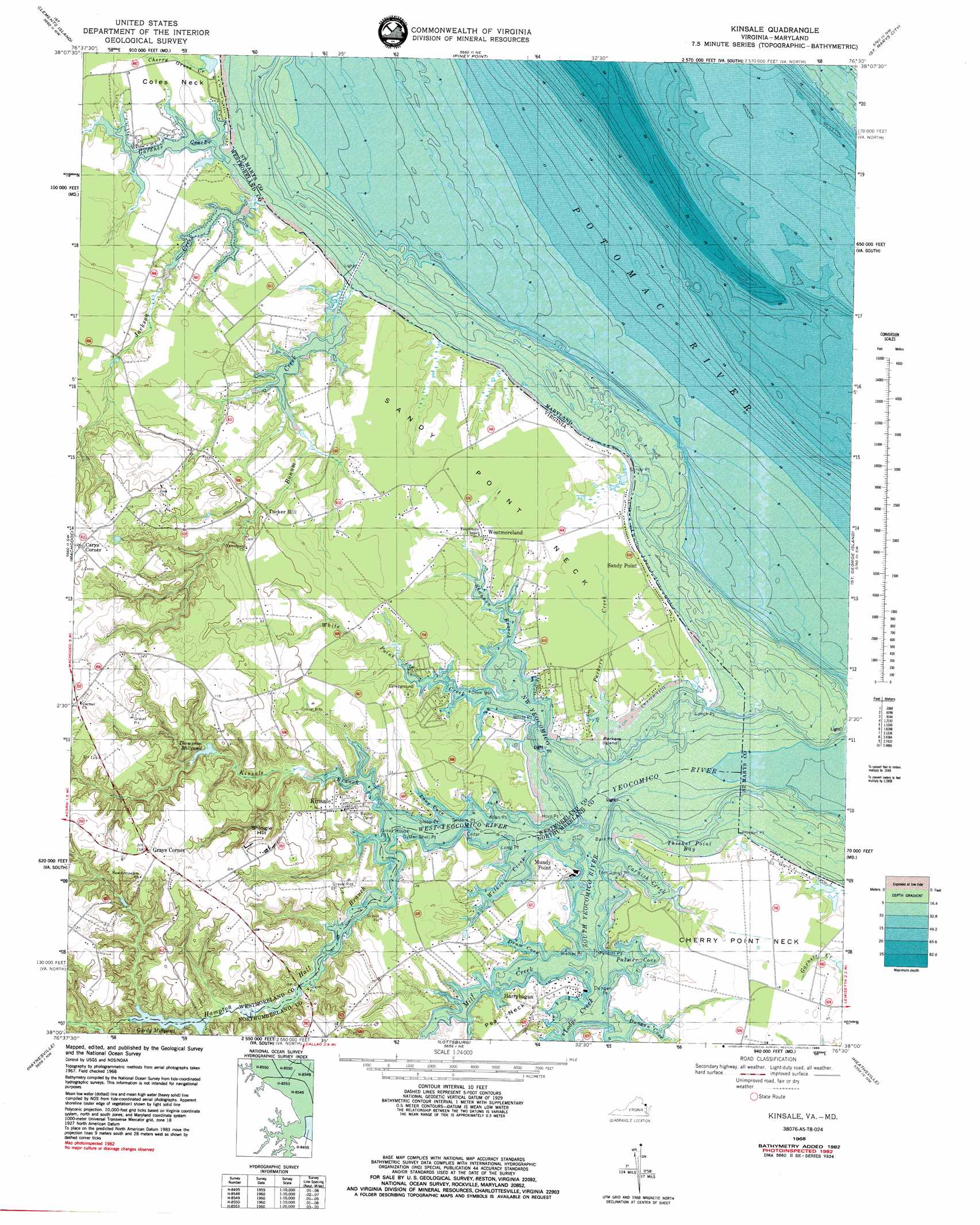
Kinsale Topo Map Virginia
To zoom in, hover over the map of Kinsale
USGS Topo Quad 38076a5 - 1:24,000 scale
| Topo Map Name: | Kinsale |
| USGS Topo Quad ID: | 38076a5 |
| Print Size: | ca. 21 1/4" wide x 27" high |
| Southeast Coordinates: | 38° N latitude / 76.5° W longitude |
| Map Center Coordinates: | 38.0625° N latitude / 76.5625° W longitude |
| U.S. States: | VA, MD |
| Filename: | o38076a5.jpg |
| Download Map JPG Image: | Kinsale topo map 1:24,000 scale |
| Map Type: | Topographic |
| Topo Series: | 7.5´ |
| Map Scale: | 1:24,000 |
| Source of Map Images: | United States Geological Survey (USGS) |
| Alternate Map Versions: |
Yeocomico River VA 1943, updated 1962 Download PDF Buy paper map Kinsale VA 1968, updated 1972 Download PDF Buy paper map Kinsale VA 1968, updated 1977 Download PDF Buy paper map Kinsale VA 1968, updated 1983 Download PDF Buy paper map Kinsale VA 1968, updated 1985 Download PDF Buy paper map Kinsale VA 2011 Download PDF Buy paper map Kinsale VA 2013 Download PDF Buy paper map Kinsale VA 2016 Download PDF Buy paper map |
1:24,000 Topo Quads surrounding Kinsale
Rock Point |
Leonardtown |
Hollywood |
Solomons Island |
Barren Island |
Stratford Hall |
Saint Clements Island |
Piney Point |
Saint Marys City |
Point No Point |
Montross |
Machodoc |
Kinsale |
Saint George Island |
Point Lookout |
Tappahannock |
Haynesville |
Lottsburg |
Heathsville |
Burgess |
Dunnsville |
Morattico |
Lively |
Lancaster |
Reedville |
> Back to 38076a1 at 1:100,000 scale
> Back to 38076a1 at 1:250,000 scale
> Back to U.S. Topo Maps home
Kinsale topo map: Gazetteer
Kinsale: Airports
Sanford Field elevation 2m 6′Shivok Airport elevation 7m 22′
Kinsale: Bays
Drum Cove elevation 0m 0′Dungan Cove elevation 0m 0′
Long Cove elevation 0m 0′
Palmer Cove elevation 0m 0′
Thicket Point Bay elevation 0m 0′
Kinsale: Bridges
Hampton Hall Bridge elevation 4m 13′Kinsale: Capes
Allen Point elevation 0m 0′Barn Point elevation 1m 3′
Cedar Point elevation 0m 0′
Cherry Point Neck elevation 3m 9′
Crow Bar elevation 0m 0′
Dungan Point elevation 2m 6′
Great House Point elevation 0m 0′
Harryhogan Point elevation 3m 9′
Horn Point elevation 1m 3′
Long Point elevation 1m 3′
Lynch Point elevation 0m 0′
Mondays Neck elevation 5m 16′
Mundy Point elevation 1m 3′
Oyster Shell Point elevation 1m 3′
Palmer Point elevation 0m 0′
Pea Neck elevation 7m 22′
Pecatone Neck elevation 4m 13′
Sandy Point elevation 1m 3′
Seldom Point elevation 0m 0′
Sloop Point elevation 1m 3′
Thicket Point elevation 0m 0′
Tom Jones Point elevation 1m 3′
Walker Point elevation 0m 0′
White Point elevation 1m 3′
Kinsale: Dams
Gardy Millpond Dam elevation 0m 0′Kinsale: Islands
Parkers Island elevation 0m 0′Kinsale: Lakes
Cherry Grove Pond elevation 1m 3′Kinsale: Populated Places
Carys Corner elevation 44m 144′Grays Corner elevation 34m 111′
Harryhogan elevation 3m 9′
Kinsale elevation 13m 42′
Morrisons Corner elevation 17m 55′
Sandy Point elevation 2m 6′
Shady Harbor Shores elevation 5m 16′
Tucker Hill elevation 13m 42′
Westmoreland elevation 3m 9′
Kinsale: Post Offices
Kinsale Post Office elevation 5m 16′Sandy Point Post Office elevation 3m 9′
Kinsale: Reservoirs
Gardy Millpond elevation 3m 9′Gardy Millpond elevation 0m 0′
Thompson Millpond elevation 4m 13′
Kinsale: Streams
Bonum Creek elevation 0m 0′Cherry Grove Creek elevation 1m 3′
Cornish Creek elevation 0m 0′
Gardner Creek elevation 5m 16′
Hampton Hall Branch elevation 0m 0′
Jackson Creek elevation 0m 0′
Kinsale Branch elevation 0m 0′
Lodge Creek elevation 0m 0′
Mill Creek elevation 0m 0′
Northwest Yeocomico River elevation 0m 0′
Parkers Creek elevation 0m 0′
Shannon Branch elevation 0m 0′
South Yeocomico River elevation 0m 0′
West Yeocomico River elevation 0m 0′
White Point Creek elevation 0m 0′
Wilkins Creek elevation 0m 0′
Yeocomico River elevation 0m 0′
Kinsale: Summits
Shingle Hill elevation 31m 101′Kinsale digital topo map on disk
Buy this Kinsale topo map showing relief, roads, GPS coordinates and other geographical features, as a high-resolution digital map file on DVD:
Atlantic Coast (NY, NJ, PA, DE, MD, VA, NC)
Buy digital topo maps: Atlantic Coast (NY, NJ, PA, DE, MD, VA, NC)
 map DVD")