Saint Clements Island Topo Map Virginia
To zoom in, hover over the map of Saint Clements Island
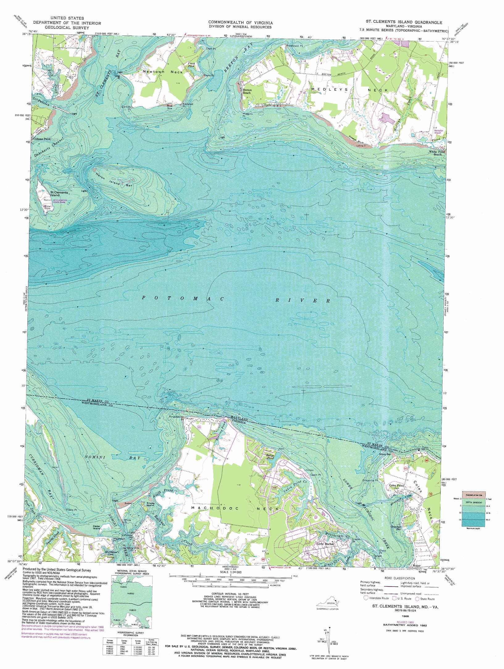
USGS Topo Quad 38076b6 - 1:24,000 scale
| Topo Map Name: | Saint Clements Island |
| USGS Topo Quad ID: | 38076b6 |
| Print Size: | ca. 21 1/4" wide x 27" high |
| Southeast Coordinates: | 38.125° N latitude / 76.625° W longitude |
| Map Center Coordinates: | 38.1875° N latitude / 76.6875° W longitude |
| U.S. States: | VA, MD |
| Filename: | o38076b6.jpg |
| Download Map JPG Image: | Saint Clements Island topo map 1:24,000 scale |
| Map Type: | Topographic |
| Topo Series: | 7.5´ |
| Map Scale: | 1:24,000 |
| Source of Map Images: | United States Geological Survey (USGS) |
| Alternate Map Versions: |
Blakiston Island MD 1953 Download PDF Buy paper map Blakiston Island MD 1953 Download PDF Buy paper map St Clements Island MD 1968, updated 1972 Download PDF Buy paper map St Clements Island MD 1968, updated 1976 Download PDF Buy paper map St. Clements Island MD 1968, updated 1983 Download PDF Buy paper map St. Clements Island MD 1968, updated 1993 Download PDF Buy paper map St. Clements Island MD 1968, updated 1997 Download PDF Buy paper map Saint Clements Island MD 2011 Download PDF Buy paper map Saint Clements Island MD 2014 Download PDF Buy paper map Saint Clements Island MD 2016 Download PDF Buy paper map |
1:24,000 Topo Quads surrounding Saint Clements Island
Popes Creek |
Charlotte Hall |
Mechanicsville |
Broomes Island |
Cove Point |
Colonial Beach North |
Rock Point |
Leonardtown |
Hollywood |
Solomons Island |
Colonial Beach South |
Stratford Hall |
Saint Clements Island |
Piney Point |
Saint Marys City |
Champlain |
Montross |
Machodoc |
Kinsale |
Saint George Island |
Mount Landing |
Tappahannock |
Haynesville |
Lottsburg |
Heathsville |
> Back to 38076a1 at 1:100,000 scale
> Back to 38076a1 at 1:250,000 scale
> Back to U.S. Topo Maps home
Saint Clements Island topo map: Gazetteer
Saint Clements Island: Airports
Hampton Airport elevation 5m 16′Nuns Oak Airport elevation 4m 13′
Saint Clements Island: Bars
Blue Sow elevation 3m 9′Heron Island Bar elevation 0m 0′
Stony Bar elevation 0m 0′
Saint Clements Island: Bays
Back Creek elevation 0m 0′Branson Cove elevation 1m 3′
Matthews Cove elevation 0m 0′
Nomini Bay elevation 0m 0′
Orchard Cove elevation 2m 6′
Raccoon Cove elevation 0m 0′
Saint Celments Bay elevation 0m 0′
Saint Clements Bay elevation 0m 0′
Saint Clements Island: Beaches
Port Sunlight Beach elevation 1m 3′Sandyland Beach elevation 0m 0′
Saint Clements Island: Capes
Beatley Point elevation 0m 0′Bedlam Neck elevation 3m 9′
Cabin Point elevation 3m 9′
Clem Point elevation 0m 0′
Coles Point elevation 3m 9′
Cornish Point elevation 3m 9′
Danger Point elevation 3m 9′
Elbow Point elevation 0m 0′
Glebe Point elevation 0m 0′
Grapevine Point elevation 0m 0′
Huggins Point elevation 2m 6′
Icehouse Point elevation 0m 0′
Kaywood Point elevation 3m 9′
Kingcopsico Point elevation 2m 6′
Linton Point elevation 3m 9′
Long Point elevation 1m 3′
Machodoc Neck elevation 3m 9′
Matthews Point elevation 2m 6′
Medleys Neck elevation 5m 16′
Newtown Neck elevation 4m 13′
Payne Point elevation 1m 3′
Protestant Point elevation 1m 3′
Shipping Point elevation 1m 3′
White Oak Point elevation 6m 19′
White Point elevation 1m 3′
Saint Clements Island: Channels
Dukeharts Channel elevation 0m 0′Saint Clements Island: Cliffs
Poseys Bluff elevation 3m 9′Saint Clements Island: Islands
Cedar Island elevation 3m 9′Heron Island (historical) elevation 0m 0′
Saint Clements Island elevation 3m 9′
Snake Island elevation 0m 0′
Trent Island elevation 0m 0′
Saint Clements Island: Lakes
Bettys Pond elevation 3m 9′Fresh Pond elevation 5m 16′
Herring Pond elevation 3m 9′
Saint Clements Island: Pillars
Stone Cross elevation 3m 9′Saint Clements Island: Populated Places
Breton Beach elevation 2m 6′Coles Point elevation 3m 9′
Meter elevation 3m 9′
Sandyland Beach elevation 4m 13′
Saint Clements Island: Post Offices
Coles Point Post Office elevation 3m 9′Saint Clements Island: Streams
Aimes Creek elevation 0m 0′Buckner Creek elevation 0m 0′
Cabin Point Creek elevation 3m 9′
Flood Creek elevation 2m 6′
Glebe Creek elevation 0m 0′
Lower Machodoc Creek elevation 0m 0′
Medleys Creek elevation 2m 6′
Nomini Creek elevation 0m 0′
North Prong Buckner Creek elevation 0m 0′
Poor Jack Creek elevation 0m 0′
Saint Patrick Creek elevation 0m 0′
Smarts Creek elevation 0m 0′
Weatherall Creek elevation 0m 0′
Saint Clements Island: Swamps
Grannys Bar elevation 3m 9′Saint Clements Island digital topo map on disk
Buy this Saint Clements Island topo map showing relief, roads, GPS coordinates and other geographical features, as a high-resolution digital map file on DVD:
Atlantic Coast (NY, NJ, PA, DE, MD, VA, NC)
Buy digital topo maps: Atlantic Coast (NY, NJ, PA, DE, MD, VA, NC)
 map DVD")