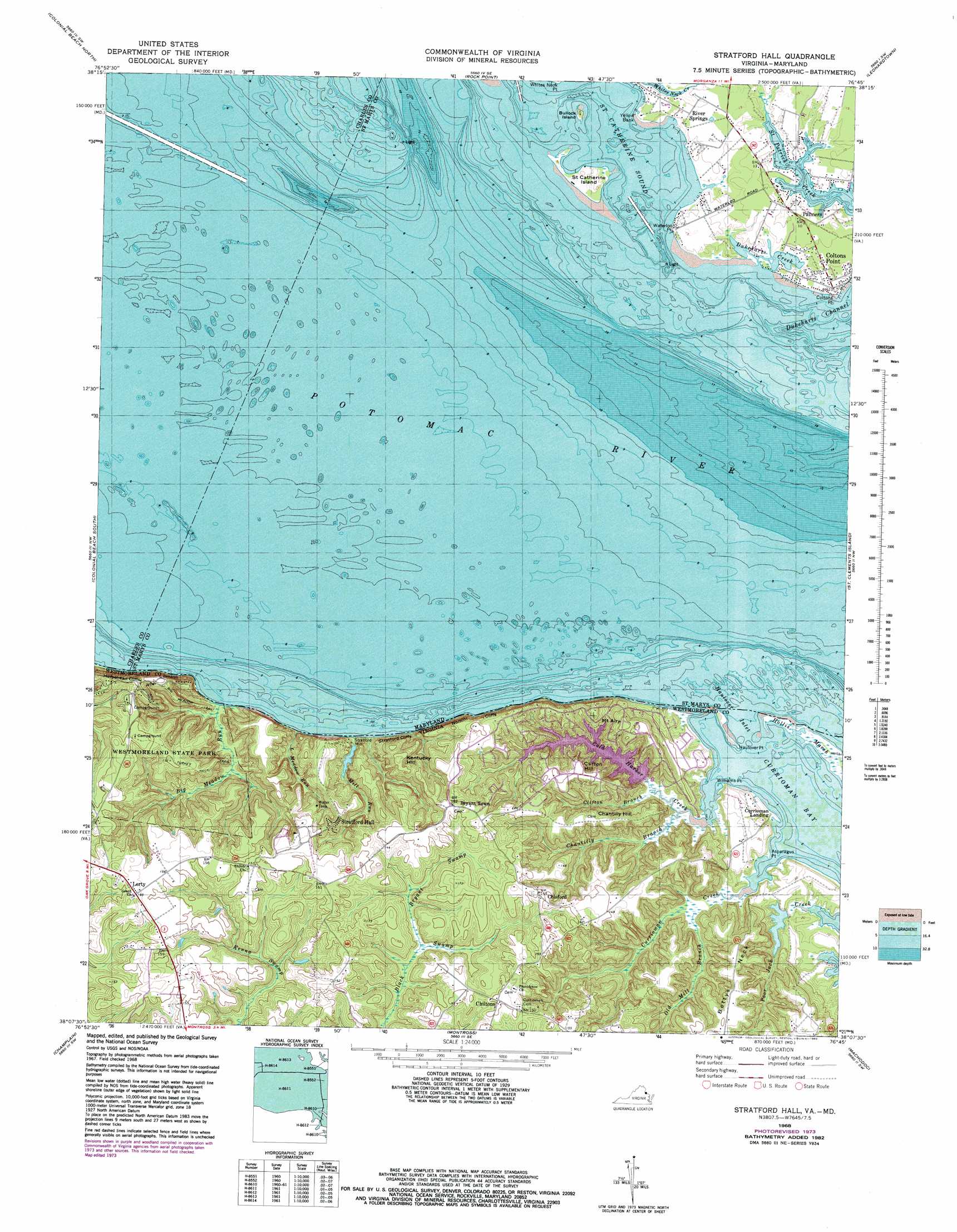
Stratford Hall Topo Map Virginia
To zoom in, hover over the map of Stratford Hall
USGS Topo Quad 38076b7 - 1:24,000 scale
| Topo Map Name: | Stratford Hall |
| USGS Topo Quad ID: | 38076b7 |
| Print Size: | ca. 21 1/4" wide x 27" high |
| Southeast Coordinates: | 38.125° N latitude / 76.75° W longitude |
| Map Center Coordinates: | 38.1875° N latitude / 76.8125° W longitude |
| U.S. States: | VA, MD |
| Filename: | o38076b7.jpg |
| Download Map JPG Image: | Stratford Hall topo map 1:24,000 scale |
| Map Type: | Topographic |
| Topo Series: | 7.5´ |
| Map Scale: | 1:24,000 |
| Source of Map Images: | United States Geological Survey (USGS) |
| Alternate Map Versions: |
Stratford VA 1946, updated 1952 Download PDF Buy paper map Stratford Hall VA 1968, updated 1974 Download PDF Buy paper map Stratford Hall VA 1968, updated 1983 Download PDF Buy paper map Stratford Hall VA 1981, updated 1985 Download PDF Buy paper map Stratford Hall VA 1981, updated 1986 Download PDF Buy paper map Stratford Hall VA 2011 Download PDF Buy paper map Stratford Hall VA 2013 Download PDF Buy paper map Stratford Hall VA 2016 Download PDF Buy paper map |
1:24,000 Topo Quads surrounding Stratford Hall
Mathias Point |
Popes Creek |
Charlotte Hall |
Mechanicsville |
Broomes Island |
Dahlgren |
Colonial Beach North |
Rock Point |
Leonardtown |
Hollywood |
Rollins Fork |
Colonial Beach South |
Stratford Hall |
Saint Clements Island |
Piney Point |
Loretto |
Champlain |
Montross |
Machodoc |
Kinsale |
Cauthornville |
Mount Landing |
Tappahannock |
Haynesville |
Lottsburg |
> Back to 38076a1 at 1:100,000 scale
> Back to 38076a1 at 1:250,000 scale
> Back to U.S. Topo Maps home
Stratford Hall topo map: Gazetteer
Stratford Hall: Bars
Waterloo Point Bar elevation 0m 0′Yellow Bank Point Bar elevation 8m 26′
Stratford Hall: Bays
Currioman Bay elevation -1m -4′Dukeharts Creek elevation 1m 3′
Haulover Inlet elevation -1m -4′
Saint Catherine Sound elevation 0m 0′
Stratford Hall: Capes
Asparagus Point elevation 1m 3′Bettys Neck elevation 41m 134′
Coltons Point elevation 3m 9′
Haulover Point elevation -1m -4′
Waterloo Point elevation 3m 9′
Williams Point elevation 0m 0′
Yellow Bank elevation 5m 16′
Stratford Hall: Cliffs
Horsehead Cliffs elevation 36m 118′Nomini Cliffs elevation 11m 36′
Stratford Cliffs elevation 9m 29′
Stratford Hall: Dams
Lake Independence Dam elevation 13m 42′Stratford Hall: Guts
Haulover Inlet elevation -1m -4′Stratford Hall: Islands
Bullock Island elevation 4m 13′Saint Catherine Island elevation 2m 6′
Stratford Hall: Parks
Saint Clements Island Historic District elevation 3m 9′Westmoreland State Park elevation 43m 141′
Stratford Hall: Populated Places
Bryant Town elevation 50m 164′Chiltons elevation 46m 150′
Chisford elevation 44m 144′
Coltons Point elevation 4m 13′
Currioman Landing elevation 1m 3′
Lerty elevation 52m 170′
Palmers elevation 3m 9′
River Springs elevation 4m 13′
Stratford Hall elevation 45m 147′
Stratford Mill elevation 6m 19′
Waterloo elevation 3m 9′
Stratford Hall: Post Offices
Coltons Point Post Office elevation 4m 13′Stratford Hall: Reservoirs
Lake Independence elevation 13m 42′Stratford Millpond elevation 7m 22′
Stratford Hall: Streams
Big Meadow Run elevation 0m 0′Bryant Swamp elevation 26m 85′
Chantilly Branch elevation 1m 3′
Clifton Branch elevation 2m 6′
Cold Harbor Creek elevation -1m -4′
Currioman Creek elevation -1m -4′
Kentucky Run elevation 2m 6′
Little Meadow Run elevation 2m 6′
Mill Run elevation 0m 0′
Old Mill Branch elevation 2m 6′
Stratford Hall: Summits
Chantilly Hill elevation 44m 144′Clifton Hill elevation 47m 154′
Kentucky Hill elevation 50m 164′
Mount Airy elevation 47m 154′
Stratford Hall: Swamps
Hollis Marsh elevation 0m 0′Stratford Hall: Trails
Big Meadow Trail elevation 36m 118′Turkey Neck Trail elevation 37m 121′
Stratford Hall digital topo map on disk
Buy this Stratford Hall topo map showing relief, roads, GPS coordinates and other geographical features, as a high-resolution digital map file on DVD:
Atlantic Coast (NY, NJ, PA, DE, MD, VA, NC)
Buy digital topo maps: Atlantic Coast (NY, NJ, PA, DE, MD, VA, NC)
 map DVD")