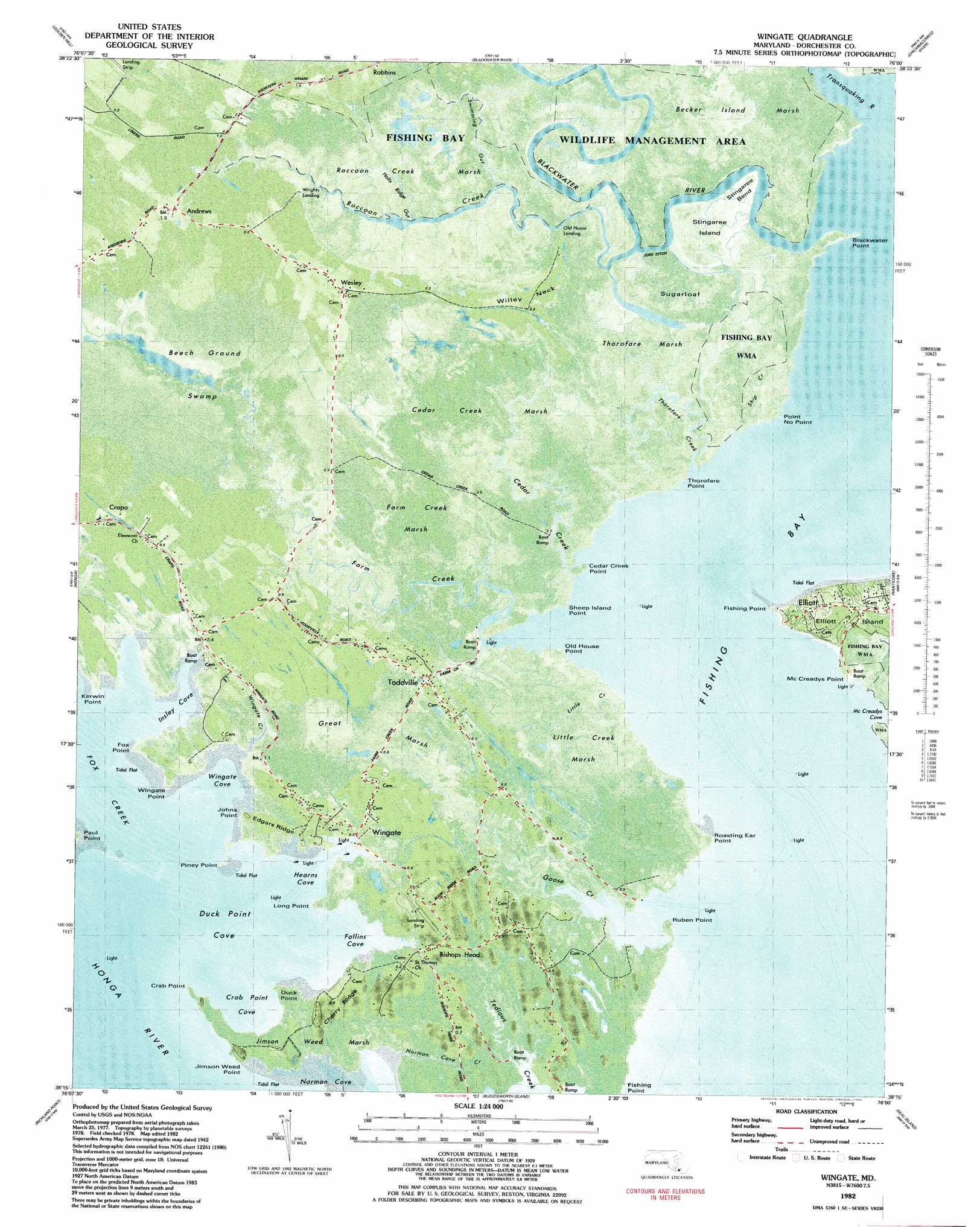
Wingate Topo Map Maryland
To zoom in, hover over the map of Wingate
USGS Topo Quad 38076c1 - 1:24,000 scale
| Topo Map Name: | Wingate |
| USGS Topo Quad ID: | 38076c1 |
| Print Size: | ca. 21 1/4" wide x 27" high |
| Southeast Coordinates: | 38.25° N latitude / 76° W longitude |
| Map Center Coordinates: | 38.3125° N latitude / 76.0625° W longitude |
| U.S. State: | MD |
| Filename: | p38076c1.jpg |
| Download Map JPG Image: | Wingate topo map 1:24,000 scale |
| Map Type: | Orthophoto |
| Topo Series: | 7.5´ |
| Map Scale: | 1:24,000 |
| Source of Map Images: | United States Geological Survey (USGS) |
| Alternate Map Versions: |
Wingate MD 1942, updated 1962 Download PDF Buy paper map Wingate MD 1942, updated 1962 Download PDF Buy paper map Wingate MD 1982, updated 1983 Download PDF Buy paper map Wingate MD 1982, updated 1983 Download PDF Buy paper map Wingate MD 2011 Download PDF Buy paper map Wingate MD 2014 Download PDF Buy paper map Wingate MD 2016 Download PDF Buy paper map |
1:24,000 Topo Quads surrounding Wingate
Hudson |
Church Creek |
Cambridge |
East New Market |
Rhodesdale |
Taylors Island |
Golden Hill |
Blackwater River |
Chicamacomico River |
Mardela Springs |
Barren Island |
Honga |
Wingate |
Nanticoke |
Wetipquin |
Point No Point |
Richland Point |
Bloodsworth Island |
Deal Island |
Monie |
Point Lookout |
East Of Point Lookout |
Kedges Straits |
Terrapin Sand Point |
Marion |
> Back to 38076a1 at 1:100,000 scale
> Back to 38076a1 at 1:250,000 scale
> Back to U.S. Topo Maps home
Wingate topo map: Gazetteer
Wingate: Bays
Crab Point Cove elevation 0m 0′Duck Point Cove elevation 0m 0′
Falling Cove elevation 0m 0′
Fishing Bay elevation 0m 0′
Fox Creek elevation 0m 0′
Hearns Cove elevation 0m 0′
Insley Cove elevation 0m 0′
McCreadys Cove elevation 0m 0′
Negro Cove elevation 0m 0′
Norman Cove elevation 0m 0′
Wingate Cove elevation 0m 0′
Wingate Creek elevation 1m 3′
Wingate: Bends
Stingaree Bend elevation 1m 3′Wingate: Canals
Jobs Ditch elevation 0m 0′Wingate: Capes
Blackwater Point elevation 0m 0′Cedar Creek Point elevation 0m 0′
Crab Point elevation 0m 0′
Duck Point elevation 0m 0′
Fishing Point elevation 1m 3′
Fox Point elevation 1m 3′
Harts Point elevation 0m 0′
Jimson Weed Point elevation 0m 0′
Johns Point elevation 0m 0′
Kirwan Point elevation 0m 0′
Long Point elevation -1m -4′
McCreadys Point elevation 1m 3′
Old House Point elevation 1m 3′
Paul Point elevation 0m 0′
Piney Point elevation 0m 0′
Point No Point elevation 0m 0′
Roasting Ear Point elevation 1m 3′
Ruben Point elevation 1m 3′
Sheep Island Point elevation 0m 0′
Smith Point elevation 0m 0′
Thorofare Point elevation 0m 0′
Willey Neck elevation 1m 3′
Wingate Point elevation 2m 6′
Wingate: Channels
Stingaree Creek elevation 1m 3′Wingate: Islands
Elliott Island elevation 1m 3′Sheep Island elevation 0m 0′
Snake Island elevation 1m 3′
Stingaree Island elevation 1m 3′
Sugarloaf elevation 1m 3′
Wingate: Populated Places
Andrews elevation 1m 3′Bishops Head elevation 1m 3′
Toddville elevation 1m 3′
Wesley elevation 1m 3′
Wingate elevation 1m 3′
Wingate: Post Offices
Bishops Head Post Office elevation 1m 3′Elliott Post Office elevation 0m 0′
Toddville Post Office elevation 0m 0′
Wingate Post Office elevation 1m 3′
Wingate Post Office (historical) elevation 1m 3′
Wingate: Ridges
Cherry Ridge elevation 0m 0′Edgars Ridge elevation 1m 3′
Wingate: Streams
Blackwater River elevation 0m 0′Bridge Creek elevation 1m 3′
Cedar Creek elevation 0m 0′
Farm Creek elevation 0m 0′
Goose Creek elevation 0m 0′
Hearns Creek elevation 0m 0′
Holts Ridge Gut elevation 0m 0′
Little Creek elevation 0m 0′
McCreadys Creek elevation 0m 0′
Norman Cove Creek elevation 0m 0′
Raccoon Creek elevation 1m 3′
Ship Creek elevation 1m 3′
Swimming Creek elevation 1m 3′
Thorofare Creek elevation 0m 0′
Transquaking River elevation 0m 0′
Wingate: Swamps
Beech Ground Swamp elevation 1m 3′Beech Ground Swamp elevation 0m 0′
Cedar Creek Marsh elevation 1m 3′
Farm Creek Marsh elevation 0m 0′
Great Marsh elevation 1m 3′
Jimson Weed Marsh elevation 1m 3′
Little Creek Marsh elevation 1m 3′
Raccoon Creek Marsh elevation 1m 3′
Thorofare Marsh elevation 1m 3′
Wingate digital topo map on disk
Buy this Wingate topo map showing relief, roads, GPS coordinates and other geographical features, as a high-resolution digital map file on DVD:
Atlantic Coast (NY, NJ, PA, DE, MD, VA, NC)
Buy digital topo maps: Atlantic Coast (NY, NJ, PA, DE, MD, VA, NC)
 map DVD")