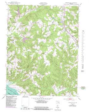
Charlotte Hall Topo Map Maryland
To zoom in, hover over the map of Charlotte Hall
USGS Topo Quad 38076d7 - 1:24,000 scale
| Topo Map Name: | Charlotte Hall |
| USGS Topo Quad ID: | 38076d7 |
| Print Size: | ca. 21 1/4" wide x 27" high |
| Southeast Coordinates: | 38.375° N latitude / 76.75° W longitude |
| Map Center Coordinates: | 38.4375° N latitude / 76.8125° W longitude |
| U.S. State: | MD |
| Filename: | o38076d7.jpg |
| Download Map JPG Image: | Charlotte Hall topo map 1:24,000 scale |
| Map Type: | Topographic |
| Topo Series: | 7.5´ |
| Map Scale: | 1:24,000 |
| Source of Map Images: | United States Geological Survey (USGS) |
| Alternate Map Versions: |
Charlotte Hall MD 1953, updated 1954 Download PDF Buy paper map Charlotte Hall MD 1953, updated 1954 Download PDF Buy paper map Charlotte Hall MD 1953, updated 1965 Download PDF Buy paper map Charlotte Hall MD 1953, updated 1977 Download PDF Buy paper map Charlotte Hall MD 1953, updated 1983 Download PDF Buy paper map Charlotte Hall MD 2011 Download PDF Buy paper map Charlotte Hall MD 2014 Download PDF Buy paper map Charlotte Hall MD 2016 Download PDF Buy paper map |
1:24,000 Topo Quads surrounding Charlotte Hall
> Back to 38076a1 at 1:100,000 scale
> Back to 38076a1 at 1:250,000 scale
> Back to U.S. Topo Maps home
Charlotte Hall topo map: Gazetteer
Charlotte Hall: Bays
Budds Creek elevation 47m 154′Charlotte Hall: Capes
Luckton Point elevation 4m 13′Charlotte Hall: Dams
Trinity Church Dam elevation 15m 49′Wheately Dam elevation 37m 121′
Charlotte Hall: Parks
Charlotte Hall Historic District elevation 53m 173′Fifth District Park elevation 48m 157′
Gilbert Run Regional Park elevation 22m 72′
Charlotte Hall: Populated Places
Amberleigh Farms elevation 57m 187′Arborview elevation 52m 170′
Beverly Estates elevation 46m 150′
Birch Hanger elevation 50m 164′
Budds Creek elevation 48m 157′
Charlotte Hall elevation 51m 167′
Chickasaw Run elevation 49m 160′
Coffee Hill elevation 47m 154′
Country Lakes elevation 49m 160′
Dubois elevation 55m 180′
Dubois Park elevation 55m 180′
Locke Hill Estates elevation 52m 170′
Melody Acres elevation 45m 147′
Newmarket elevation 55m 180′
Norwood elevation 49m 160′
Oaks elevation 52m 170′
Old Sycamore Estates elevation 51m 167′
Redgate elevation 52m 170′
Ryceville elevation 52m 170′
Stilltown (historical) elevation 55m 180′
The Plains elevation 51m 167′
Thompson Corner elevation 54m 177′
Trenton Place elevation 50m 164′
Wicomico Shores elevation 45m 147′
Willerle Manor elevation 38m 124′
Wood-N-Dale Estates elevation 41m 134′
Charlotte Hall: Post Offices
Charlotte Hall Post Office elevation 52m 170′Mechanicsville Post Office elevation 50m 164′
Charlotte Hall: Reservoirs
Gilbert Run Lake elevation 33m 108′Gilbert Run Reservoir Site Number 1 elevation 15m 49′
Smoots Pond elevation 47m 154′
Trinity Lake elevation 25m 82′
Wheatley Reservoir elevation 37m 121′
Charlotte Hall: Streams
Budds Creek elevation 1m 3′Burroughs Run elevation 1m 3′
Denton Run elevation 15m 49′
Forrest Hall Branch elevation 11m 36′
Gilbert Creek elevation 21m 68′
Hayden Run elevation 3m 9′
Jenkins Run elevation 4m 13′
Lacy Run elevation 16m 52′
Luckton Run elevation -1m -4′
Oaks Run elevation 51m 167′
Reaves Creek elevation 21m 68′
Trinity Church Run elevation 12m 39′
Wheatley Run elevation 19m 62′
Charlotte Hall digital topo map on disk
Buy this Charlotte Hall topo map showing relief, roads, GPS coordinates and other geographical features, as a high-resolution digital map file on DVD:
Atlantic Coast (NY, NJ, PA, DE, MD, VA, NC)
Buy digital topo maps: Atlantic Coast (NY, NJ, PA, DE, MD, VA, NC)


