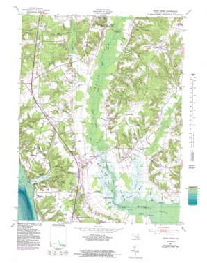
Popes Creek Topo Map Maryland
To zoom in, hover over the map of Popes Creek
USGS Topo Quad 38076d8 - 1:24,000 scale
| Topo Map Name: | Popes Creek |
| USGS Topo Quad ID: | 38076d8 |
| Print Size: | ca. 21 1/4" wide x 27" high |
| Southeast Coordinates: | 38.375° N latitude / 76.875° W longitude |
| Map Center Coordinates: | 38.4375° N latitude / 76.9375° W longitude |
| U.S. State: | MD |
| Filename: | o38076d8.jpg |
| Download Map JPG Image: | Popes Creek topo map 1:24,000 scale |
| Map Type: | Topographic |
| Topo Series: | 7.5´ |
| Map Scale: | 1:24,000 |
| Source of Map Images: | United States Geological Survey (USGS) |
| Alternate Map Versions: |
Popes Creek MD 1953, updated 1954 Download PDF Buy paper map Popes Creek MD 1953, updated 1954 Download PDF Buy paper map Popes Creek MD 1953, updated 1969 Download PDF Buy paper map Popes Creek MD 1953, updated 1978 Download PDF Buy paper map Popes Creek MD 1953, updated 1983 Download PDF Buy paper map Popes Creek MD 2011 Download PDF Buy paper map Popes Creek MD 2014 Download PDF Buy paper map Popes Creek MD 2016 Download PDF Buy paper map |
1:24,000 Topo Quads surrounding Popes Creek
> Back to 38076a1 at 1:100,000 scale
> Back to 38076a1 at 1:250,000 scale
> Back to U.S. Topo Maps home
Popes Creek topo map: Gazetteer
Popes Creek: Bays
Allens Fresh Run elevation 0m 0′Forest Cove elevation 0m 0′
Mud Cove elevation 0m 0′
Popes Creek: Bends
Foggy Bottoms elevation 4m 13′Popes Creek: Bridges
Dentsville Bridge elevation 14m 45′Popes Creek Bridge elevation 1m 3′
Stones Bridge elevation 15m 49′
Popes Creek: Capes
Carpenter Point elevation 3m 9′Cooksey Point elevation 0m 0′
McReynolds Point elevation 4m 13′
Westwood Point elevation 3m 9′
Woodland Point elevation 0m 0′
Popes Creek: Guts
Cramer Gut elevation 0m 0′Foggy Bottoms Gut elevation 1m 3′
Hickory Gut elevation 4m 13′
Saint Clair Gut elevation 1m 3′
Steinhauser Gut elevation -2m -7′
Tears Gut elevation 3m 9′
Popes Creek: Islands
Cooksey Island elevation 0m 0′Popes Creek: Parks
Zekiah Swamp Natural Environment Area elevation 1m 3′Popes Creek: Populated Places
Allens Fresh elevation 4m 13′Amys Acres elevation 48m 157′
Bel Alton elevation 51m 167′
Bel Alton Estates elevation 48m 157′
Birkwood Estates elevation 46m 150′
Chapel Point Woods elevation 50m 164′
Cooksey Knolls elevation 47m 154′
Deer Park elevation 47m 154′
Dentsville elevation 57m 187′
Faulkner elevation 48m 157′
Gilbert Acres elevation 50m 164′
Hard Corner elevation 35m 114′
Huckleberry elevation 35m 114′
Huntley Estates elevation 47m 154′
Husick Estates elevation 47m 154′
Knollcrest elevation 47m 154′
Lothair Station elevation 41m 134′
Newburg elevation 39m 127′
Newport elevation 3m 9′
Popes Creek elevation 1m 3′
Preference Estates elevation 42m 137′
Rogers Mill elevation 15m 49′
Rolling Hills elevation 48m 157′
Spring Hill (historical) elevation 51m 167′
Thomas Manor elevation 50m 164′
Wicomico elevation 44m 144′
Wicomico Ridge elevation 36m 118′
Popes Creek: Post Offices
Bel Alton Post Office elevation 53m 173′Faulkner Post Office elevation 48m 157′
Newburg Post Office elevation 40m 131′
Popes Creek: Streams
Bowling Creek elevation 2m 6′Bowling Gut elevation 3m 9′
Bowman Creek elevation 8m 26′
Bunker Hill Branch elevation 1m 3′
Clark Run elevation 5m 16′
Colby Run elevation 0m 0′
Cooksey Run elevation 10m 32′
Drinks Run elevation 2m 6′
Ellenboro Hill Run elevation 3m 9′
Ford Run elevation 6m 19′
Gilbert Swamp Run elevation 2m 6′
Glasva Branch elevation 1m 3′
Hells Bottom Run elevation 10m 32′
Herbert Run elevation 3m 9′
Hodister Run elevation 1m 3′
Huckleberry Branch elevation 9m 29′
Ivory Run elevation 10m 32′
James Run elevation 10m 32′
Lancaster Run elevation 3m 9′
Lloyd Drain elevation 0m 0′
Maddox Branch elevation 16m 52′
Mud Creek elevation 2m 6′
Murphy Run elevation 4m 13′
Newport Branch elevation 15m 49′
Newport Marsh Run elevation 1m 3′
Newport Run elevation 0m 0′
Oden Run elevation 5m 16′
Old Mill Branch elevation 3m 9′
Peach Run elevation 4m 13′
Popes Creek elevation 0m 0′
Posey Creek elevation 0m 0′
Rice Creek elevation 7m 22′
Rogers Mill Branch elevation 11m 36′
Ross Branch elevation 7m 22′
Saint Stephen Run elevation 15m 49′
Scar Branch elevation 4m 13′
Spring Hill Branch elevation 20m 65′
Stoner Creek elevation 12m 39′
Willmer Creek elevation 4m 13′
Zekiah Swamp Run elevation 2m 6′
Popes Creek: Summits
Bunker Hill elevation 38m 124′Ellenboro Hill elevation 36m 118′
Ravens Crest elevation 31m 101′
Popes Creek: Swamps
Fresh Marsh elevation 3m 9′Newport Marsh elevation 3m 9′
Popes Creek digital topo map on disk
Buy this Popes Creek topo map showing relief, roads, GPS coordinates and other geographical features, as a high-resolution digital map file on DVD:
Atlantic Coast (NY, NJ, PA, DE, MD, VA, NC)
Buy digital topo maps: Atlantic Coast (NY, NJ, PA, DE, MD, VA, NC)


