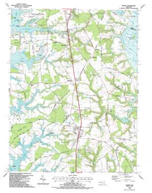
Trappe Topo Map Maryland
To zoom in, hover over the map of Trappe
USGS Topo Quad 38076f1 - 1:24,000 scale
| Topo Map Name: | Trappe |
| USGS Topo Quad ID: | 38076f1 |
| Print Size: | ca. 21 1/4" wide x 27" high |
| Southeast Coordinates: | 38.625° N latitude / 76° W longitude |
| Map Center Coordinates: | 38.6875° N latitude / 76.0625° W longitude |
| U.S. State: | MD |
| Filename: | o38076f1.jpg |
| Download Map JPG Image: | Trappe topo map 1:24,000 scale |
| Map Type: | Topographic |
| Topo Series: | 7.5´ |
| Map Scale: | 1:24,000 |
| Source of Map Images: | United States Geological Survey (USGS) |
| Alternate Map Versions: |
Trappe MD 1942, updated 1962 Download PDF Buy paper map Trappe MD 1942, updated 1973 Download PDF Buy paper map Trappe MD 1942, updated 1976 Download PDF Buy paper map Trappe MD 1988, updated 1988 Download PDF Buy paper map Trappe MD 2011 Download PDF Buy paper map Trappe MD 2014 Download PDF Buy paper map Trappe MD 2016 Download PDF Buy paper map |
1:24,000 Topo Quads surrounding Trappe
> Back to 38076e1 at 1:100,000 scale
> Back to 38076a1 at 1:250,000 scale
> Back to U.S. Topo Maps home
Trappe topo map: Gazetteer
Trappe: Bays
Atwells Cove elevation 0m 0′Connolly Cove elevation 0m 0′
Haskins Cove elevation 0m 0′
Le Gates Cove elevation 8m 26′
Leonard Cove elevation 2m 6′
Lowry Cove elevation 2m 6′
Pirates Cove elevation 0m 0′
Prices Cove elevation 0m 0′
Sawmill Cove elevation 0m 0′
Trappe: Capes
Baileys Neck elevation 3m 9′Camden Point elevation 1m 3′
Connolly Point elevation 2m 6′
Eastwood Point elevation 1m 3′
Edmundson Neck elevation 6m 19′
Frazier Point elevation 0m 0′
Graves Point elevation 1m 3′
Grubin Neck elevation 4m 13′
Island Neck elevation 3m 9′
Martin Point elevation 0m 0′
Neck Point elevation 1m 3′
Peachorchard Cove elevation 0m 0′
Rattlesnake Point elevation 3m 9′
Trappe: Dams
Easton Primary Sewage Lagoon Dam elevation 11m 36′Easton Secondary Sewage Lagoon Dam elevation 11m 36′
Talbot Country Club Pond Dam elevation 2m 6′
Trappe: Forests
Seth State Forest elevation 19m 62′Trappe: Parks
Choptank Wetlands Preserve elevation 1m 3′Otwell Woodland Preserve elevation 3m 9′
Trappe Park elevation 17m 55′
Trappe: Populated Places
Barber elevation 14m 45′Beechwood elevation 7m 22′
Bristolwood elevation 8m 26′
Canterbury elevation 4m 13′
Cedar Point elevation 4m 13′
Cooks Hope elevation 6m 19′
Country Club Estates elevation 2m 6′
Ellenborough elevation 4m 13′
Frankford elevation 10m 32′
Gilnock Hall elevation 7m 22′
Hambleton elevation 15m 49′
Hampton elevation 3m 9′
Holly Oaks elevation 19m 62′
Ivytown elevation 20m 65′
La Trappe Heights elevation 17m 55′
Llandaff elevation 7m 22′
Locust Grove elevation 4m 13′
Manadier elevation 18m 59′
Oaklands elevation 5m 16′
Patrick Plains elevation 4m 13′
Peach Blossom Heights elevation 12m 39′
Peach Orchard elevation 3m 9′
Peachblossom elevation 6m 19′
Sailors Retreat elevation 4m 13′
South Beechwood elevation 12m 39′
Springfield elevation 6m 19′
Trappe elevation 16m 52′
Trappe Landing elevation 1m 3′
Waverly Island Estates elevation 3m 9′
Williamsburg elevation 15m 49′
Trappe: Post Offices
Trappe Post Office elevation 16m 52′Trappe: Streams
Barker Creek elevation 2m 6′Crosiadore Creek elevation 1m 3′
Deep Branch elevation 8m 26′
Peachblossom Creek elevation 0m 0′
Trappe digital topo map on disk
Buy this Trappe topo map showing relief, roads, GPS coordinates and other geographical features, as a high-resolution digital map file on DVD:
Atlantic Coast (NY, NJ, PA, DE, MD, VA, NC)
Buy digital topo maps: Atlantic Coast (NY, NJ, PA, DE, MD, VA, NC)


