Lower Marlboro Topo Map Maryland
To zoom in, hover over the map of Lower Marlboro
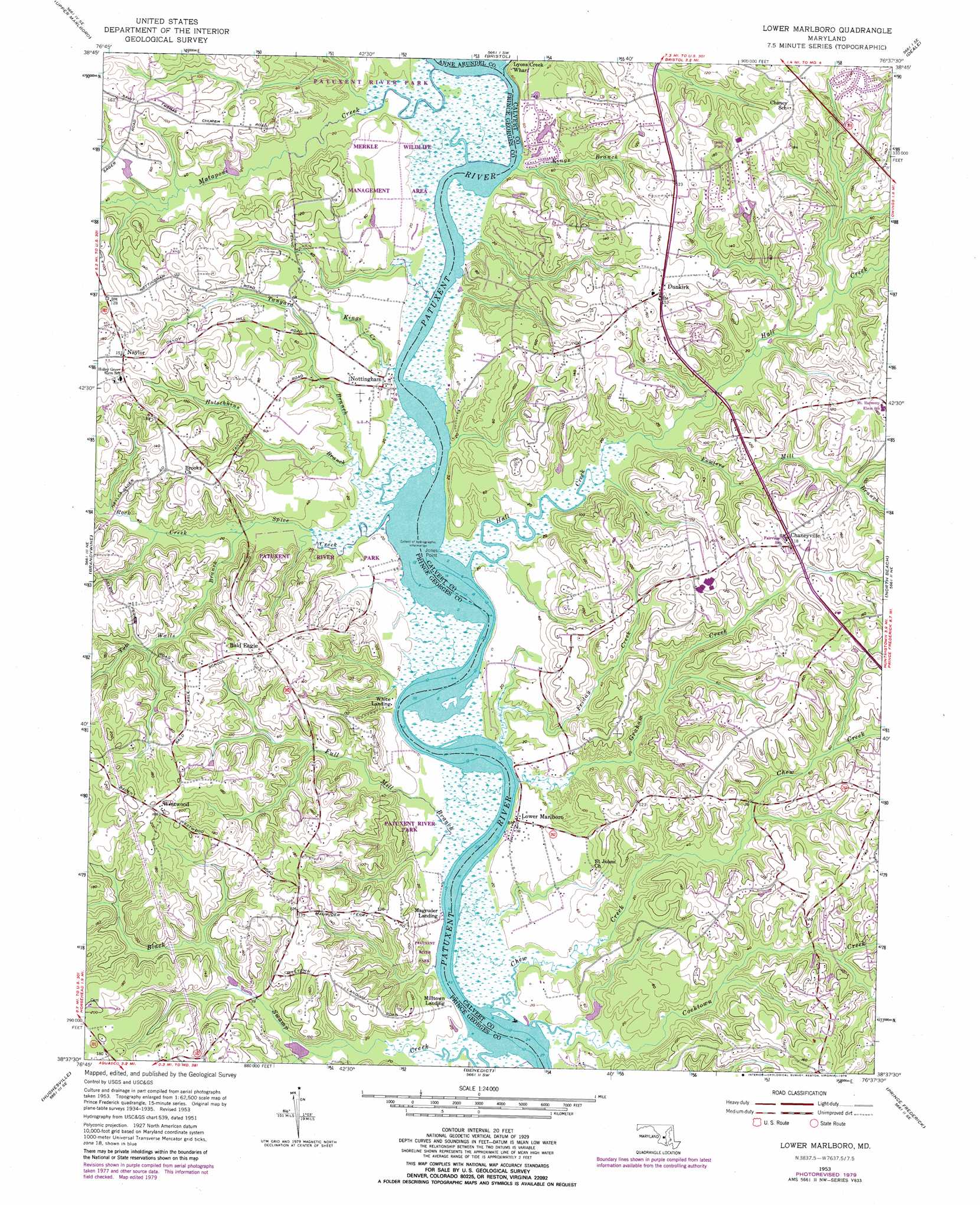
USGS Topo Quad 38076f6 - 1:24,000 scale
| Topo Map Name: | Lower Marlboro |
| USGS Topo Quad ID: | 38076f6 |
| Print Size: | ca. 21 1/4" wide x 27" high |
| Southeast Coordinates: | 38.625° N latitude / 76.625° W longitude |
| Map Center Coordinates: | 38.6875° N latitude / 76.6875° W longitude |
| U.S. State: | MD |
| Filename: | o38076f6.jpg |
| Download Map JPG Image: | Lower Marlboro topo map 1:24,000 scale |
| Map Type: | Topographic |
| Topo Series: | 7.5´ |
| Map Scale: | 1:24,000 |
| Source of Map Images: | United States Geological Survey (USGS) |
| Alternate Map Versions: |
Lower Marlboro MD 1953, updated 1956 Download PDF Buy paper map Lower Marlboro MD 1953, updated 1966 Download PDF Buy paper map Lower Marlboro MD 1953, updated 1971 Download PDF Buy paper map Lower Marlboro MD 1953, updated 1976 Download PDF Buy paper map Lower Marlboro MD 1953, updated 1979 Download PDF Buy paper map Lower Marlboro MD 1953, updated 1979 Download PDF Buy paper map Lower Marlboro MD 2011 Download PDF Buy paper map Lower Marlboro MD 2014 Download PDF Buy paper map Lower Marlboro MD 2016 Download PDF Buy paper map |
1:24,000 Topo Quads surrounding Lower Marlboro
Washington East |
Lanham |
Bowie |
South River |
Annapolis |
Anacostia |
Upper Marlboro |
Bristol |
Deale |
|
Piscataway |
Brandywine |
Lower Marlboro |
North Beach |
|
La Plata |
Hughesville |
Benedict |
Prince Frederick |
|
Popes Creek |
Charlotte Hall |
Mechanicsville |
Broomes Island |
Cove Point |
> Back to 38076e1 at 1:100,000 scale
> Back to 38076a1 at 1:250,000 scale
> Back to U.S. Topo Maps home
Lower Marlboro topo map: Gazetteer
Lower Marlboro: Airports
Lower Marlboro Airport elevation 10m 32′Lower Marlboro: Capes
Jones Point elevation 1m 3′Short Point elevation 0m 0′
Sneaking Point elevation 0m 0′
Lower Marlboro: Crossings
Magruder Ferry (historical) elevation 0m 0′Lower Marlboro: Dams
Shores of Clvert Dam Number One elevation 9m 29′Lower Marlboro: Parks
Dunkirk District Park elevation 39m 127′Merkle Wildlife Management Area elevation 9m 29′
Lower Marlboro: Populated Places
Academy Hill elevation 41m 134′Apple Greene elevation 36m 118′
Arbor Greene elevation 49m 160′
Ashwood Manor elevation 40m 131′
Bald Eagle elevation 46m 150′
Bowling Landing elevation 5m 16′
Breezy Knoll Estates elevation 37m 121′
Briarwood elevation 29m 95′
Bright Acres Mobile Home Park elevation 37m 121′
Brooks View elevation 23m 75′
Calvert Chase elevation 30m 98′
Calvert Manor elevation 40m 131′
Castlemore elevation 44m 144′
Cavalier Country elevation 47m 154′
Cedar Run elevation 29m 95′
Cedarwood elevation 33m 108′
Century Estates elevation 27m 88′
Chaneyville elevation 34m 111′
Chaneyville Farm Estates elevation 48m 157′
Circles Trailer Park elevation 35m 114′
Country Road Estates elevation 38m 124′
Crestwood elevation 39m 127′
Crow Haven Estates elevation 40m 131′
Dunkirk elevation 47m 154′
Dunkirk Fields elevation 16m 52′
Dunkirk Hall elevation 32m 104′
Dunkirk South elevation 32m 104′
Dunkirk Woods elevation 34m 111′
Ferguson elevation 37m 121′
Ferry Landing Woods elevation 18m 59′
Field Acres elevation 37m 121′
Fox Hunt Estates elevation 42m 137′
Foxchase elevation 31m 101′
Halls Hills elevation 34m 111′
Hampton Heights elevation 42m 137′
Howes Meadows elevation 32m 104′
Huntingtown Farms elevation 32m 104′
Kings Landing elevation 43m 141′
Lakewood Estates elevation 49m 160′
Laurian elevation 37m 121′
Lord Calvert Estates elevation 43m 141′
Lower Marlboro elevation 3m 9′
Lower Marlboro Towne elevation 8m 26′
MacDonald Farms elevation 38m 124′
Magruder Landing elevation 1m 3′
Meadow Run Park elevation 39m 127′
Mill Branch Estates elevation 39m 127′
Mill Seat elevation 33m 108′
Milltown Landing elevation 5m 16′
Mount Harmony Estates elevation 36m 118′
Mount Harmony Hills elevation 38m 124′
Musgrove Estates elevation 37m 121′
Naylor elevation 43m 141′
Odyssey elevation 37m 121′
Owensville elevation 34m 111′
Patuxent Highland elevation 20m 65′
Patuxent Palisades elevation 12m 39′
Penwick Village elevation 38m 124′
Regal Estastes elevation 26m 85′
Regency Manor Mobile Home Park elevation 52m 170′
Shores of Calvert elevation 10m 32′
Smithville elevation 39m 127′
Smoky elevation 36m 118′
Somerset elevation 42m 137′
South Hampton elevation 38m 124′
Stone Farm elevation 32m 104′
Sunderland Woods elevation 35m 114′
Sunshine Acres elevation 33m 108′
The Meadows elevation 10m 32′
Wards Meadow elevation 31m 101′
Welchpoole Estates elevation 38m 124′
Westwood elevation 60m 196′
White Landing elevation 7m 22′
Wilson (historical) elevation 34m 111′
Woodlawn Farms elevation 34m 111′
Lower Marlboro: Post Offices
Dunkirk Post Office elevation 45m 147′Lower Marlboro: Reservoirs
Hagerstown City Park Lake elevation 9m 29′Lower Marlboro: Streams
Black Swamp Creek elevation 0m 0′Chew Creek elevation 0m 0′
Cocktown Creek elevation 0m 0′
Covenant Creek elevation 6m 19′
Fowlers Mill Branch elevation 1m 3′
Friday Creek elevation 1m 3′
Full Mill Branch elevation 0m 0′
Graham Creek elevation 2m 6′
Hall Creek elevation 0m 0′
Hotschkins Branch elevation 4m 13′
Kings Branch elevation 1m 3′
Kings Creek elevation 0m 0′
Lyons Creek elevation 1m 3′
Mataponi Creek elevation 0m 0′
Old House Creek elevation 1m 3′
Rock Creek elevation 2m 6′
Spice Creek elevation 0m 0′
Tanyard Branch elevation 0m 0′
Tom Walls Branch elevation 2m 6′
Lower Marlboro digital topo map on disk
Buy this Lower Marlboro topo map showing relief, roads, GPS coordinates and other geographical features, as a high-resolution digital map file on DVD:
Atlantic Coast (NY, NJ, PA, DE, MD, VA, NC)
Buy digital topo maps: Atlantic Coast (NY, NJ, PA, DE, MD, VA, NC)
 map DVD")