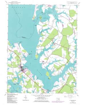
Saint Michaels Topo Map Maryland
To zoom in, hover over the map of Saint Michaels
USGS Topo Quad 38076g2 - 1:24,000 scale
| Topo Map Name: | Saint Michaels |
| USGS Topo Quad ID: | 38076g2 |
| Print Size: | ca. 21 1/4" wide x 27" high |
| Southeast Coordinates: | 38.75° N latitude / 76.125° W longitude |
| Map Center Coordinates: | 38.8125° N latitude / 76.1875° W longitude |
| U.S. State: | MD |
| Filename: | o38076g2.jpg |
| Download Map JPG Image: | Saint Michaels topo map 1:24,000 scale |
| Map Type: | Topographic |
| Topo Series: | 7.5´ |
| Map Scale: | 1:24,000 |
| Source of Map Images: | United States Geological Survey (USGS) |
| Alternate Map Versions: |
St. Michaels MD 1942, updated 1961 Download PDF Buy paper map St. Michaels MD 1942, updated 1977 Download PDF Buy paper map St. Michaels MD 1942, updated 1986 Download PDF Buy paper map Saint Michaels MD 2011 Download PDF Buy paper map Saint Michaels MD 2014 Download PDF Buy paper map Saint Michaels MD 2016 Download PDF Buy paper map |
1:24,000 Topo Quads surrounding Saint Michaels
> Back to 38076e1 at 1:100,000 scale
> Back to 38076a1 at 1:250,000 scale
> Back to U.S. Topo Maps home
Saint Michaels topo map: Gazetteer
Saint Michaels: Bays
Black Duck Cove elevation 2m 6′Blakes Cove elevation -1m -4′
Chapel Cove elevation 0m 0′
Darmands Creek elevation -1m -4′
Grocelys Cove elevation 2m 6′
Gross Creek elevation 0m 0′
Hambleton Cove elevation 0m 0′
Hayward Cove elevation 0m 0′
Leeds Creek elevation 0m 0′
Little Neck Creek elevation 3m 9′
Lloyd Creek elevation 0m 0′
Long Haul Creek elevation 0m 0′
Newcomb Creek elevation 2m 6′
Porter Creek elevation 0m 0′
Quarter Cove elevation 0m 0′
San Domingo Creek elevation 0m 0′
Shaw Bay elevation 0m 0′
Solitude Creek elevation 1m 3′
Spencer Creek elevation 0m 0′
Tide Mill Cove elevation 3m 9′
Woodland Creek elevation 0m 0′
Saint Michaels: Bridges
Miles River Bridge elevation 0m 0′Saint Michaels: Capes
Bennett Point elevation 1m 3′Bordley Point elevation 4m 13′
Church Neck Point elevation 1m 3′
Deepwater Point elevation 1m 3′
Fairview Point elevation 1m 3′
Hambleton Point elevation 0m 0′
Hopkins Point elevation 2m 6′
Long Point elevation 1m 3′
Maiden Point elevation 1m 3′
Miles River Neck elevation 4m 13′
Navy Point elevation 1m 3′
Parrott Point elevation 0m 0′
Point O' Pines elevation 1m 3′
Wyetown Point elevation 4m 13′
Saint Michaels: Crossings
Miles River Ferry (historical) elevation 0m 0′Saint Michaels: Islands
Bruffs Island elevation 4m 13′Hambleton Island elevation 0m 0′
Saint Michaels: Parks
Church Cove Park elevation 1m 3′Perry Cabin Park elevation 3m 9′
Saint Marys Square elevation 2m 6′
Saint Michaels Historic District elevation 2m 6′
Saint Michaels: Populated Places
Anchorage elevation 4m 13′Arcadia Shores elevation 3m 9′
Aveley elevation 3m 9′
Copperville elevation 3m 9′
Cove View elevation 2m 6′
Doncaster elevation 4m 13′
Doncaster (historical) elevation 4m 13′
Gullwing Villas elevation 3m 9′
Harper (historical) elevation 3m 9′
Ingleton elevation 3m 9′
Kirkham elevation 4m 13′
Leeds Landing elevation 3m 9′
Madison Place elevation 2m 6′
Martingham elevation 3m 9′
Mount Pleasant Farms elevation 3m 9′
Mulberry Point elevation 2m 6′
Newcomb elevation 2m 6′
North Bend Estates elevation 4m 13′
Porters Pride elevation 3m 9′
Quail Hollow elevation 4m 13′
Rays Point elevation 2m 6′
Rio Vista elevation 3m 9′
Riverside elevation 3m 9′
Saint Michaels elevation 2m 6′
Solitude elevation 3m 9′
Swan Villas elevation 3m 9′
Thanksgiving elevation 3m 9′
Tricfield elevation 2m 6′
Tunis Mills elevation 1m 3′
Unionville elevation 4m 13′
Saint Michaels: Post Offices
Newcomb Post Office elevation 2m 6′Saint Michaels Post Office elevation 2m 6′
Saint Michaels: Streams
Hunting Creek elevation 0m 0′Miles River elevation 0m 0′
Wye East River elevation 0m 0′
Wye River elevation 0m 0′
Saint Michaels digital topo map on disk
Buy this Saint Michaels topo map showing relief, roads, GPS coordinates and other geographical features, as a high-resolution digital map file on DVD:
Atlantic Coast (NY, NJ, PA, DE, MD, VA, NC)
Buy digital topo maps: Atlantic Coast (NY, NJ, PA, DE, MD, VA, NC)


