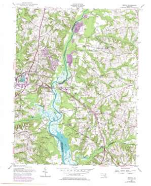
Bristol Topo Map Maryland
To zoom in, hover over the map of Bristol
USGS Topo Quad 38076g6 - 1:24,000 scale
| Topo Map Name: | Bristol |
| USGS Topo Quad ID: | 38076g6 |
| Print Size: | ca. 21 1/4" wide x 27" high |
| Southeast Coordinates: | 38.75° N latitude / 76.625° W longitude |
| Map Center Coordinates: | 38.8125° N latitude / 76.6875° W longitude |
| U.S. State: | MD |
| Filename: | o38076g6.jpg |
| Download Map JPG Image: | Bristol topo map 1:24,000 scale |
| Map Type: | Topographic |
| Topo Series: | 7.5´ |
| Map Scale: | 1:24,000 |
| Source of Map Images: | United States Geological Survey (USGS) |
| Alternate Map Versions: |
Bristol MD 1957 Download PDF Buy paper map Bristol MD 1957, updated 1958 Download PDF Buy paper map Bristol MD 1957, updated 1965 Download PDF Buy paper map Bristol MD 1957, updated 1972 Download PDF Buy paper map Bristol MD 1957, updated 1979 Download PDF Buy paper map Bristol MD 2011 Download PDF Buy paper map Bristol MD 2014 Download PDF Buy paper map Bristol MD 2016 Download PDF Buy paper map |
1:24,000 Topo Quads surrounding Bristol
> Back to 38076e1 at 1:100,000 scale
> Back to 38076a1 at 1:250,000 scale
> Back to U.S. Topo Maps home
Bristol topo map: Gazetteer
Bristol: Airports
Marlboro Heliport elevation 3m 9′Bristol: Bays
House Creek elevation 0m 0′Jug Bay elevation 0m 0′
Mondays Creek elevation 1m 3′
Railroad Creek elevation 0m 0′
Bristol: Bridges
Hills Bridge elevation 4m 13′Bristol: Capes
Billingsleys Point elevation 2m 6′McCalvert Point elevation 0m 0′
Pigg Point elevation 0m 0′
Bristol: Channels
Back Channel elevation 0m 0′Bristol: Islands
Spyglass Island elevation 1m 3′Bristol: Lakes
Chews Lake elevation 1m 3′Bristol: Parks
Jug Bay Wetlands Sanctuary elevation 1m 3′Route 260 Recreation Area elevation 31m 101′
Bristol: Populated Places
Baynard elevation 23m 75′Boones Mobile Estates elevation 29m 95′
Boone's Mobile Estates elevation 32m 104′
Bristol elevation 49m 160′
Bristol Landing elevation 1m 3′
Calvert Estates elevation 32m 104′
Century Manor elevation 40m 131′
Chaney elevation 44m 144′
Chaney Station elevation 42m 137′
Conte Manor elevation 37m 121′
Courtney Manor elevation 44m 144′
Croom Acres elevation 48m 157′
Darnall elevation 46m 150′
Drury elevation 13m 42′
Dunleigh elevation 26m 85′
Fox Chapel elevation 30m 98′
Green Landing elevation 0m 0′
Greenock elevation 49m 160′
Hawthorne Woods elevation 23m 75′
Heritage Hills elevation 42m 137′
Hunt Chapel elevation 31m 101′
Hunt Valley Estates elevation 43m 141′
Iron Pot Landing elevation 1m 3′
Jackson Landing elevation 13m 42′
Lahaina elevation 49m 160′
Leeland elevation 23m 75′
Leon elevation 14m 45′
Lothian Estates elevation 44m 144′
Lothian Woods elevation 29m 95′
Lyons Creek Hundred elevation 37m 121′
Lyons Creek Mobile Estates elevation 2m 6′
Marlboro Meadows elevation 30m 98′
Mary E White Estate elevation 28m 91′
Maryland Mobile Estates elevation 16m 52′
Mount Calvert elevation 7m 22′
Patuxent Mobile Estates elevation 17m 55′
Pindell elevation 24m 78′
Pond View Acres elevation 44m 144′
Portland Manor elevation 46m 150′
Reo Vista Plaza elevation 18m 59′
Rio Vista Plaza Mobile Home Park elevation 18m 59′
Rustic Knolls elevation 37m 121′
Selbys Landing elevation 1m 3′
Springfield elevation 25m 82′
The Sands elevation 20m 65′
Twin Shields Estates elevation 28m 91′
Upper Marlboro elevation 7m 22′
Waysons Corner elevation 14m 45′
Waysons Mobile Court elevation 14m 45′
Wells Corner elevation 48m 157′
Winding Brooke elevation 36m 118′
Bristol: Reservoirs
Depot Pond elevation 4m 13′Moreland Pond elevation 41m 134′
Bristol: Streams
Black Walnut Creek elevation 0m 0′Cabin Branch elevation 5m 16′
Charles Branch elevation 0m 0′
Collington Branch elevation 8m 26′
Deep Creek elevation 0m 0′
Deep Run Branch elevation 12m 39′
District Branch elevation 1m 3′
East Branch Collington Branch elevation 11m 36′
Federal Spring Branch elevation 6m 19′
Ferry Branch elevation 1m 3′
Galloway Creek elevation 0m 0′
Horse Tavern Branch elevation 1m 3′
Mill Creek elevation 0m 0′
Old Galloway Creek elevation 0m 0′
Pindell Branch elevation 1m 3′
Rock Branch elevation 4m 13′
Swan Point Creek elevation 0m 0′
Two Run Branch elevation 1m 3′
Western Branch Patuxent River elevation 0m 0′
Wilson Owens Branch elevation 1m 3′
Bristol: Swamps
Reed Marsh elevation 1m 3′Bristol digital topo map on disk
Buy this Bristol topo map showing relief, roads, GPS coordinates and other geographical features, as a high-resolution digital map file on DVD:
Atlantic Coast (NY, NJ, PA, DE, MD, VA, NC)
Buy digital topo maps: Atlantic Coast (NY, NJ, PA, DE, MD, VA, NC)


