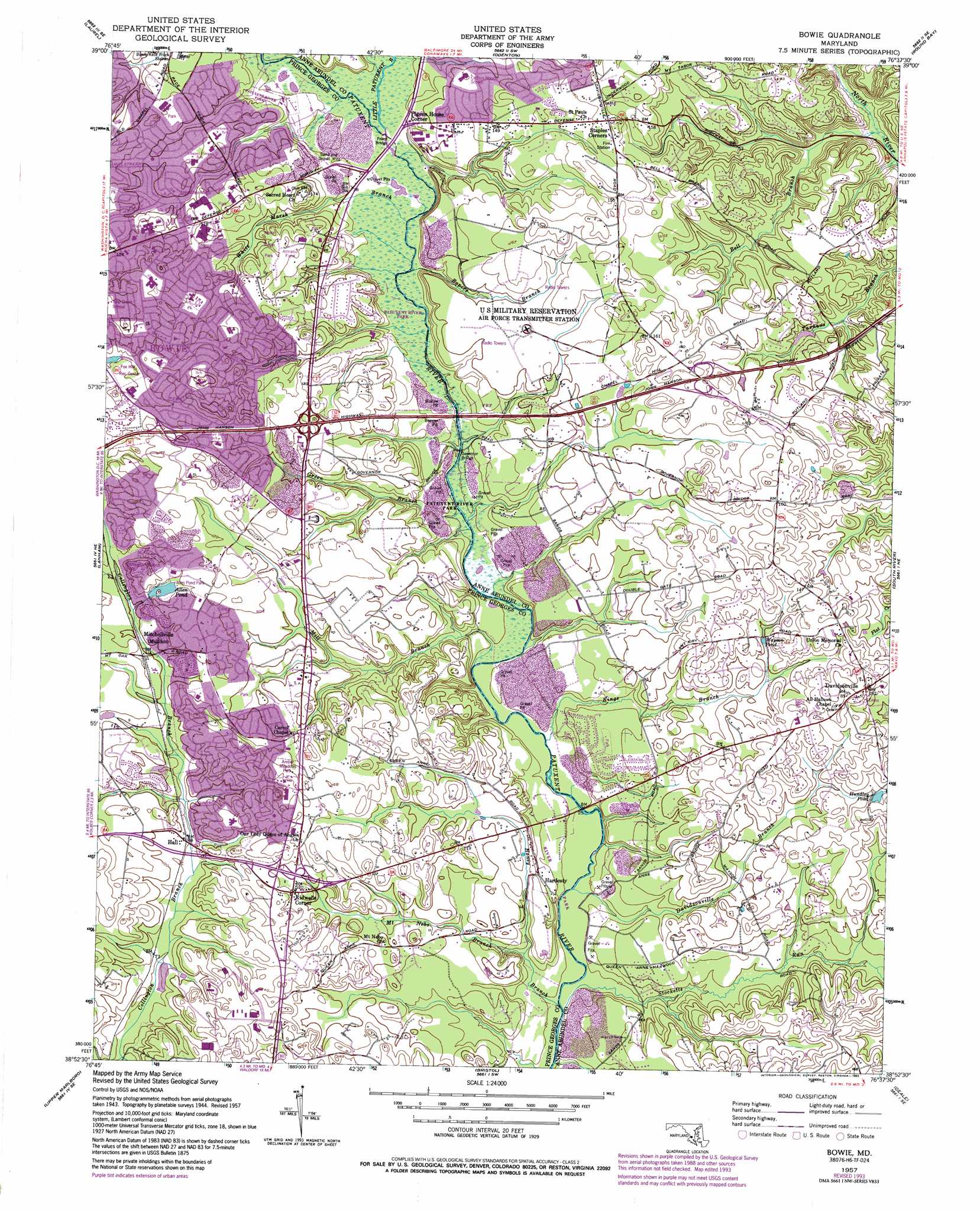
Bowie Topo Map Maryland
To zoom in, hover over the map of Bowie
USGS Topo Quad 38076h6 - 1:24,000 scale
| Topo Map Name: | Bowie |
| USGS Topo Quad ID: | 38076h6 |
| Print Size: | ca. 21 1/4" wide x 27" high |
| Southeast Coordinates: | 38.875° N latitude / 76.625° W longitude |
| Map Center Coordinates: | 38.9375° N latitude / 76.6875° W longitude |
| U.S. State: | MD |
| Filename: | o38076h6.jpg |
| Download Map JPG Image: | Bowie topo map 1:24,000 scale |
| Map Type: | Topographic |
| Topo Series: | 7.5´ |
| Map Scale: | 1:24,000 |
| Source of Map Images: | United States Geological Survey (USGS) |
| Alternate Map Versions: |
Davidsonville MD 1957, updated 1958 Download PDF Buy paper map Davidsonville MD 1957, updated 1965 Download PDF Buy paper map Bowie MD 1957, updated 1971 Download PDF Buy paper map Bowie MD 1957, updated 1978 Download PDF Buy paper map Bowie MD 1957, updated 1993 Download PDF Buy paper map Bowie MD 2011 Download PDF Buy paper map Bowie MD 2014 Download PDF Buy paper map Bowie MD 2016 Download PDF Buy paper map |
1:24,000 Topo Quads surrounding Bowie
Clarksville |
Savage |
Relay |
Curtis Bay |
Sparrows Point |
Beltsville |
Laurel |
Odenton |
Round Bay |
Gibson Island |
Washington East |
Lanham |
Bowie |
South River |
Annapolis |
Anacostia |
Upper Marlboro |
Bristol |
Deale |
|
Piscataway |
Brandywine |
Lower Marlboro |
North Beach |
> Back to 38076e1 at 1:100,000 scale
> Back to 38076a1 at 1:250,000 scale
> Back to U.S. Topo Maps home
Bowie topo map: Gazetteer
Bowie: Airports
Fairview Airport elevation 36m 118′Bowie: Bridges
Governor Bridge elevation 9m 29′Priest Bridge elevation 9m 29′
Queen Anne Bridge elevation 2m 6′
Bowie: Crossings
Interchange 11 elevation 54m 177′Interchange 13 elevation 38m 124′
Interchange 16 elevation 44m 144′
Bowie: Dams
Allen Pond Dam elevation 35m 114′Lake of the Pines Dam elevation 27m 88′
Bowie: Lakes
Wayson Pond elevation 31m 101′Bowie: Parks
Allen Pond Park elevation 38m 124′Amber Meadows Park elevation 39m 127′
Collington Branch Park elevation 30m 98′
Davidsonville Park elevation 48m 157′
Globecom Wildlife Management Area elevation 34m 111′
Heather Hills Park elevation 42m 137′
Patuxent River Watershed Park elevation 2m 6′
Pointer Ridge Recreation Area elevation 34m 111′
Riverwood Park elevation 22m 72′
Somerset Park elevation 40m 131′
White Marsh Park elevation 42m 137′
Bowie: Populated Places
Arrowhead Farms Estates elevation 35m 114′Bladen elevation 46m 150′
Cheston elevation 42m 137′
Cheval Trails elevation 35m 114′
Chinquapin Crest elevation 18m 59′
Crofton South elevation 42m 137′
Crofton Woods elevation 34m 111′
Davidsonville elevation 54m 177′
Davidsonville Farmettes elevation 50m 164′
Davidsonville Gardens elevation 15m 49′
Davidsonville Woods elevation 25m 82′
Essington elevation 47m 154′
Foxhall Estates elevation 41m 134′
Friends Choice elevation 44m 144′
Gravely elevation 36m 118′
Hall elevation 25m 82′
Hallmark Woods elevation 36m 118′
Hanson Hills elevation 34m 111′
Hardesty elevation 14m 45′
Heather Hills elevation 43m 141′
Heather Woods elevation 49m 160′
Hermitage Hill elevation 41m 134′
Huntington Woods elevation 41m 134′
Idlewild elevation 34m 111′
Kidwells Corner elevation 35m 114′
King Manor elevation 46m 150′
Kings Retreat elevation 44m 144′
Lake of the Pines elevation 33m 108′
Lavall elevation 31m 101′
Lavall Woods elevation 31m 101′
Meadowoods of Davidsonville elevation 42m 137′
Merrywood elevation 25m 82′
Merrywood Manor elevation 43m 141′
Mitchellville elevation 32m 104′
Overbrook elevation 33m 108′
Patuxent Manor elevation 23m 75′
Patuxent River Estates elevation 34m 111′
Pigeon House Corner elevation 16m 52′
Pin Oak Village elevation 42m 137′
Queen Anne Estates elevation 47m 154′
Queen Anne Knolls elevation 39m 127′
Riverwood elevation 19m 62′
Royale Glen elevation 33m 108′
Rutland elevation 33m 108′
Rutland Estates elevation 37m 121′
Sherwood Manor elevation 34m 111′
Stonegate Village elevation 42m 137′
Tara elevation 43m 141′
The Greens of Crofton elevation 45m 147′
Trails End Trailer Park elevation 8m 26′
Velmeade elevation 25m 82′
Bowie: Post Offices
Crofton Post Office elevation 30m 98′Davidsonville Post Office elevation 54m 177′
Bowie: Reservoirs
Allen Pond elevation 35m 114′Hundley Pond elevation 40m 131′
Lake Ruth elevation 27m 88′
Woodward Pond elevation 42m 137′
Bowie: Streams
Bell Branch elevation 4m 13′Black Branch elevation 22m 72′
Davidsonville Branch elevation 2m 6′
Green Branch elevation 5m 16′
Honey Branch elevation 1m 3′
Kings Branch elevation 4m 13′
Little Patuxent River elevation 9m 29′
Mill Branch elevation 5m 16′
Mount Nebo Branch elevation 9m 29′
Ropers Branch elevation 8m 26′
Stocketts Run elevation 8m 26′
White Marsh Branch elevation 7m 22′
Bowie digital topo map on disk
Buy this Bowie topo map showing relief, roads, GPS coordinates and other geographical features, as a high-resolution digital map file on DVD:
Atlantic Coast (NY, NJ, PA, DE, MD, VA, NC)
Buy digital topo maps: Atlantic Coast (NY, NJ, PA, DE, MD, VA, NC)
 map DVD")