Washington East Topo Map Maryland
To zoom in, hover over the map of Washington East
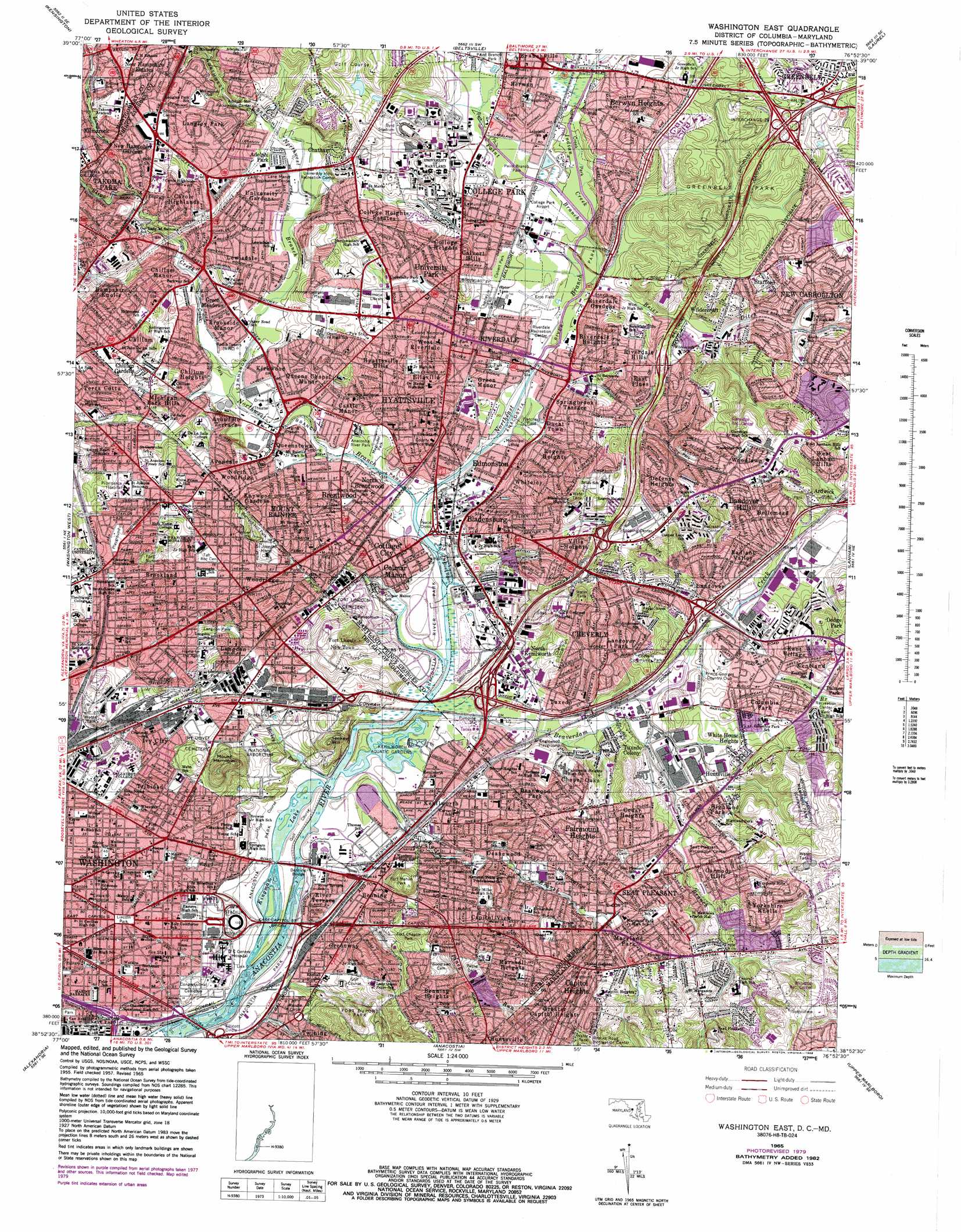
USGS Topo Quad 38076h8 - 1:24,000 scale
| Topo Map Name: | Washington East |
| USGS Topo Quad ID: | 38076h8 |
| Print Size: | ca. 21 1/4" wide x 27" high |
| Southeast Coordinates: | 38.875° N latitude / 76.875° W longitude |
| Map Center Coordinates: | 38.9375° N latitude / 76.9375° W longitude |
| U.S. States: | MD, DC |
| Filename: | o38076h8.jpg |
| Download Map JPG Image: | Washington East topo map 1:24,000 scale |
| Map Type: | Topographic |
| Topo Series: | 7.5´ |
| Map Scale: | 1:24,000 |
| Source of Map Images: | United States Geological Survey (USGS) |
| Alternate Map Versions: |
Washington East DC 1951 Download PDF Buy paper map Washington East DC 1956, updated 1959 Download PDF Buy paper map Washington East DC 1957, updated 1962 Download PDF Buy paper map Washington East DC 1965, updated 1966 Download PDF Buy paper map Washington East DC 1965, updated 1971 Download PDF Buy paper map Washington East DC 1965, updated 1979 Download PDF Buy paper map Washington East DC 1965, updated 1983 Download PDF Buy paper map Washington East DC 1965, updated 1988 Download PDF Buy paper map Washington East DC 2011 Download PDF Buy paper map Washington East DC 2014 Download PDF Buy paper map Washington East DC 2016 Download PDF Buy paper map |
1:24,000 Topo Quads surrounding Washington East
Gaithersburg |
Sandy Spring |
Clarksville |
Savage |
Relay |
Rockville |
Kensington |
Beltsville |
Laurel |
Odenton |
Falls Church |
Washington West |
Washington East |
Lanham |
Bowie |
Annandale |
Alexandria |
Anacostia |
Upper Marlboro |
Bristol |
Fort Belvoir |
Mount Vernon |
Piscataway |
Brandywine |
Lower Marlboro |
> Back to 38076e1 at 1:100,000 scale
> Back to 38076a1 at 1:250,000 scale
> Back to U.S. Topo Maps home
Washington East topo map: Gazetteer
Washington East: Airports
College Park Airport elevation 13m 42′District of Columbia General Hospital ACCC Heliport elevation 12m 39′
MPD 5th Heliport elevation 20m 65′
Prince Georges Hospital Center Heliport elevation 59m 193′
Queen Chapel Airport (historical) elevation 9m 29′
Schrom Airport (historical) elevation 38m 124′
Washington East: Areas
Fort Dupont Maintenance Yard elevation 16m 52′Washington East: Bridges
Anacostia Railroad Bridge elevation 1m 3′Benning Bridge elevation 2m 6′
Charles Richard Drew Bridge elevation 42m 137′
John Phillip Sousa Bridge elevation 2m 6′
Whitney Young Memorial Bridge elevation 4m 13′
Washington East: Capes
Evans Point elevation 1m 3′Tete Du Pont elevation 8m 26′
Washington East: Channels
Navy Yard Channel elevation 1m 3′Washington East: Crossings
Interchange 22 elevation 48m 157′Interchange 5 elevation 21m 68′
Washington East: Islands
Burnham Barrier elevation 3m 9′Washington East: Lakes
Kingman Lake elevation 0m 0′Washington East: Parks
Abraham Lincoln/Emancipation Monument elevation 27m 88′Adelphi Mill Recreation Center elevation 29m 95′
Anacostia Park elevation 5m 16′
Anacostia Park Section E elevation 3m 9′
Anacostia Park Section F elevation 2m 6′
Anacostia Park Section G elevation 2m 6′
Anacostia River Park elevation 5m 16′
Arboretum Recreation Center elevation 20m 65′
Backus Recreation Center elevation 37m 121′
Barnard Hill Park elevation 51m 167′
Benning Park elevation 44m 144′
Benning Park Community Center elevation 44m 144′
Benning Park Recreation Center elevation 53m 173′
Benning Stoddert Recreation Center elevation 24m 78′
Benning Terrace Community Center elevation 51m 167′
Benning Terrace Recreation Center elevation 57m 187′
Bison Sculpture elevation 23m 75′
Brentwood Park elevation 39m 127′
Brentwood Recreation Center elevation 37m 121′
Brentwood Village Playground elevation 49m 160′
Brooks Road Recreation Center elevation 61m 200′
Byrd Stadium elevation 37m 121′
Calvert Park elevation 16m 52′
Capitol View Plaza elevation 24m 78′
Capper Recreation Center elevation 8m 26′
Cheverly Community Park elevation 27m 88′
Cheverly Local Park elevation 35m 114′
Colby Park elevation 55m 180′
Contrapposto Sculpture elevation 25m 82′
Dakota Playground elevation 23m 75′
Deanwood Recreation Center elevation 9m 29′
East Capitol Community Center elevation 32m 104′
Edgewood Terrace Recreation Center elevation 49m 160′
Edward Miner Gallaudet Statue elevation 24m 78′
Eliot Recreation Center elevation 14m 45′
Emancipation Monument elevation 27m 88′
Evans Recreation Center elevation 38m 124′
Fairmount Heights Park elevation 31m 101′
Father Godfrey Schilling Statue elevation 55m 180′
Fletcher-Johnson Recreation Center elevation 30m 98′
Fletchers Field elevation 9m 29′
Fort Bunker Hill Park elevation 67m 219′
Fort Chaplin Park elevation 38m 124′
Fort Dupont Park elevation 51m 167′
Fort Dupont Park Skating Rink elevation 49m 160′
Fort Dupont Playground elevation 52m 170′
Fort Dupont Pool elevation 60m 196′
Fort Lincoln Recreation Center elevation 23m 75′
Fort Mahan Park elevation 50m 164′
Freedmen Memorial elevation 27m 88′
Gallaudet Thomas Hopkins and Alice Cogswell Statue elevation 23m 75′
Glenridge Recreation Center elevation 62m 203′
Green Valley Senior Citizens Center elevation 22m 72′
Greenbelt Park elevation 32m 104′
Harris Recreation Center elevation 49m 160′
Hine Recreation Center elevation 10m 32′
Hyattsville Historic District elevation 17m 55′
Indian Creek Park elevation 15m 49′
Joseph Cole Recreation Center elevation 20m 65′
Kelly Miller Pool elevation 29m 95′
Kelly Miller Recreation Center elevation 32m 104′
Kenilworth Aquatic Gardens elevation 3m 9′
Kenilworth-Parkside Recreation Center elevation 5m 16′
Kentland Park elevation 17m 55′
Kimball Playground elevation 20m 65′
Lane Manor Recreation Center elevation 20m 65′
Langdon Park elevation 29m 95′
Langdon Park Recreation Center elevation 42m 137′
Langdon Pool elevation 23m 75′
Langston Playground elevation 10m 32′
Lincoln Capper Walk to Learn Pool elevation 6m 19′
Lincoln Park elevation 27m 88′
Lincoln Playground elevation 7m 22′
Loomis Park elevation 27m 88′
Ludlow/Taylor Recreation Center elevation 10m 32′
Magruder Park elevation 5m 16′
Major General Nathanael Green Statue elevation 25m 82′
Marion Park elevation 22m 72′
Marvin Gaye Recreation Center elevation 25m 82′
Mary McLeod Bethune Statue elevation 27m 88′
Maury Recreation Center elevation 26m 85′
Millwood Recreation Center elevation 70m 229′
Montana Terrace Recreation Center elevation 18m 59′
Mount Rainier Historic District elevation 24m 78′
Mount Rainier Neighborhood Park elevation 8m 26′
National Arboretum elevation 21m 68′
Neighborhood Park elevation 23m 75′
North Englewood Playground elevation 4m 13′
North Michigan Park Recreation Center elevation 23m 75′
Noyes Playground elevation 45m 147′
Noyes Recreation Center elevation 47m 154′
Olive Risely Seward Statue elevation 25m 82′
Parkside Playground elevation 5m 16′
Payne Playground elevation 23m 75′
Payne Recreation Center elevation 23m 75′
Peabody Recreation Center elevation 25m 82′
Potomac Gardens Recreation Center elevation 18m 59′
Ridge Playground elevation 61m 200′
Ridge Recreation Center elevation 59m 193′
Riggs LaSalle Recreation Center elevation 48m 157′
Riggs Road Playground elevation 45m 147′
River Terrace Recreation Center elevation 8m 26′
Riverdale Recreation Center elevation 9m 29′
Robert F Kennedy Memorial Stadium elevation 7m 22′
Roper Recreation Center elevation 9m 29′
Rosedale Playground elevation 8m 26′
Rosedale Recreation Center elevation 10m 32′
Saint Bernadette Statue elevation 56m 183′
Saint Christopher Statue elevation 55m 180′
Saint Dominic Statue elevation 60m 196′
Saint Francis and the Turtledoves Statue elevation 47m 154′
Saint Jerome the Priest Statue elevation 63m 206′
Saint Vincent De Paul Statue elevation 39m 127′
Seat Pleasant Recreation Center elevation 20m 65′
Seward Square elevation 25m 82′
Sherwood Playground elevation 13m 42′
Sherwood Recreation Center elevation 12m 39′
Spingarn-Langston Recreation Center elevation 18m 59′
Stanton Park elevation 25m 82′
Taft Recreation Center elevation 23m 75′
Thomas Hopkins Gallaudet Statue elevation 21m 68′
Trinidad Playground elevation 31m 101′
Trinidad Recreation Center elevation 30m 98′
Turkey Thicket Playground elevation 40m 131′
Turkey Thicket Recreation Center elevation 38m 124′
University Hills Recreation Center elevation 20m 65′
Virginia Avenue Playground (historical) elevation 17m 55′
Virginia Avenue Recreation Center elevation 16m 52′
Watkins Recreation Center elevation 24m 78′
Watts Branch Parkway elevation 16m 52′
Watts Branch Playground elevation 24m 78′
Watts Branch Recreation Center elevation 25m 82′
Wheatley Playground elevation 22m 72′
William H Rumsey Aquatic Facility elevation 25m 82′
Woodson Junior Recreation Center elevation 16m 52′
Woodson Senior Recreation Center elevation 19m 62′
Washington East: Populated Places
Adelphi Park elevation 22m 72′Ardwick elevation 50m 164′
Avondale elevation 31m 101′
Avondale Terrace elevation 30m 98′
Bellemead elevation 34m 111′
Benning elevation 14m 45′
Benning Heights elevation 55m 180′
Berwyn elevation 21m 68′
Berwyn Heights elevation 33m 108′
Bladensburg elevation 15m 49′
Branchville elevation 21m 68′
Brentwood elevation 8m 26′
Brentwood Village elevation 45m 147′
Brookland elevation 47m 154′
Brookside Manor elevation 15m 49′
Browns Corner elevation 68m 223′
Calvert Hills elevation 23m 75′
Canonbury Square elevation 62m 203′
Capitol Heights elevation 38m 124′
Capitol View elevation 30m 98′
Carmody Hills elevation 36m 118′
Carole Highlands elevation 62m 203′
Castle Manor elevation 16m 52′
Cedar Heights elevation 40m 131′
Central Northeast elevation 37m 121′
Chapel Oaks elevation 29m 95′
Chatham elevation 38m 124′
Cheverly elevation 54m 177′
Chillum elevation 45m 147′
Chillum Gardens elevation 33m 108′
Chillum Heights elevation 23m 75′
Chillum Manor elevation 38m 124′
Chillum Terrace elevation 16m 52′
Clark Mills Estate Subdivision (historical) elevation 40m 131′
College Heights elevation 26m 85′
College Heights Estates elevation 34m 111′
College Park elevation 21m 68′
Colmar Manor elevation 9m 29′
Columbia Park elevation 28m 91′
Cottage City elevation 9m 29′
Deanwood elevation 13m 42′
Deanwood Park elevation 22m 72′
Defense Heights elevation 60m 196′
Dodge Park elevation 41m 134′
Ducat Town elevation 20m 65′
East Pines elevation 41m 134′
East Riverdale elevation 11m 36′
East Washington Heights elevation 20m 65′
Eastland Gardens elevation 4m 13′
Edgewood Terrace elevation 40m 131′
Edmonston elevation 5m 16′
Ellaville elevation 31m 101′
Fairmount Heights elevation 31m 101′
Fort Lincoln New Town elevation 42m 137′
Gateway elevation 22m 72′
Greater Capitol Heights elevation 57m 187′
Green Manor elevation 8m 26′
Green Meadows elevation 16m 52′
Greenway elevation 22m 72′
Hampshire Knolls elevation 39m 127′
Highland elevation 20m 65′
Highland Park elevation 23m 75′
Huntsville elevation 27m 88′
Hyattsville elevation 32m 104′
Hyattsville Hills elevation 27m 88′
Isherwood elevation 11m 36′
Ivy City elevation 23m 75′
Kaywood Gardens elevation 28m 91′
Kenilworth elevation 10m 32′
Kent Village elevation 30m 98′
Kentland elevation 33m 108′
Kilmarock elevation 60m 196′
Kingman Park elevation 21m 68′
Kirkwood elevation 14m 45′
Lakeland elevation 18m 59′
Landover elevation 17m 55′
Landover Hills elevation 50m 164′
Landover Park elevation 36m 118′
Langdon elevation 30m 98′
Langley Park elevation 46m 150′
Lewisdale elevation 23m 75′
Lincoln Heights elevation 47m 154′
Lincoln Park elevation 22m 72′
Marshall Heights elevation 48m 157′
Maryland Park elevation 30m 98′
Mayfair-Parkside elevation 7m 22′
Michigan Park elevation 27m 88′
Michigan Park Hills elevation 18m 59′
Monastery Lot (historical) elevation 23m 75′
Morris Addition (historical) elevation 14m 45′
Mount Rainier elevation 23m 75′
Nacocktanke (historical) elevation 10m 32′
Nacotchtanke (historical) elevation 9m 29′
New Carrollton elevation 23m 75′
New Hampshire Estates elevation 71m 232′
New Hampshire Gardens elevation 60m 196′
North Avondale elevation 19m 62′
North Brentwood elevation 4m 13′
North Kenilworth elevation 11m 36′
North Michigan Park elevation 21m 68′
North Woodridge elevation 17m 55′
Northeast Boundary elevation 24m 78′
Peppermill Village elevation 60m 196′
Pipetown (historical) elevation 18m 59′
Queens Chapel Manor elevation 19m 62′
Queenstown elevation 8m 26′
Radiant Valley elevation 26m 85′
Riggs Park elevation 47m 154′
River Terrace elevation 9m 29′
Riverdale Gardens elevation 22m 72′
Riverdale Heights elevation 28m 91′
Riverdale Hills elevation 32m 104′
Riverdale Park elevation 12m 39′
Rives elevation 22m 72′
Rogers Heights elevation 31m 101′
Rosedale elevation 8m 26′
Seat Pleasant elevation 33m 108′
Southeast elevation 19m 62′
Springbrook Terrace elevation 36m 118′
Stafford elevation 40m 131′
Stanton Park elevation 11m 36′
Terra Cotta elevation 36m 118′
Trinidad elevation 31m 101′
Tuxedo elevation 31m 101′
Tuxedo Colony elevation 35m 114′
University Gardens elevation 23m 75′
University Heights elevation 40m 131′
University Park elevation 22m 72′
Villa Heights elevation 46m 150′
Walker Mill elevation 61m 200′
West Lanham Hills elevation 32m 104′
West Riverdale elevation 23m 75′
White House Heights elevation 27m 88′
Whiteley elevation 17m 55′
Wildercroft elevation 42m 137′
Woodlawn elevation 47m 154′
Woodridge elevation 45m 147′
Yorkshire Knolls elevation 46m 150′
Washington East: Post Offices
Benning Post Office elevation 12m 39′Berwyn Heights Post Office elevation 21m 68′
Bladensburg Post Office elevation 12m 39′
Brentwood Post Office elevation 10m 32′
Brookland Post Office elevation 54m 177′
Calvert Post Office elevation 16m 52′
Capitol Heights Post Office elevation 43m 141′
Catholic University Post Office elevation 64m 209′
Customs House Post Office elevation 29m 95′
Joseph Curseen Junior and Thomas Morris Junior Processing and Distribution Center elevation 37m 121′
Landover Hills Post Office elevation 51m 167′
Mount Rainier Post Office elevation 18m 59′
Northeast Station Post Office elevation 13m 42′
River Terrace Post Office elevation 10m 32′
Riverdale Post Office elevation 20m 65′
Southeast Station Post Office elevation 24m 78′
Washington District of Columbia Main Office Post Office elevation 37m 121′
Washington Navy Yard Finance Station Post Office elevation 11m 36′
Woodridge Post Office elevation 45m 147′
Washington East: Springs
Federal Spring (historical) elevation 15m 49′Gibsons Spring (historical) elevation 11m 36′
Washington East: Streams
Beaverdam Creek elevation 2m 6′Bennings Branch (historical) elevation 12m 39′
Brier Ditch elevation 9m 29′
Cabin Branch elevation 8m 26′
Cattail Branch elevation 12m 39′
Hickey Run elevation 0m 0′
Indian Creek elevation 28m 91′
Long Branch elevation 29m 95′
Northeast Branch Anacostia River elevation 4m 13′
Northwest Branch Anacostia River elevation 4m 13′
Paint Branch elevation 32m 104′
Piney Run elevation 17m 55′
Piney Run elevation 17m 55′
Pope Branch elevation 0m 0′
Sligo Creek elevation 9m 29′
Spring Branch (historical) elevation 1m 3′
Takoma Branch elevation 19m 62′
Watts Branch elevation 1m 3′
Watts Branch elevation 2m 6′
Washington East: Summits
Barnard Hill elevation 55m 180′Bunker Hill elevation 71m 232′
Fort Bunker Hill elevation 70m 229′
Hickey Hill elevation 40m 131′
Hoover Hill elevation 56m 183′
Licking Banks elevation 9m 29′
Mount Hamilton elevation 71m 232′
Mount Saint Sepulchre elevation 56m 183′
Round Hill elevation 61m 200′
Washington East digital topo map on disk
Buy this Washington East topo map showing relief, roads, GPS coordinates and other geographical features, as a high-resolution digital map file on DVD:
Atlantic Coast (NY, NJ, PA, DE, MD, VA, NC)
Buy digital topo maps: Atlantic Coast (NY, NJ, PA, DE, MD, VA, NC)
 map DVD")