Rollins Fork Topo Map Virginia
To zoom in, hover over the map of Rollins Fork
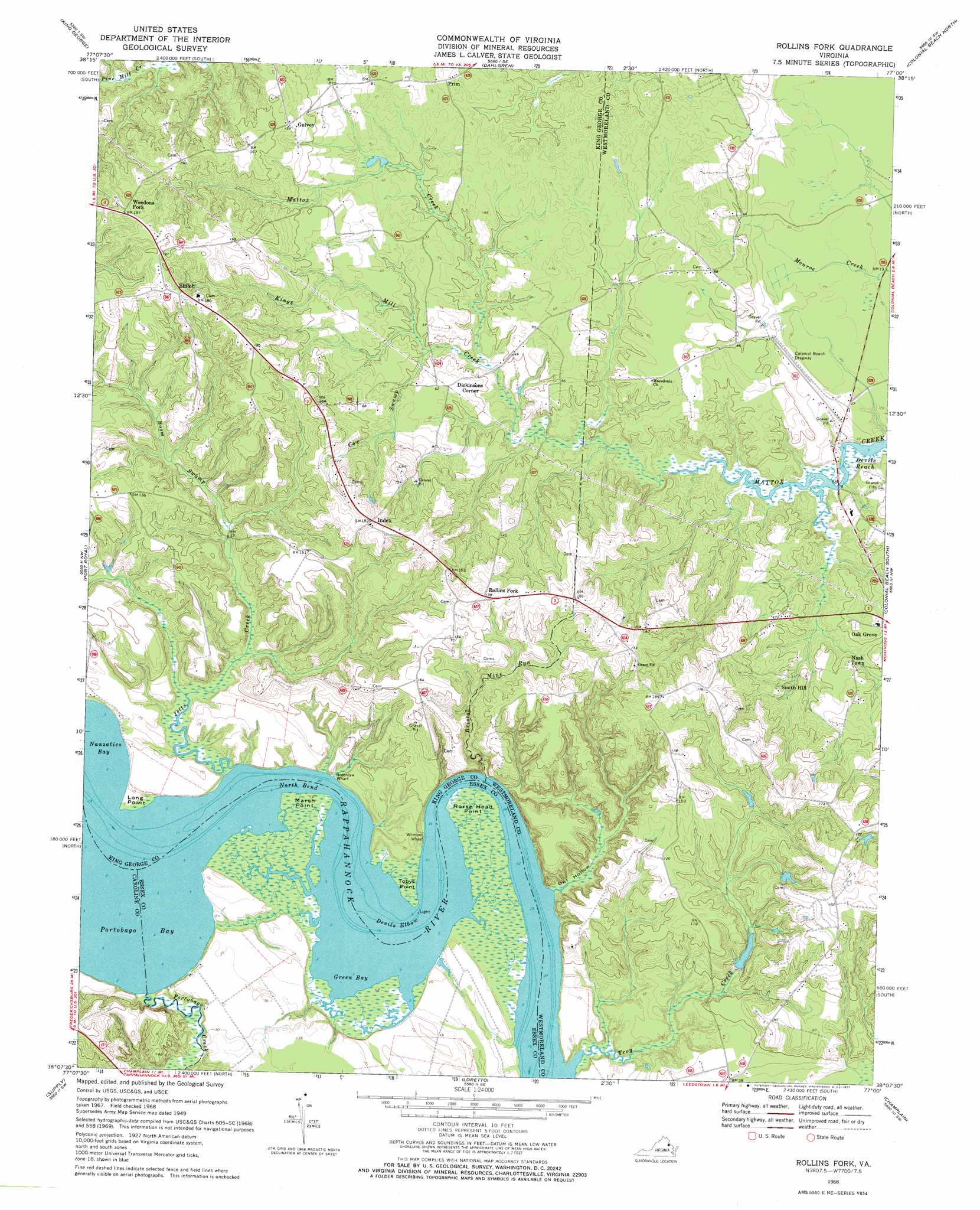
USGS Topo Quad 38077b1 - 1:24,000 scale
| Topo Map Name: | Rollins Fork |
| USGS Topo Quad ID: | 38077b1 |
| Print Size: | ca. 21 1/4" wide x 27" high |
| Southeast Coordinates: | 38.125° N latitude / 77° W longitude |
| Map Center Coordinates: | 38.1875° N latitude / 77.0625° W longitude |
| U.S. State: | VA |
| Filename: | o38077b1.jpg |
| Download Map JPG Image: | Rollins Fork topo map 1:24,000 scale |
| Map Type: | Topographic |
| Topo Series: | 7.5´ |
| Map Scale: | 1:24,000 |
| Source of Map Images: | United States Geological Survey (USGS) |
| Alternate Map Versions: |
Rollins Fork VA 1949, updated 1961 Download PDF Buy paper map Rollins Fork VA 1968, updated 1971 Download PDF Buy paper map Rollins Fork VA 2011 Download PDF Buy paper map Rollins Fork VA 2013 Download PDF Buy paper map Rollins Fork VA 2016 Download PDF Buy paper map |
1:24,000 Topo Quads surrounding Rollins Fork
Widewater |
Nanjemoy |
Mathias Point |
Popes Creek |
Charlotte Hall |
Passapatanzy |
King George |
Dahlgren |
Colonial Beach North |
Rock Point |
Rappahannock Academy |
Port Royal |
Rollins Fork |
Colonial Beach South |
Stratford Hall |
Bowling Green |
Supply |
Loretto |
Champlain |
Montross |
Penola |
Sparta |
Cauthornville |
Mount Landing |
Tappahannock |
> Back to 38077a1 at 1:100,000 scale
> Back to 38076a1 at 1:250,000 scale
> Back to U.S. Topo Maps home
Rollins Fork topo map: Gazetteer
Rollins Fork: Bars
Nanzatico Bar elevation 1m 3′Rollins Fork: Bays
Green Bay elevation 1m 3′Nanzatico Bay elevation 0m 0′
Portobago Bay elevation 1m 3′
Rollins Fork: Bends
Devils Elbow elevation 1m 3′North Bend elevation 0m 0′
Rollins Fork: Bridges
Mattox Bridge elevation 3m 9′Rollins Fork: Capes
Horse Head Point elevation 2m 6′Long Point elevation 1m 3′
Marsh Point elevation 2m 6′
Tobys Point elevation 1m 3′
Rollins Fork: Crossings
Mattox Ferry (historical) elevation 3m 9′Rollins Fork: Dams
Flemmer Dam elevation 8m 26′Rollins Fork: Parks
Lands End Wildlife Management Area elevation 5m 16′Rollins Fork: Populated Places
Dickinsons Corner elevation 19m 62′Gulvey elevation 41m 134′
Leesville elevation 31m 101′
Mattox Bridge elevation 6m 19′
Nash Town elevation 16m 52′
Pomona elevation 21m 68′
Prim elevation 21m 68′
Rollins Fork elevation 53m 173′
Shiloh elevation 55m 180′
Smith Hill elevation 23m 75′
Weedons Fork elevation 59m 193′
Wilmot elevation 8m 26′
Rollins Fork: Reservoirs
Flemmer Pond elevation 8m 26′Rollins Fork: Streams
Boom Swamp elevation 10m 32′Bristol Mine Run elevation 1m 3′
Cone Creek elevation 0m 0′
Cow Swamp elevation 11m 36′
Jetts Creek elevation 0m 0′
Kings Mill Creek elevation 9m 29′
Portobago Creek elevation 1m 3′
Troy Creek elevation 0m 0′
Rollins Fork: Valleys
Owl Hollow elevation 1m 3′Rollins Fork digital topo map on disk
Buy this Rollins Fork topo map showing relief, roads, GPS coordinates and other geographical features, as a high-resolution digital map file on DVD:
Atlantic Coast (NY, NJ, PA, DE, MD, VA, NC)
Buy digital topo maps: Atlantic Coast (NY, NJ, PA, DE, MD, VA, NC)
 map DVD")