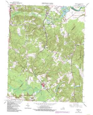
Guinea Topo Map Virginia
To zoom in, hover over the map of Guinea
USGS Topo Quad 38077b4 - 1:24,000 scale
| Topo Map Name: | Guinea |
| USGS Topo Quad ID: | 38077b4 |
| Print Size: | ca. 21 1/4" wide x 27" high |
| Southeast Coordinates: | 38.125° N latitude / 77.375° W longitude |
| Map Center Coordinates: | 38.1875° N latitude / 77.4375° W longitude |
| U.S. State: | VA |
| Filename: | o38077b4.jpg |
| Download Map JPG Image: | Guinea topo map 1:24,000 scale |
| Map Type: | Topographic |
| Topo Series: | 7.5´ |
| Map Scale: | 1:24,000 |
| Source of Map Images: | United States Geological Survey (USGS) |
| Alternate Map Versions: |
Guinea VA 1949, updated 1961 Download PDF Buy paper map Guinea VA 1966, updated 1968 Download PDF Buy paper map Guinea VA 1966, updated 1973 Download PDF Buy paper map Guinea VA 1966, updated 1984 Download PDF Buy paper map Guinea VA 1966, updated 2000 Download PDF Buy paper map Guinea VA 2010 Download PDF Buy paper map Guinea VA 2013 Download PDF Buy paper map Guinea VA 2016 Download PDF Buy paper map |
1:24,000 Topo Quads surrounding Guinea
> Back to 38077a1 at 1:100,000 scale
> Back to 38076a1 at 1:250,000 scale
> Back to U.S. Topo Maps home
Guinea topo map: Gazetteer
Guinea: Bends
Dangerfield Short Turn elevation 0m 0′Guinea: Crossings
Interchange 126 elevation 52m 170′Guinea: Dams
Daltons Dam elevation 37m 121′E H Mills Memorial Dam elevation 9m 29′
Guinea: Lakes
Haislip Pond elevation 18m 59′Meadow Creek Pond elevation 49m 160′
Guinea: Parks
Lee Hill Park elevation 69m 226′Guinea: Populated Places
Belvedere elevation 16m 52′Carters Store elevation 66m 216′
Claiborne elevation 46m 150′
Corbin elevation 65m 213′
Daltons elevation 39m 127′
Flippos Corner elevation 51m 167′
Glenwood Mobile Home Court elevation 69m 226′
Greenfield elevation 21m 68′
Guinea elevation 41m 134′
Hamilton Crossing elevation 25m 82′
Lee's Hill Mobile Home Park elevation 67m 219′
Locks Corner elevation 72m 236′
Long Branch elevation 69m 226′
Massaponax elevation 27m 88′
New Post elevation 20m 65′
Olive elevation 45m 147′
The Oaks Mobile Home Park elevation 67m 219′
Villboro elevation 69m 226′
Guinea: Reservoirs
Dalton Millpond elevation 37m 121′Daltons Millpond elevation 43m 141′
Ruffins Pond elevation 9m 29′
Ruffins Pond elevation 3m 9′
Guinea: Streams
Ni River elevation 36m 118′Po River elevation 36m 118′
Guinea digital topo map on disk
Buy this Guinea topo map showing relief, roads, GPS coordinates and other geographical features, as a high-resolution digital map file on DVD:
Atlantic Coast (NY, NJ, PA, DE, MD, VA, NC)
Buy digital topo maps: Atlantic Coast (NY, NJ, PA, DE, MD, VA, NC)


