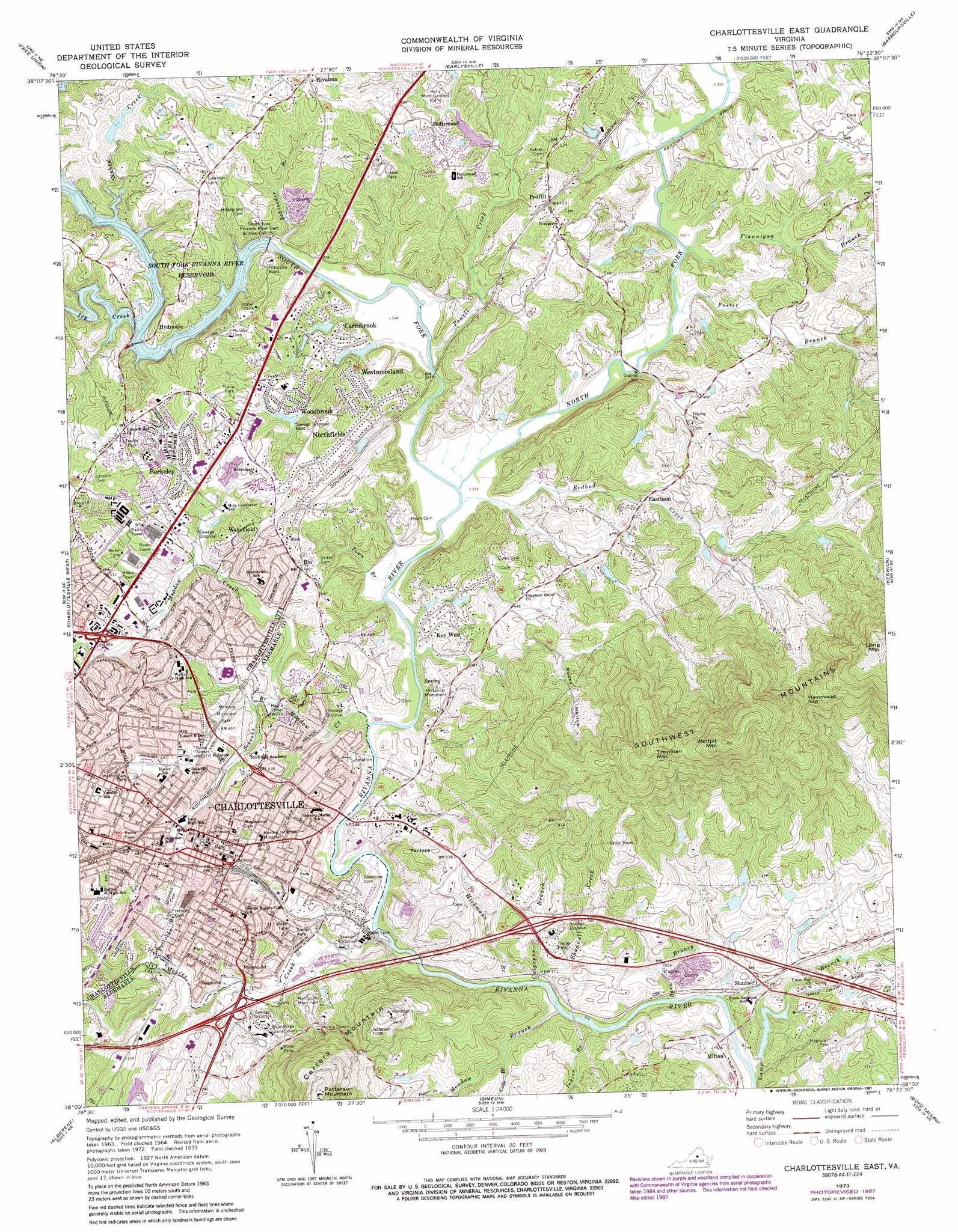
Charlottesville East Topo Map Virginia
To zoom in, hover over the map of Charlottesville East
USGS Topo Quad 38078a4 - 1:24,000 scale
| Topo Map Name: | Charlottesville East |
| USGS Topo Quad ID: | 38078a4 |
| Print Size: | ca. 21 1/4" wide x 27" high |
| Southeast Coordinates: | 38° N latitude / 78.375° W longitude |
| Map Center Coordinates: | 38.0625° N latitude / 78.4375° W longitude |
| U.S. State: | VA |
| Filename: | o38078a4.jpg |
| Download Map JPG Image: | Charlottesville East topo map 1:24,000 scale |
| Map Type: | Topographic |
| Topo Series: | 7.5´ |
| Map Scale: | 1:24,000 |
| Source of Map Images: | United States Geological Survey (USGS) |
| Alternate Map Versions: |
Charlottesville East VA 1964, updated 1965 Download PDF Buy paper map Charlottesville East VA 1964, updated 1968 Download PDF Buy paper map Charlottesville East VA 1972, updated 1974 Download PDF Buy paper map Charlottesville East VA 1973, updated 1974 Download PDF Buy paper map Charlottesville East VA 1973, updated 1978 Download PDF Buy paper map Charlottesville East VA 1973, updated 1987 Download PDF Buy paper map Charlottesville East VA 1977, updated 1982 Download PDF Buy paper map Charlottesville East VA 1997, updated 1999 Download PDF Buy paper map Charlottesville East VA 2011 Download PDF Buy paper map Charlottesville East VA 2013 Download PDF Buy paper map Charlottesville East VA 2016 Download PDF Buy paper map |
1:24,000 Topo Quads surrounding Charlottesville East
Mcgaheysville |
Swift Run Gap |
Stanardsville |
Rochelle |
Madison Mills |
Browns Cove |
Free Union |
Earlysville |
Barboursville |
Gordonsville |
Crozet |
Charlottesville West |
Charlottesville East |
Keswick |
Boswells Tavern |
Covesville |
Alberene |
Simeon |
Boyd Tavern |
Zion Crossroads |
Schuyler |
Esmont |
Scottsville |
Palmyra |
Columbia |
> Back to 38078a1 at 1:100,000 scale
> Back to 38078a1 at 1:250,000 scale
> Back to U.S. Topo Maps home
Charlottesville East topo map: Gazetteer
Charlottesville East: Airports
University of Virginia Hospital Heliport elevation 154m 505′Charlottesville East: Bridges
Free Bridge elevation 97m 318′Charlottesville East: Crossings
Interchange 121 elevation 107m 351′Interchange 124 elevation 133m 436′
Secretarys Ford elevation 91m 298′
Charlottesville East: Dams
Baileys Dam elevation 107m 351′Edgehill Farm Dam Number Two elevation 135m 442′
Grahams Dam elevation 132m 433′
Holly Mead Dam Number Two elevation 140m 459′
Hurts Dam elevation 132m 433′
Hurtts Dam elevation 88m 288′
Murrays Dam elevation 133m 436′
Northfields Dam elevation 131m 429′
Paines Dam elevation 108m 354′
South Fork Rivanna River Dam elevation 109m 357′
South Rivanna Dam elevation 119m 390′
Charlottesville East: Gaps
Hammocks Gap elevation 279m 915′Charlottesville East: Parks
Albemarle Historic District elevation 153m 501′Belmont Park elevation 135m 442′
Charlottesville and Albemarle County Historic District elevation 146m 479′
Darden Towne Memorial Park elevation 135m 442′
Forrest Hills Park elevation 133m 436′
George Rogers Clark Statue elevation 152m 498′
Greenbriar Park elevation 112m 367′
Greenleaf Park elevation 135m 442′
Ivy Creek Park elevation 148m 485′
Jackson Park elevation 153m 501′
Jordan Avenue Park elevation 106m 347′
Lee Park elevation 146m 479′
Lewis and Clark Memorial elevation 147m 482′
Main Street Mall elevation 140m 459′
McIntire Municipal Park elevation 141m 462′
Meade Park elevation 102m 334′
Pen Park elevation 133m 436′
Quarry Park elevation 103m 337′
R E Lee Monument elevation 146m 479′
Ridge Street Historic District elevation 148m 485′
Rivanna Park elevation 107m 351′
Rives Park elevation 103m 337′
T J Jackson Monument elevation 153m 501′
Tonsler Park elevation 129m 423′
Washington Park elevation 149m 488′
Wertland Street Historic District elevation 155m 508′
Charlottesville East: Populated Places
Ardwood elevation 133m 436′Ashcroft elevation 184m 603′
Barterbrook elevation 160m 524′
Bedford Hills elevation 167m 547′
Bell Haven elevation 147m 482′
Belmont elevation 147m 482′
Bentivar elevation 153m 501′
Berkeley elevation 143m 469′
Berkmar elevation 152m 498′
Birnam Wood elevation 165m 541′
Branchland elevation 132m 433′
Camellia Garden elevation 173m 567′
Carrsbrook elevation 134m 439′
Chapel Hills elevation 160m 524′
Charlottesville elevation 142m 465′
Clover Hill elevation 156m 511′
Commonwealth elevation 162m 531′
Dunlora Plantation elevation 138m 452′
Eastham elevation 126m 413′
Fieldbrook elevation 156m 511′
Four Seasons elevation 158m 518′
Franklin elevation 120m 393′
Glenmore elevation 127m 416′
Glenorchy elevation 163m 534′
Greenbriar Heights elevation 138m 452′
Greenfields elevation 134m 439′
Hollymead elevation 152m 498′
Hunters Hall elevation 129m 423′
Hydraulic elevation 133m 436′
Key West elevation 124m 406′
Lake Hills elevation 155m 508′
Little Clover Hill elevation 168m 551′
Lochridge elevation 141m 462′
Locust Grove elevation 122m 400′
Milton elevation 106m 347′
Milton Heights elevation 115m 377′
Monacan Town (historical) elevation 108m 354′
Monasukapanough (historical) elevation 108m 354′
Northerly elevation 150m 492′
Northfields elevation 141m 462′
Oak Terrace elevation 160m 524′
Pen Park elevation 137m 449′
Proffit elevation 140m 459′
Raintree elevation 154m 505′
Ridgewood Mobile Home Park elevation 150m 492′
Rio elevation 141m 462′
Rio Heights elevation 131m 429′
Rivanna elevation 185m 606′
Riverrun elevation 141m 462′
Rockbrook elevation 109m 357′
Royal Acres elevation 125m 410′
Shadwell elevation 110m 360′
Shadwell Estates elevation 115m 377′
Shadwell Mountain elevation 201m 659′
Sleepy Hollow Mobile Home Park elevation 116m 380′
Squire Hill elevation 157m 515′
Stonehenge elevation 128m 419′
Templeton Acres elevation 177m 580′
The Meadows elevation 158m 518′
Townwood elevation 161m 528′
Village Square elevation 126m 413′
Vinegar Hill elevation 147m 482′
Wakefield elevation 160m 524′
West View Terrace elevation 137m 449′
Westfield elevation 155m 508′
Westgate elevation 183m 600′
Westmoreland elevation 142m 465′
Wildwood elevation 129m 423′
Willoughby elevation 137m 449′
Willow Heights elevation 114m 374′
Windsor elevation 169m 554′
Woodbrook elevation 146m 479′
Woolen Mills elevation 102m 334′
Charlottesville East: Post Offices
Charlottesville Post Office elevation 146m 479′University Station Charlottesville Post Office elevation 150m 492′
Willoughby Beach Post Office (historical) elevation 137m 449′
Charlottesville East: Reservoirs
Baileys Pond elevation 107m 351′Edgehill Farm Pond Number Two elevation 135m 442′
Grahams Pond elevation 132m 433′
Holly Mead Lake elevation 140m 459′
Hurts Lake elevation 132m 433′
Hurtts Pond elevation 88m 288′
Murrays Pond elevation 133m 436′
Northfields Lake elevation 131m 429′
Paines Lake elevation 108m 354′
Rivanna Reservoir elevation 119m 390′
South Fork Rivanna River Reservoir elevation 109m 357′
Charlottesville East: Streams
Barn Branch elevation 84m 275′Camp Branch elevation 84m 275′
Colle Branch elevation 102m 334′
Culpeper Branch elevation 91m 298′
Flannigan Branch elevation 103m 337′
Foster Branch elevation 102m 334′
Hickmans Branch elevation 91m 298′
Indian Branch elevation 89m 291′
Ivy Creek elevation 119m 390′
Meadow Branch elevation 91m 298′
Meadow Creek elevation 97m 318′
Moores Creek elevation 91m 298′
Naked Creek elevation 120m 393′
North Fork Rivanna River elevation 98m 321′
Poggio Branch elevation 125m 410′
Pollocks Branch elevation 103m 337′
Powell Creek elevation 102m 334′
Redbud Creek elevation 98m 321′
Schenks Branch elevation 109m 357′
Schroeder Branch elevation 103m 337′
Shadwell Creek elevation 95m 311′
South Fork Rivanna River elevation 99m 324′
Town Branch elevation 97m 318′
Charlottesville East: Summits
Pantops elevation 184m 603′Trevillian Mountain elevation 411m 1348′
Wolfpit Mountain elevation 454m 1489′
Charlottesville East: Valleys
Rocky Hollow elevation 153m 501′Charlottesville East digital topo map on disk
Buy this Charlottesville East topo map showing relief, roads, GPS coordinates and other geographical features, as a high-resolution digital map file on DVD:
Western Virginia & Southern West Virginia
Buy digital topo maps: Western Virginia & Southern West Virginia